This chapter explores ideas surrounding space, place, and landscape, and how these states are framed and formed. This acts as a theoretical framework to explore, in later chapters, the specifics of place within the Thames Gateway, and how the interstitial landscape is positioned within the wider debate surrounding place. The chapter includes ideas that are fundamental to the formation of a landscape ethnography methodology. It explores notion of place as put forward by Tim Cresswell and the shift or return to the idea of landscape within geography as explored by John Wylie. Both of these embodied readings of place and landscape will counter Marc Augé’s notion of Non Place (1995).
Space, Place, and Landscape
Within everyday language, the terms landscape, place, and space are often used interchangeably. However, from a geographic perspective, all three have very separate meanings. The philosopher Jeff Malpas (2010) argued that ‘place is perhaps the key term for interdisciplinary research in the arts, humanities and social sciences in the twenty-first century’ (Malpas, 2010, quoted in Cresswell, 2015: 1). Cresswell argues that for a long time, ‘place’ was a word that spoke for itself; however, a recent rediscovery and resurgence in creative non-fiction writing has put place firmly at the heart of things. This writing on both ‘wild’ and urban places has become increasingly popular in psychogeographic texts and new nature writing (ibid: 2). By placing these two forms of literature together, Cresswell is suggesting that they are both orientated towards the investigation and production of place, acting as place making devices.
The political geographer John Agnew, outlined three fundamental aspects of place as ‘meaningful location’ (Agnew, 1987): location, locale, and a sense of place. The majority of time we use the word place, we are referring to a fixed point of the Earth’s surface, a location that can be plotted through coordinates. By locale he is discussing the material setting for social relations, the places within which we conduct our lives. It is however the third notion, a ‘sense of place’ that interests me most and the crux of what I’m investigating within the Thames Gateway. By ‘sense of place’ Agnew is referring to the subjective and emotional attachment people have to places. Lucy Lippard, suggested that we have a sense of place about where we live, or have lived which she defined as The Lure of the Local (Lippard, 1997). As I have stated within the Introduction, I have a strong connection to the Gateway from having lived there, and through childhood visits. While the Gateway has an easily definable location and locale, it is the sense of place that is more elusive, and also fiercely individualised.
Henri Lefebvre’s 1947 The Production of Space, suggests that humans create the world around them, and, that in turn, are created by the world around them. Trevor Paglen states that ‘space is not a container for human activities to take place within, but is actively ‘produced through human activity’ (Paglen, 2009). However, further to this, Cresswell describes space as being a more abstract concept than place. Spaces have area and volume, and places have space inbetween them (Cresswell, 2015:15). Yi-Fu Tuan’s analogy possibly describes the relationship in the simplest way, likening space to movement, and place to the pauses and stops along the way (Tuan, 1977). As such he suggests the two are inseparable:
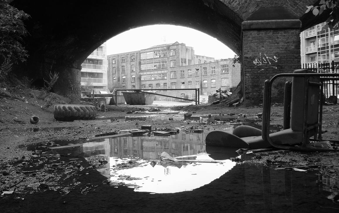
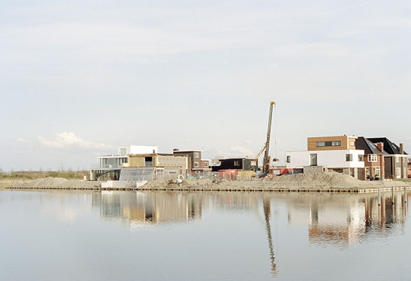
One of many pauses – Two Tree Island (2016), photograph by Rebecca Robinson
What begins as undifferentiated space becomes place as we get to know it better and endow it with value… The ideas “space” and “place” require each other for definition. From the security and stableness of places we are aware of the openness, freedom and threat of space, and vice versa. Furthermore, if we think of space as that which allows movement, then place is pause; each pause in movement makes it possible for location to be transformed into place (Tuan, 1977: 6).
By turning my lens on the Thames Gateway and presenting my findings to an audience, I am not only transforming what would be an abstract space to many, into a knowable place, but I am also imparting my unique sense of place. Not only this, but Paglen following Lefebrve suggests that if production is a fundamentally spatial practice, then cultural production is also a spatial practice. Speaking about geography, he states ‘when I study geography, write about geography, teach geography, go to geography conferences…I’m helping to produce a space called “geography”’ (Paglen, 2009). Therefore, the same rings true of my practice within the Gateway region, I am helping to produce a space called the Thames Gateway that I then further refine into place. Paglen refers to this practice as experimental geography, and states that we can’t only see the production of space as an ontological condition, but that active experimentation with the production of space should be seen as an integral part of one’s own practice, and that this experimentation should be seen as production without guarantees. Space should not be seen as deterministic, and that the production of new spaces isn’t easy (Paglen, 2009). Cresswell sums up the space, place connection as the idea that space must be seen as a realm without meaning. When human beings invest meaning in a portion of space and then become attached to it in some way such as naming it, it becomes place (Cresswell, 2015: 16).
As a photographer and filmmaker, I am interested in the relationship between place and landscape. Cosgrove (1984) and Jackson (1997) define landscape as a portion of the earth’s surface that can be viewed from one spot. While in one way this may be an accurate definition, from a cultural perspective it is limited. This simplistic viewpoint combines what can be seen, with the way it is seen. Taking it from this viewpoint, landscape is an intensely visual concept, and, for many, a reading that is deeply entrenched with landscape art. Cresswell suggests that most definitions of landscape place the viewer outside of it, which he suggest is the main difference to place, which is intrinsically something that we see ourselves inside of, habiting.
Cresswell chooses to use Raymond Williams’ novel Border Country (1960) to illustrate this point. The novel’s protagonist returns to his childhood home in the Welsh borders after years away at university. When he returns he is surprised that he has forgotten the quality of life that helped define it as a ‘place’, instead his mind has now been replaced it as a ‘landscape’. Over the course of the novel it shifts back towards a place as he becomes reacclimatised with village life. Cresswell ends the section by stating ‘we do not live in a landscape – we look at them.’ (Cresswell, 2015: 18). Williams stated that ‘the very idea of landscape implies separation and observation’ (1985: 126), placing landscape as a ‘pre-given external reality which a detached subject observes and represents’ (Wylie, 2007: 3).
Casey explores the connection between place and landscape from the position of exploring landscape art, but in particular painting. His view is that place is something experienced by the body. The ‘spirit of a place’ is captured through the ‘essence of a scene’. If we merely ‘capture scenery’, it results in a degradation of that place. In order for the artist to ‘capture that essence’, they must penetrate into the depths of the place, and must identify with the landscape (Casey, 2002: 99). He further suggests that ‘place is what is primarily transmitted in landscape painting’ (ibid: 114). John Wylie builds on Casey’s position on landscape by suggesting that ‘Landscape is tension’ (Wylie, 2007: 1). He further elaborates that the ‘tension exists between proximity and distance, body and mind, sensuous immersion and detached observation’ (ibid:1). Casey suggests this tension exists in the horizontal-vertical schema that was developed by Claude Lorrain within landscape painting and would permeate ideas of the picturesque[1] that existed within the landscape tradition during and after the eighteenth century. Casey suggests that the positioning of the lived body of the work’s author presents verticality and nearness, while the horizon serves distance and farness.
Wylie asks whether the word landscape describes a mutual embeddedness and interconnectivity of self, body, knowledge and land, just as the painter Cezanne wrote that ‘the landscape thinks itself in me… and I am its consciousness’. Wylie questions whether this is artistic egoism and hyperbole, the artist claiming ownership of a landscape through his depiction and view of it. However, once again, it is a view of landscape that fits within Williams’ viewpoint that landscape is something we look at from afar, until we experience it, and then it manifests itself as place. Wylie further suggests that Cezanne’s painting was produced through the artist ‘plunging his whole body and spirit into the landscape, creating a originary and inescapable involvement with it, that results in a folding and fusing of landscape and self’ (Ponty, cited in, Wylie, 2007: 2-3).
Further expanding on Wylie’s view, at this point landscape becomes a phenomenological experience, the relationship between observer and observed, the self and the landscape become intertwined. If we consider the original view that landscape is the measure of space that we can witness from a single point, then clearly landscape is an exercise in embodied reading of space. The difference between the observed and the observer becomes compressed; the horizontal and vertical schema is rendered two dimensionally, just as it is in painting and lens-based representations. At this moment, surely the real fusing is between landscape and place. The landscape viewpoint is unique to the observer and observer alone, whether it is the original or an artistic representation. Everyone’s perspective, physically, emotionally, intellectually and culturally will differ. At this point the representation can be said to become place in its own right, while at the same time, as Paglen stated, becoming a new space. The space of the artwork, within which each participant will create their own node. Cezanne is not the detached spectator that fits within Williams’ views, his gaze enters the landscape, probing, forming judgements, transforming its state, while at the same time the landscape enters him and allows this to happen, a symbiotic relationship. Williams would have us believe that we are detached viewers, Cezanne showed us that far from it, landscape is a live and embodied experience, and when we turn our eyes upon the painting we are able to see both, the painter’s vision and the landscape that has informed it. Landscape becomes ‘practiced’ through place-making activities, which include but are not limited to ‘looking’.
Since the 1970s, human geography and linked disciplines have moved away from the ‘field science’ model of landscape, and have looked to emphasise the ‘qualities’ of landscape. The idea being that landscape is a territory of cultural practices and values, as opposed to simply a series of observable material cultural facts (Wylie, 2007: 5). Increasingly, UK based cultural geography has sought to position landscape’s cultural practices as very much sitting within the notions of inhabitation, embodiment, and dwelling. Tilley (2004) suggests that the researcher must now not only theorise landscape through corporeal dwelling, but also must come to know it through participating in it with their whole body.
We can argue that both the Gateway region and the concept of edgelands exist within what Doreen Massey described as a ‘global sense of place’ (1991). The view of many observers was that globalisation was eroding places, reducing once distinctive places to uniform suburbs and ‘clone towns’ dominated by chain stores (Cresswell, 2008). This is an image that is certainly recognisable within the Gateway region. Massey even comments on the conflict within the development of London Docklands at the time. Docklands is place she described as being clearly defined by a conflict over its past and the idea of heritage, conflict over its present (1991) development and conflict over its future (Massey, 1991: 6). Massey however argues that far from eroding place, globalisation forces place to be constantly remade. The global connections can lead to endless series of specificities that contribute to the accumulated history of a place. Massey suggests that from this perspective place is being reshaped by both local and distant connections, leading her to call for progressive notion of place to be developed. The first and most important idea to her was the notion that place should not be seen as static. As place is formed though social interaction, then we should consider these interactions to not be motionless things frozen in time, both place and our interactions with it should be seen as processes (ibid).
Massey is most keen to point out that a global sense of place does not erode or deny place and certainly doesn’t erode the ‘importance of the uniqueness of place’ (ibid), and suggests that global flows actually give places a greater number of social relations from which to form the unique character of a given place. This distinct mixture of relationships combines local and wider factors, and leads to an accumulated history, with that history being comprised, as it always has been, with layers of linkages that connect to both the local and the wider world. Indeed, if we consider Queen Elizabeth I’s speech at Tilbury in 1588 to troops preparing to repel the Spanish Armada, as a single point in global space, it connects to multiple other points, which in turn opens the place to a series of global connections and places. This sense of the global and local combining means that the landscape becomes an even greater assemblage that comprises actors and agency on a global scale.
Queen Elizabeth I at Tilbury. St Faith’s Church, Gaywood.
Finally Massey suggests that places do not have boundaries, in the sense of divisions, that frame simple enclosures. While she isn’t removing the notion of inside and outside, she is instead stating that place is informed by the notion of what’s outside, which then becomes part of the place that it originally sat outside of. This helps to get away from the idea of penetrability and vulnerability, an association that traditionally made the notion of invasion by newcomers threatening (ibid).
Cresswell suggests that on smaller scales we are often hard pressed to think of the idea of where a place begins and ends (Cresswell, 2015: 104). However, the Thames Gateway master plan, including the idea of local economic zones, does exactly that and places need boundaries on to pre-existing ideas of place, whether on the regional scale, such as the creation of Ebbsfleet Garden City (Ebbsfleet Development Corporation, 2016), or through changes to the area on a local scale such as the development of St Mary’s Island or Chatham Waters for which the developers The Peel Group, have created a ‘new brand identity’ (About the site, website, 2017), for a pre existing place. To Cresswell, this negates the multitude of flows that cross these boundaries constantly (Cresswell, 2015: 105). I therefore find it easier to consider the whole region to be fluid, a constant shifting mass of place and places that will look different to the observer based on the perspective viewpoint they choose, but one that operates on a local, region, national, and global scale, simultaneously and has cause and effect that flows in both directions. This concept is reflected in my idea that the Gateway’s landscape is formed from small, island-like edgeland sites, that form an archipelago of interstitial land. When writing about the place where she resided, Kilburn, Massey describes it as a ‘meeting place’ where a ‘constellation of social relations’ come together to form place. While reflecting on Massey’s work, Cresswell describes it as a place she has great affection for, but this affection is based on the fluidity and diversity, instead of a sense of unitary identity (Cresswell, 2015: 106).
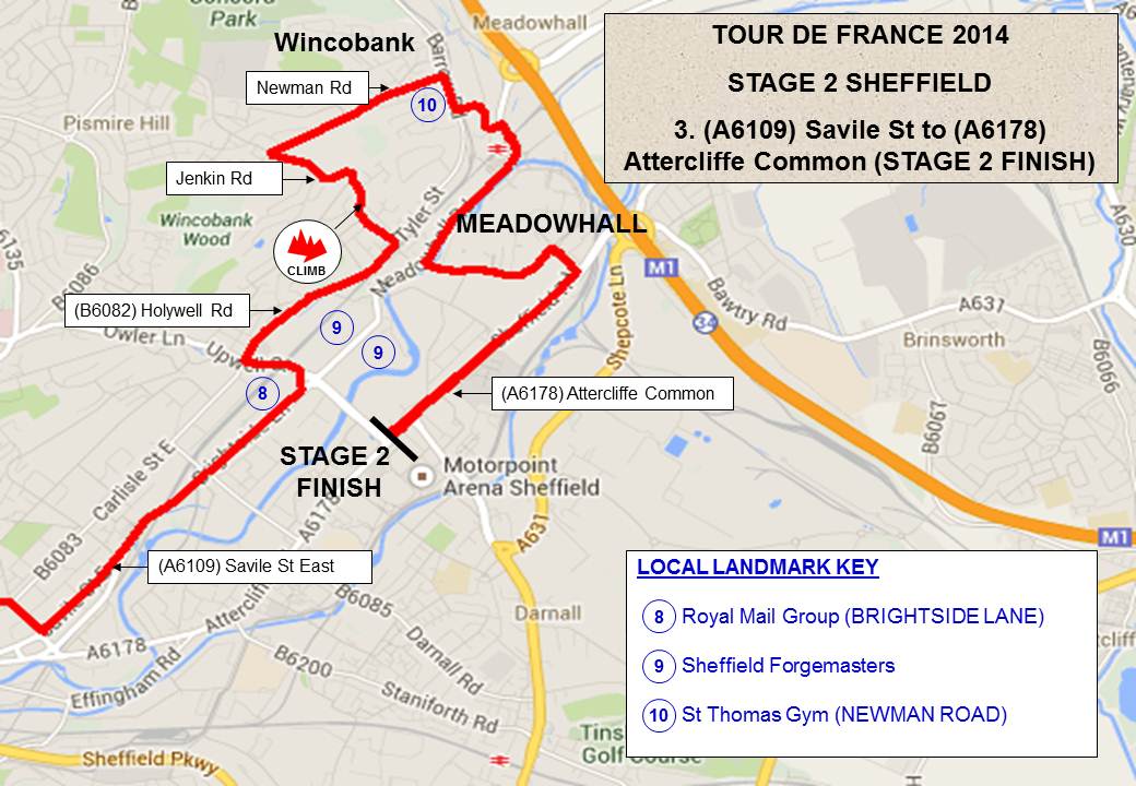
14 Zones of Change within the Thames Gateway, as identified by the 2003 Sustainable Communities Plan, adapted from GLA (2004)
Again, because place is formed through perspective and the personal, it cannot have a unitary identity. The Thames Gateway is a collision of factors at any given moment. However, Massey still suggests it is acceptable to seek identity in place, because the identity is never fixed and bounded (Cresswell, 2015: 109). In spending 12 years looking for the identity of the Thames Gateway I have always failed because of this point, instead I can only produce an autobiogeography that is about my search and my relationship with place. In doing so, ultimately, I am producing a place and a landscape that someone else can connect to and build upon. This is also the reason that the Thames Gateway failed to take hold of people’s imaginations as a new place; it is too large and made up of too many individual ideas of place on multiple scales. It is also the reason that the idea of edgelands ceases to exist when explored from the ground.
Shoard’s model requires the idea of a border space between urban and rural, in reality this border is an imaginary divide, it shifts and flows in the same way as the Thames Gateway. To Massey, all place, whether it is a social/human landscape such as a city space, or the physical/natural landscape of somewhere like the Lake District (Massey, 1991, Cresswell, 2015) is an event, where things are ‘thrown together’, and this requires a different idea from the one that views places are separate and particular.
The development of Leamouth photographed from the Emirates Air Line
The notion of place has been explored in relation to the metaphor of weaving, this describes the gathering qualities of place, with a unique texture formed through the way differing threads are combined. Adams, Hoelscher, and Till, calls us to think about the ‘texture’ of place, suggesting that while ‘we might think of texture as a superficial layer, only “skin deep”, its distinctive qualities may be profound’. (Adams et al, 2001: xiii). Robert Sack suggests a ‘weaving’ together of different realms of warp and weft, realms comprising society (and the moral), nature (and the empirical), and culture (and the aesthetic), that are gathered and ‘woven’ (fixed) into place (Sack, 2003: 41). The analogy of weaving and textile is a useful one especially within the context of the Thames Gateway as, while these realms exist within all place, they can be woven into any unique garment imaginable. On top of this the fabric produced is able to breathe and move under the influence of external factors, and finally that fabric can be continually recombined and refreshed. This idea of place as weave, joins Casey’s idea of a ‘gathering’ (1996: 19) and DeLanda’s notion of place as ‘assemblage’ (2016). Finally Cresswell (2004) draws these ideas together after Massey to define:
Place as process
Place as defined by the outside
Place as site of multiple identities and histories
A uniqueness of place defined by its interactions.
Conclusion
This chapter has explored ideas surrounding space, place, and landscape. By presenting both a theoretical starting point for these three terms, and exploring how, at first, they appear as similar concept, they can be considered as evolution phases of knowing a site. I have shown that while space is a concept largely devoid of a fixed location, both place and landscape are formed through ever deepening bodily interaction and knowledge. Because of this there is a movement from outside to inside place that transforms it into landscape, this is further defined through the movement from global to local, and the drive to connect the landscape to this wide framework of nodes, that can both be collapsed to connect the global to the local, or expanded to make the local, global. This idea is at the heart of my proposed landscape ethnography, and demonstrates the importance of forming a ‘deep’ experiential reading.
Within the next chapter I will further explore the ideas of the interstitial landscape, and propose methods for accessing this landscape.
[1] The Picturesque is explored in detail in Chapter Four.
How Can a Multimodal (Auto)ethnographic Methodology Be Deployed to Shape Geographic Imaginations of The Thames Gateway?
No plot so narrow, be but Nature there,
No waste so vacant, but may well employ
Each faculty of sense, and keep the heart.
Samuel Taylor Coleridge (1797)
It’s been a long time since I sat down to write something for this blog, or in fact write anything. I have become the thing that I would grow to despise during my PhD, an absentee blogger. Just when the content starts to get interesting and you feel a growing rapport with the site, it ceases and fades away into silence.
This blog started almost at the beginning of my PhD research and documented roughly the first year of my work. During that time I was lucky to have the time, space, and support to find my voice and discover what was important to me and why the edgeland landscape spoke to me and offered comfort and escape . At the time I started my daughter was one, she is now eight. During the first year I used this site as a digital sketchbook and space to muse over ideas in public and it led to many interesting conversations with a wider community. As the year progressed and I started to find the direction that my work would pursue for the next three years, I had less time to sit and write in the way that I had been. PhD research is brilliant (mostly) at focusing your reading and exposes you to lots of work that I wouldn’t have found otherwise. However it also robs you of the space to explore the wider aspects of your work. At least this was my experience of the process. My time was now taken up with reading and trying to craft a major body of written and practical work. Due to the nature of my work, much of my time was taken up with field work visits to photograph and film a rapidly disappearing and shifting landscape. Taking time to look back at my initial research proposal I can see the bare bones of my research, but it would shift more than I could ever come to expect when I wrote those initial posts.
The last post I wrote was during a week long research school at Manchester Metropolitan University into Place Writing. It was an opportunity for me to expand my practice and was entirely as a response to the work I was doing on this blog. Until that point I had never considered my work to be in the tradition of nature writing, new or otherwise. The experience of being critiqued on my writing on a daily basis, with short turn arounds and nowhere to hide was both terrifying and liberating. Combined with the excellent Goldsmiths International Urban Photography Summer School (iUPSS) it would force me to open up and reconsider what I was doing with my work. Face frustrations with my practice head on and ultimately change the nature of what I was doing and how I was doing it. The resulting thesis documents this process and the change within my work. No longer did I consider myself to be a photographer (this is in a constant state of flux), but instead I found that I was a cultural geographer whose work embraced still and moving image. So much of my research and experience would be formed by my time in the Thames Gateway, walking, writing.
I don’t want this to be a rumination on the state of the world at the start of 2021, but like so many it has forced me to look at aspects of my life and my work has been a major stumbling block since I graduated in 2017. For a long time I was too tired and burnt out to even go near my research and work. Combined with PhD frustrations and guilt it would stop me being able to reflect on any of the work I had produced since 2013. The last year has seen me return to the Thames Gateway and my wider practice as both a writer, film maker, and photographer. It is time that I started sharing the archive that I have amassed over the years and the work that I have produced. This blog will shift into something different, something that it started to be during those first posts. A place to share work and muse about the landscape. A test bed for work and writing, a place to share the landscapes that I am still drawn to. It will still be under the title of Driving Thru Wasteland, as the reasons for selecting that name in the first place still ring true. It is still an act of escape and pilgramage. Sites and locations that I still need to explore.
Other the next however many posts I will be sharing my PhD thesis. After that point I don’t yet know my direction, but hope that people will still be interested in landscape ethnography, edgelands, and the Thames Gateway, before moving onto new bodies of work that will still continue to explore place, regeneration, and memory.
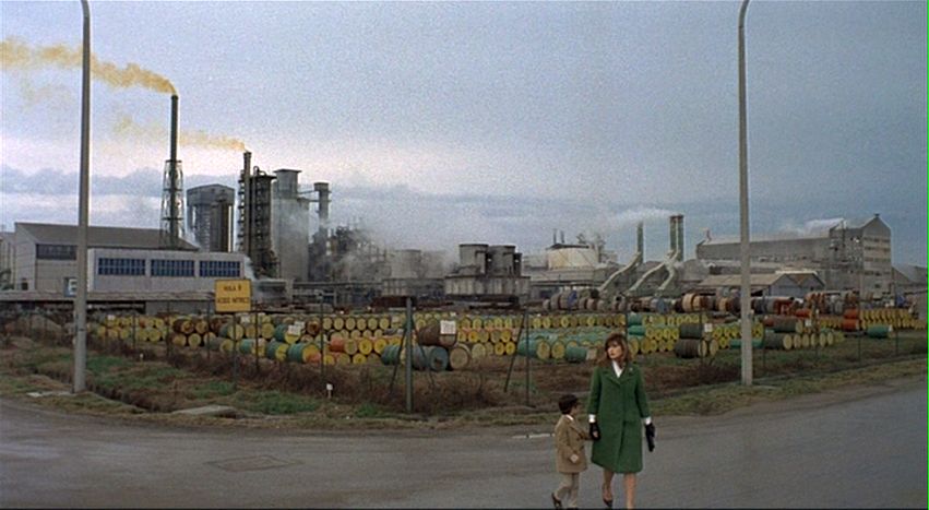
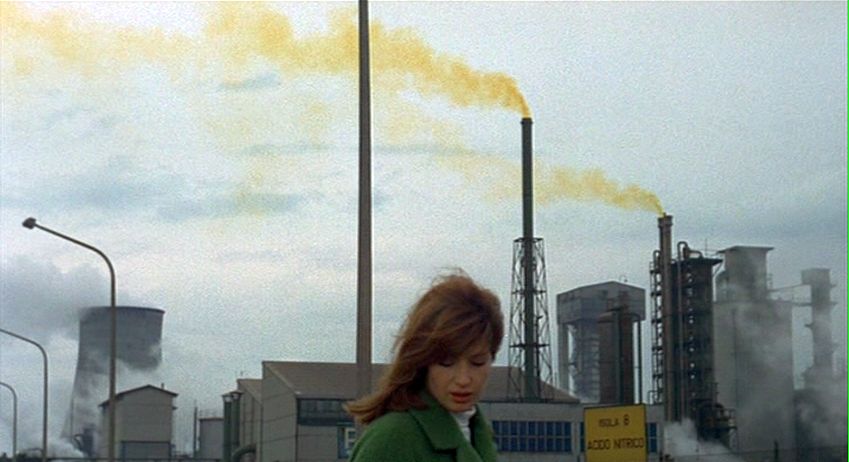
Filming Estuary England (2013), photograph by Rebecca Robinson
Introduction
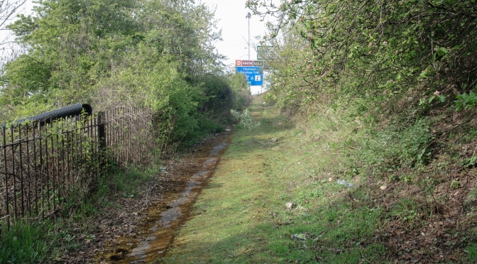
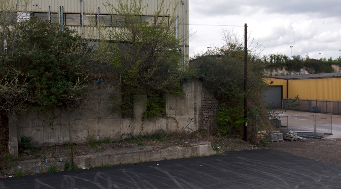
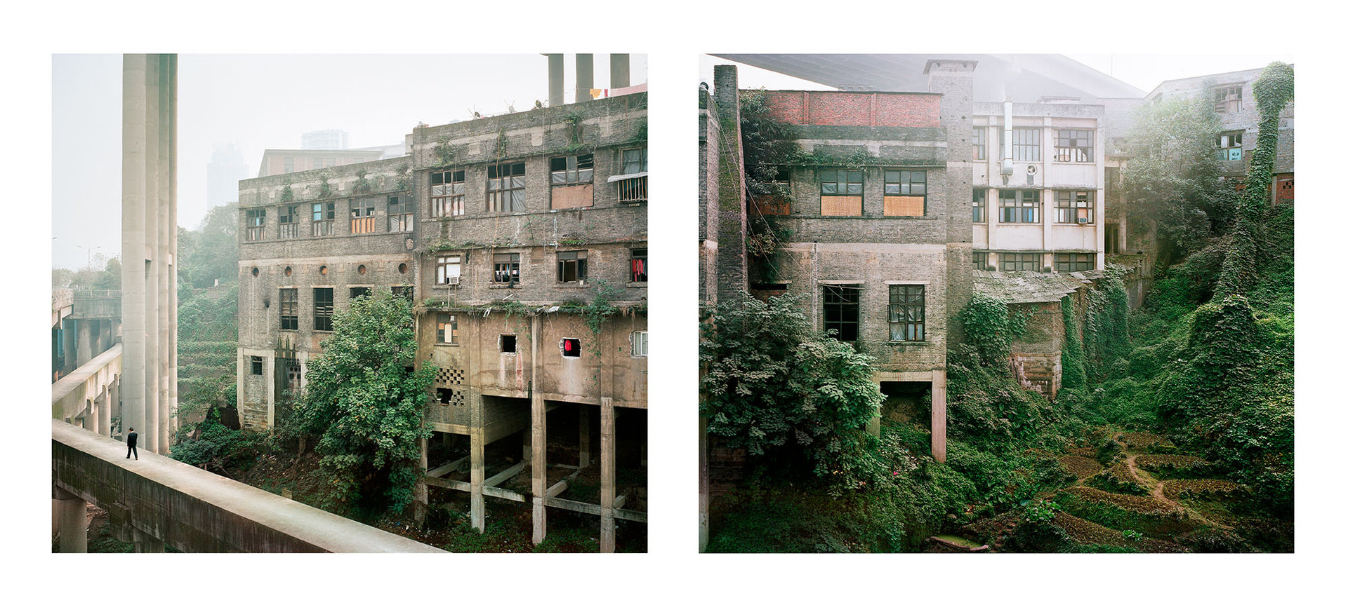
The A289 shoots out of the Medway tunnel, on either side of the busy dual carriageway are the remnants of the area’s previous life, the site is caught in a state of flux between its old and new life. A heavyset, tall red brick wall sits obscured by the new archways of the brick walkway that gently step up the slight incline, carrying walkers to the new bridge that flows over the road. Cars rush past former drill halls, now bearing the logo of the University of Greenwich. Like so much of the Thames Gateway’s industrial heritage it has now been superseded by new forms of business, mirroring the country’s shift to an economy based on the burgeoning service industry.Just past the bridge, two metal clad sheds mimic one another’s architecture, one a part of the university’s campus expansion, the other a fleeting reminder of the area’s dock heritage. Not the historic ship works that sit slightly further round the river’s bend, but instead the remnants of a more recent working dock that is now steadily being replaced with new development, ‘as cities start to fall back in love with their once neglected riversides’ (Grindrod, 2014: 424).The road widens as it approaches a new intersection in front of the new regional police centre that replaced the previous smaller stations within the town centres that make up the conglomeration of locations that form the unofficial ‘City of Medway’. Many years previously, my wife had photographed the boarded-up remains of Rochester’s police station, which by this point had become somewhere for the town’s homeless community to reside, making use of the building’s modernist nooks and crannies to make their beds, rubbish piles and toilets. Allowing the large format camera’s lens to render the misery of people’s difficulties in painful detail left us feeling ‘disgusted and guilty’ (Galer, 2008: 98). The camera’s limitations to record the multi-sensory reality of people’s lives, would eventually involve a shift from the topographic mode of photography to a ‘more than visual’ (Jacobs, 2013: 714) methodology.The road separates, peeling off to the newly christened Chatham Waters development, a mixture of high rise flats – wrapped in scaffold and mesh – and new retail opportunities mingling on the site of the former MOD base. The mesh cocooning the building work dances and shimmers in the wind. Hoardings surround a newly cleared section of site, waiting for groundworks to commence. The hoardings have replaced the blue palisade fence that used to surround the site, however they still bear the Peel logo, indicating the company responsible for the redevelopment of so many of the UK’s long dormant dock sites, such as the world heritage site in Liverpool. Alongside the logo sits the words Chatham Docks, however the context has clearly changed. The main attention of the new area is a large new Asda store; the car park sits hemmed in by the confines of the old MOD wall. Tucked next to the Asda petrol station forecourt is a tall green wire mesh fence, surrounding a series of deep ponds, obscured from prying eyes by a thick blanket of overgrown trees and vegetation. Large ‘Keep Out’ signs are bolted to the fence at ten metre intervals. As I peer through the undergrowth, it is possible to make out a scaffold structure that juts out, cantilevered over the dark water below. I have no idea what purpose this structure once served, but I am aware that the site was formerly a pond system for storing low-grade radioactive waste, from the next-door nuclear submarine refit base.A steep, newly-seeded green bank rises to an elevated berm next to the roadway. A light brown streak trickles down the bank, the early formation of a desire path, a visual clue to people’s need to explore the once off limits area. At the top of the bank a temporary security fence has been pushed over, behind it sits the rails to the train line that once served the docks, and would later be used to remove irradiated top soil from the man-made island that was formed by the digging of three large submarine basins, and would be regenerated into a new island community known as St Mary’s.The area is not far from where my wife used to work when we lived and studied in Medway, I once knew the area very well, but now it is increasingly unrecognisable. The speed of change has been drastic. The road acts as a separation between the old and new communities. Eight lanes of traffic form a divide between the established and the interloper. ‘These invisible walls infamously have been used to mark off the territories separating the rich from the poor, or race from race…in 20th Century planning motion has served as the instrument for making boundaries rather than borders’ (Sennett, website, 2008,).It is shocking to me to see the once busy train line that was a vital piece of arterial infrastructure, brutally severed. It no longer comes to any kind of civilised halt, instead the track just ceases. The sleepers carry on for several metres, but then everything simply tumbles down the embankment. Climbing over the prostrate fence I cautiously proceed up the disused tracks. Foliage is sprouting between the sleepers, pushing aside the granite ballast. The tracks themselves are tarnished and rusty, trains no longer polish the top of the rails. People have told me this is the simplest way of gauging a line’s use. A short way up the tracks is a bridge that crosses the busy road below. Police cars come and go from the neighbouring regional Police centre; I become slightly nervous trespassing this close to it. However, the bridge affords excellent views of the changing area, I am able to see over the hoardings into the waste ground beyond. The demolition of a pub has left a large vacant lot, no doubt waiting for developers to move in and transform it, to something more in keeping with the area’s new gentrification.As I proceed up the line towards the point that it once joined the mainline, I pass a community centre, and the local mosque. Holes sporadically appear in the fence, and small patches of fly tipping litter the embankments, general household rubbish, clothes, DIY materials. At this point I am still in view of the commuters coming back from Gillingham train station; every now and again, one of them catches my eye and looks on in slight confusion. Before long the track bends round to my left, and enters a steep-sided cutting, trees overhang the track and cut out the bright sunlight, a cold quiet stillness engulfs me. The distant sound of the busy road, and the general murmurings of life from the local houses fade to a still hush. Up ahead a tall brick railway bridge looms into my view, just before I reach it I notice a collection of women’s underwear discarded on the tracks. Two or three pairs of discarded thongs are spread over a small area, along with them I notice a series of discarded condoms chucked into the bushes. I am no longer shocked by what I come across in these areas, it is neither the first or last time that I would find evidence of sexual activity, just another example of the adventurous play (Edensor, 2005: 34) that I along with many others would come to recognise as one of the hallmarks for these interstitial folds (Deleuze, 1992: 267) in the urban fabric.The space around the base and underneath the railway bridge is covered in a thick layer of rubbish, black bin bags have been thrown off the bridge 10 meters above. Some have split open on impact, others lay piled in accidental sculptures. Many of them have become stuck behind the low-tiered fences that stop the bank from slipping. The stench is obscene; rotting food litters the ground, attacked by carrion and foxes. I gentle tiptoe my way through the filth, I notice packets of used medicines, addresses and names still on the prescription labels. Used hypodermics contain the thick sticky brown residue that I recognise as the visible sign of the region’s heroin problem. They are no different to the ones that the council had to collect from our back garden, thrown over the fence from the alleyway behind our rented accommodation.Alongside the daily ephemera and habits, there are piles of torn magazine pages, faded and with the muted colour pallete of another time. Staring back at me are images of women with big hair and unmanicured pubic regions. Some are simple soft-core ‘tits and teeth’ shots, while others contain the visceral depiction of penetration. A rough guess would suggest that the area contained something close to a hundred pieces of hastily torn imagery, ripped from its mother publication. This was clearly once someone’s illicit stash, collected from multiple magazines and kept, or passed on for several decades. In a few disturbing instances the images of genitals had been crudely torn from the image, however there was no sign of them in the litter. They had either been kept or discarded at an earlier date.Further up the line a tree has come down, blocking the rest of the track. The quiet atmosphere is broken by the sound of voices further up ahead. Three young teenage boys come down the side of the steep cutting, aided by a rope strung from the top of the bank. I watch for a short while as they play on the tracks, pretending to shoot each other. As I start to leave, they notice me and hurry to catch up. They make contact half way back to Asda, asking whether I have permission to be there and what I’m doing. I briefly explain about my research and film. I then ask them what they are doing; the response I get is not unexpected.
‘You know, stuff’
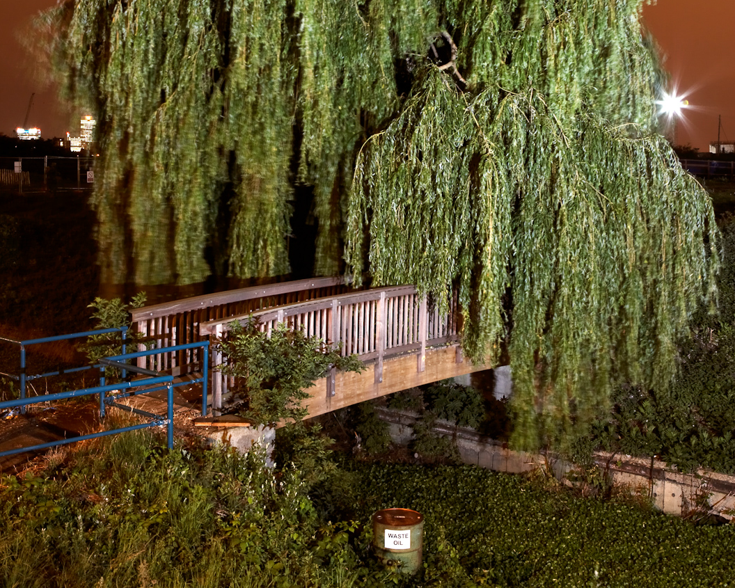
Under the bridge (2015), photograph by Rebecca Robinson
This experience mirrored multiple explorations into the landscape that surrounded my former home in Chatham, part of the Medway towns and the wider Thames Gateway region. These explorations were undertaken over the course of eight years of informal visits, followed by four years of intense embodied scrutiny. During this time the landscape would become the driving force in this PhD body of practice and research. It would change and alter my artistic practice as I attempted to understand and capture the nature of the place.
This practice led PhD looks to question how forms of multimodal (auto)ethnographic research can be adapted to investigate landscape and place, and how it can be deployed to shape geographic imaginings of that area. It does so by using a case study of a geographic region to explore a form of landscape that has become prevalent in the peripheries of our urban conurbations. It goes by a range of names and is almost certainly a landscape that is familiar to the general public, if even on a fleeting level. While they may be unable to name it, they are certainly aware of aspects of its character, whether from first hand experience or simply through the absorption of its image in the media[1].
In recent years, these areas have become known as edgelands (Shoard, 2003) and I, along with a range of artists and scholars, propose that they have an important, yet oft-overlooked, role which they play in our daily lives. Kenny Cupers describes them as ‘breathing spaces’ (Cupers, 2005: 3), calling them out as vital spaces of respite in our busy urban and suburban landscape.
Though often derided within the press, the region, situated on the eastern edge of Greater London, has been richly documented by a range of artists, academics, writers, and pyschogeographers, due to its rich post-industrial heritage. With that in mind, what I seek to construct here is a landscape ethnography (Ogden, 2011) [2] of the Thames Gateway region, once the largest regeneration area in the UK, and now the site of multiple interstitial areas stitched together largely though informal practices and engagements.
Throughout all of my photographic work there has been a strong autobiographical strand that connected myself to my subject matter and each of these subjects to each other. An illustration of this would be my navigating the series of disused asylums that ring the M25 and play a difficult part in my family history, with my grandmother being held in one for a period of time (The Darkness on the Edge of Town, Robinson, 2005). Or exploring the post-industrial landscape that I had encountered as a young boy and remember in an almost dream like state of fugue (The Smell of Bitumen, Robinson, 2007); or, with my wife, attempting to make sense of the landscape that surrounded us while we lived in Medway (18 Rochester Street, Galer and Robinson,2008). These experiences would form my earliest research into landscape, place, and psychogeography and would come to form the foundations of this thesis.
During the course of this research I became aware of the term autobiogeography (Gregory-Guider, 2005), from an essay about Iain Sinclair, and Rachel Lichtenstein’s book Rodinsky’s Room (2000). Gregory-Guider described autobiogeographical as a ‘dynamic interpolation and interbraiding of person and place, alternatingly framing the former from the vantage point of the latter, and vice versa’ (ibid., website, 2005). This statement sums up my experience of undertaking this research and the need to design a methodology that allowed me to frame the landscape and my own experiential reading of it in a curated manner.
This research has developed from spending prolonged periods of time in the landscape, as well as a previous personal history with the area. These periods of time took the form of a ‘deep hanging out’ (Geertz, 1998) with the landscape, and was the starting point for an adapted (auto)ethnographic methodology, and the development of a landscape ethnography, which looks to blend and formalize elements of Chicago School ethnography, with elements of Sarah Pink’s writings on creative and sensory ethnography, as well as psychogeography and creative non-fiction in the form of new nature writing. The development and adoption of the auto-ethnographic voice has come from allowing the landscape to inform the shape of the practice, and allows me to act as a narrative conduit to unpick the pyschogeographic elements that mirror Doreen Massey’s writings on place, history and story. This adapted (auto)ethnographic methodology works through written narration, and aurally through the resulting film work’s soundtrack, comprised of multiple field recordings.
During the course of this research my practice has shifted from still to moving image. This is a reaction to frustrations with limitations within the still medium to capture the multiple sensory nuances that form the landscape. By shifting to moving image I am looking to embrace a ‘more-than-visual’ (Jacobs, 2013: 714) approach to my practice; film allows us to ‘listen with our eyes’ and ‘listen to our eyes’ (Jacobs, 2013: 715). This shift has also been within the visual framing of my images, moving from a topographic viewpoint to an embodied lens that acts as an extension of my bodily inhabitation of the landscape, grounded through the tripod to the soil.
The italicised passage that opens this introduction is taken from a series of (auto)ethnographic notes that I would make to support my walks within the Gateway region. They will be present in this format throughout the thesis and are designed to act as a lens through which the reader can experience the landscape, but also to add my voice to the moving image work, tapping into both new nature writing (Cowley, 2008) and (post)Sinclairian psychogeography[3] (Cross, online article, 2004, Richardson, website, 2014). While these (auto)ethnographic writings started as merely a note-making method, they developed, through my accompanying blog Driving Thru Wasteland (Robinson, 2013-15), into a vital part of my methodology. Combined with these (auto)ethnographic passages, the thesis switches registers, depending on the subject being discussed. These registers explore the personal ethnographic connection to place, a close critical reading of photographs, films and text, which in turn forms a reflexive strand that connects back to the development of my practice and a scholarly development of theoretical themes. These shifts in register echo the ideas that will define landscape ethnography, balancing a quasi-scientific distanced observer in my early photographic field trips, (especially in the work inspired by the new topographics, and explored in Chapter Three), and an immersed ethnographic approach that was adopted in my film works. This shift in register and practice is also greatly informed by the ideas and methods of new nature writing.
Chapter One explores ideas surrounding space, place, and landscape, and how these states are framed and formed. This acts as a theoretical framework to explore, in later chapters, the specifics of place within the Thames Gateway, and how the interstitial landscape is positioned within the wider debate surrounding place. The chapter includes ideas that are fundamental to the formation of a landscape ethnography methodology. It explores notion of place as put forward by Tim Cresswell and the shift or return to the idea of landscape within geography as explored by John Wylie. Both of these embodied readings of place and landscape will counter Marc Augé’s notion of Non Place.
Chapter Two looks to outline the spatial characteristics that are found in our interstitial landscapes. By asking the question, ‘what are edgelands?’ I will outline the formation of the term and its relationship to earlier notions of the interstitial landscape, exploring how these differ from Shoard’s later term. It will build upon the work of other researchers who have explored this landscape, in particular the work of Farley & Symmons Roberts, who wrote the first exploration of the characteristics of edgelands and ultimately formed a typology of key defining factors. Further to this it looks at our relationship to these sites, as well as means of access and interaction. It explores both positive and negative associations with the term.
Chapter Three will explore ideas surrounding landscape representation in the work of artists, and this will take the form of an analytical overview of historic practices concerned with the depiction of ruins, linking to themes of the picturesque and sublime. It will look at the work of the New Topographic movement that came to define an idea of new landscape photography and a new wilderness. It will explore work that has allowed me to define a methodology that informed my visual understanding of edgeland spaces, and open up a visual chronology in advance of the term edgeland being coined.
Chapter Four will define landscape ethnography’s adapted ethnographic methodology. It will do this by forming connections to; psychogeographic practice, autobiogeography, and new nature writing as a literary framing of a given landscape. These practices will be contextualised in relation to non-representational theory. Finally, connections will be formed between all of these methodologies to the metaphorical idea of ‘deep’ exploration and production of the landscape. Sarah Pink defines ethnography as “an approach to experiencing, interpreting and representing culture” (Pink, 2007: 18). Therefore, by extension, a landscape ethnography is an approach to experiencing, interpreting and representing landscape.
Chapter Five will explore my connection to the Thames Gateway, setting out the notion of my autobiogeography, and ultimately develop the idea of why it was chosen as a region for my fieldwork. It lays out a history of both the region and individual locations I have been working on a macro/micro scale, and explores the politics, the changes, and the future for both individual sites and the wider Gateway region. It deals with elements of gentrification and the argument for preservation of the region.
Chapter Six further refines the research methodology by defining the framework upon which the fieldwork was undertaken and through which the practice developed and evolved. It explores ideas surrounding the use of walking as a means of research, linked to ideas of psychogeography defined in Chapter Four. This will be done by assimilating various ideas found within ethnographic study, including: Sarah Pink’s work on visual and sensory ethnography. It will further explore the connection between film, ethnography and geography as written about by Jessica Jacobs and multiple others. It also defines the shift in practice from a visual photographic model, to a polysensual moving image model. Further to this, it explores how my films link to a tradition of landscape films that preceded them, including the psychogeographic cinema (Scovell, 2016) work of Patrick Kieller, John Rogers, Andrew Kotting, Adam Scovell and Chris Petit, and their connection to psychogeography.
Chapter Seven and Eight will map the development of my practice from the first fieldwork trips which utilised the idea of ‘eye witness, ear witness, cartographer and interviewer’ (Hanley and Dargavel, conference paper, 2012:1) as a basic methodological framework which was ultimately adapted into a more appropriate (auto)ethnographic framework. It explores the development of my practice, laying out my finalised methodology and the process that the wider research has played in informing its creation. It reflects on the process of exploration and the formation of a series of film works. This chapter will account for the visual language and conventions used within my films, including notions of framing, sound and music through an exploration of my work and the work of other artists working within similar landscape orientated fields.
Within the Conclusion, I summarise how each chapter has contributed to my argument, allowing me to question how landscape ethnography can be utilised to create work that blends geography and art to form works that cannot be produced by traditional written publications and ethnographies. The Conclusion culminates by suggesting a direction landscape ethnography might take in the future, utilising emerging technologies to create more immersive ethnographic experiences.
[1] The edgeland and interstitial landscape is often used as locations for police procedural dramas, and British social realism film and television (see Edensor, 2005).
[2] While Gillian Ogden proposed landscape ethnography in her book Swamplife: People, Gators, and Mangroves Entangled in the Everglades (2011), I am looking to redefine it in relation to defining a sense of place through elements of (post) Sinclairian psychogeography and new nature writing to form immersive filmic geographies of the landscape.
[3] While ideas surrounding psychogeography play an important part in this research, there is not enough space to explore the wide history and development of the subject. For an extensive reader on psychogeography see Merlin Coverley (2010). While Coverley and others widely consider Iain Sinclair’s work to be vital in redefining psychogeography in the Post-Situationist era, Sinclair himself has called for ‘a young group of urban walkers to pick up the mantel of psychogeography and do something new with it’ (Sinclair quoted in Richardson, website, 2014). Richardson defines this idea as new or post-Sinclairian psychogeography.
Over the past three days I have been attending a short writing course at Manchester Metropolitan University on the subject of place writing. The course has been excellent and encouraged me to start writing again, as well as consolidated some ideas surrounding my practice.
The following piece was written as today’s short assignment and was complemented by a series of photos taken on my IPad to act as visual notes for the written piece.
Under the A57(M)
I unsurprisingly find myself under the expressway of the A57(M), the shortest section of motorway in the UK. Even in Manchester’s packed streets I am able to find respite from the busy world.
Tucked under the overhead road, the world around me melts away, the sound of the busy streets and cars becomes muffled, except for the noise of a game of football going on in one of the subterranean five a side pitches that have become a staple of our urban infrastructure.
All of the areas sunken walk ways and roundabouts remind me of Deleuze’s writing about islands, continental, born of erosion and dis-articulation. Urban archipelagos adrift in the shipping lanes of Manchester’s busy roads. The converging paths slip down the slope, ducking under the roundabout above, waiting to act as unofficial watercourses once the rain starts.
The asphalt paths remind me of the Croydon suburbs that my grandparents lived in. Strangely smooth and devoid of noticeable aggregates, and just like the tree lined suburban avenues, the trees planted at the top of the banks have forced up the cobbles up into undulating waves, the concrete curb stones hefted up by this shifting sea, only to later crash back down, breaking into jagged edges. Tucked underneath these stones is the usual collection of detritus, but a cleanly picked bone catches my eye, spotted and picked marked, the remnants of someone’s late night dirty chicken stop.
The cobbles have been oddly covered in a thick bitumen, like the waterproofing on that hull of a ship, I am at a loss for the reason why. For a second an absurd idea pops into my head, maybe it’s to stop them being nicked. My eye stops on a patch of missing cobbles further along the path, now a rock pool of moss and lose soil.
The stones directly under the overpass are stained in huge grey circles, one, two. Looking up I see the reason, stalactites hang from the underside of the concrete, slowly dripping onto the floor below, the limestone, leaching out of the damaged concrete.
This is an area I know from previous research, the site of the odd motorway exit to nowhere, built to a point and then stopped meters into the air. Like so much of our concrete cities, a reminder of a future, promised, that never came.
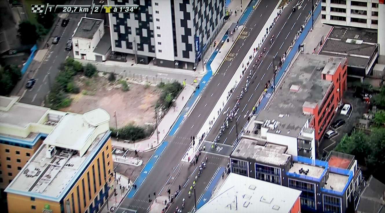
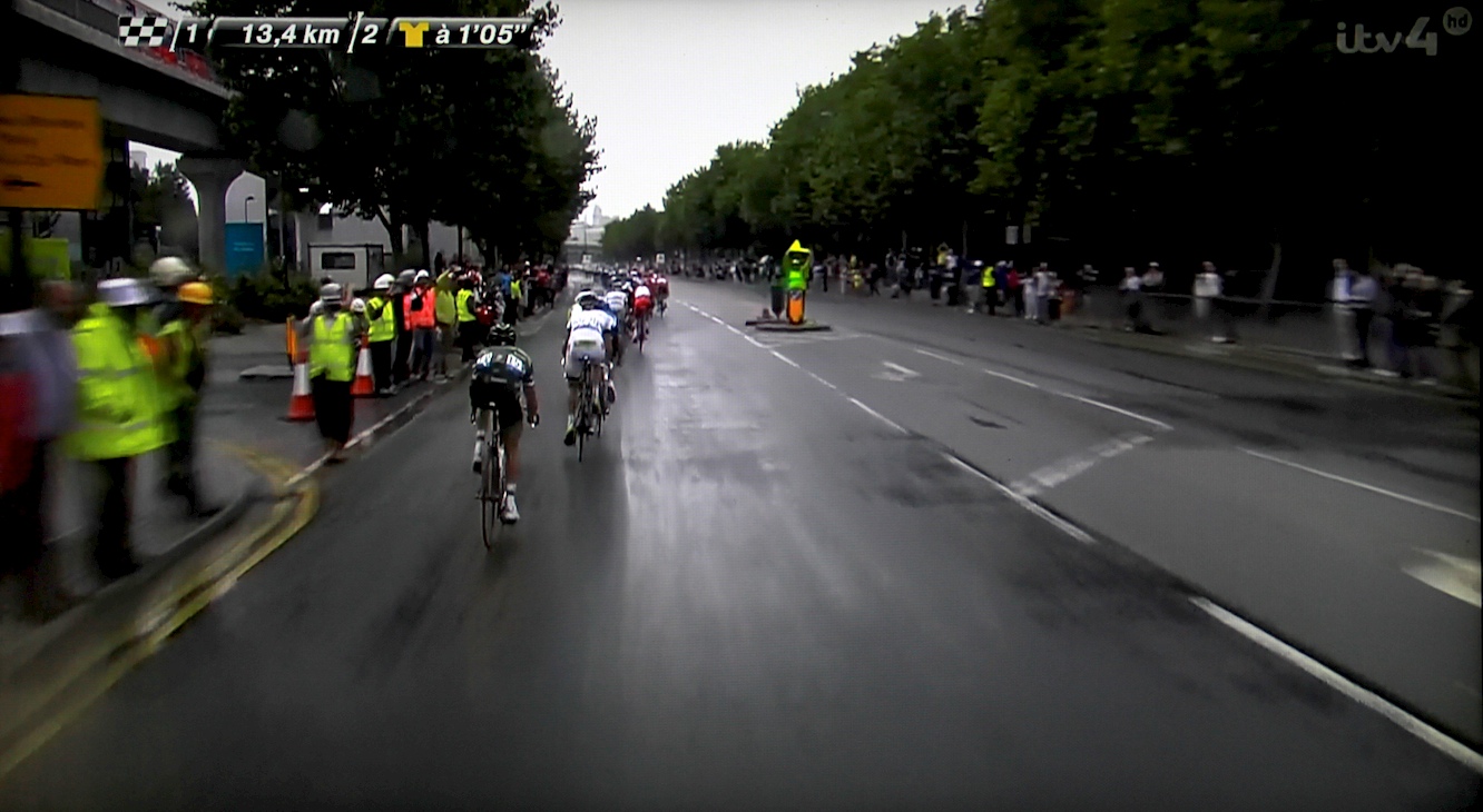
The last time the tour was on English soil was 2007 when it past through Chatham in the Thames Gateway for stage 1. At the time my future wife, studying for her MA, lived in a small Victorian terrace, near the station and close to the route. She was lucky enough to see it pass at the bottom of the hill below UCA Rochester (technically Chatham), her recollection of it is about 30 secs of bikes zooming past.
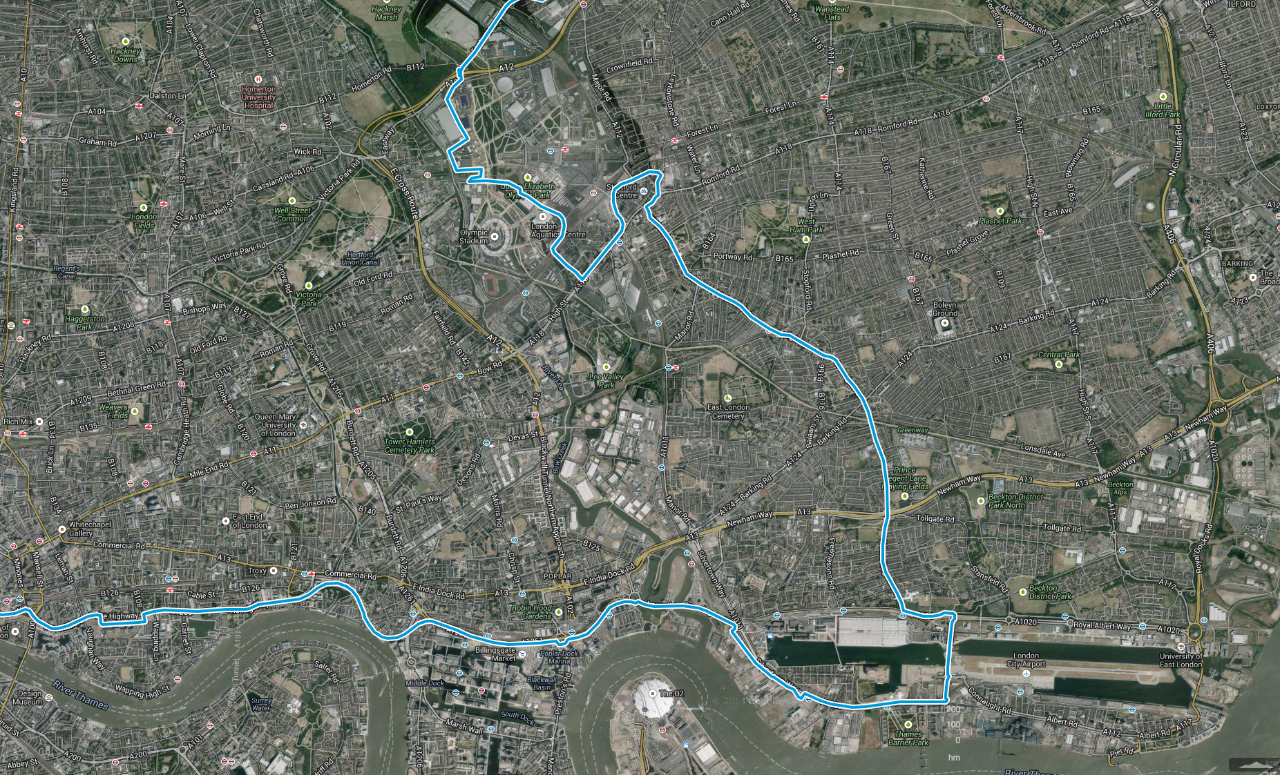
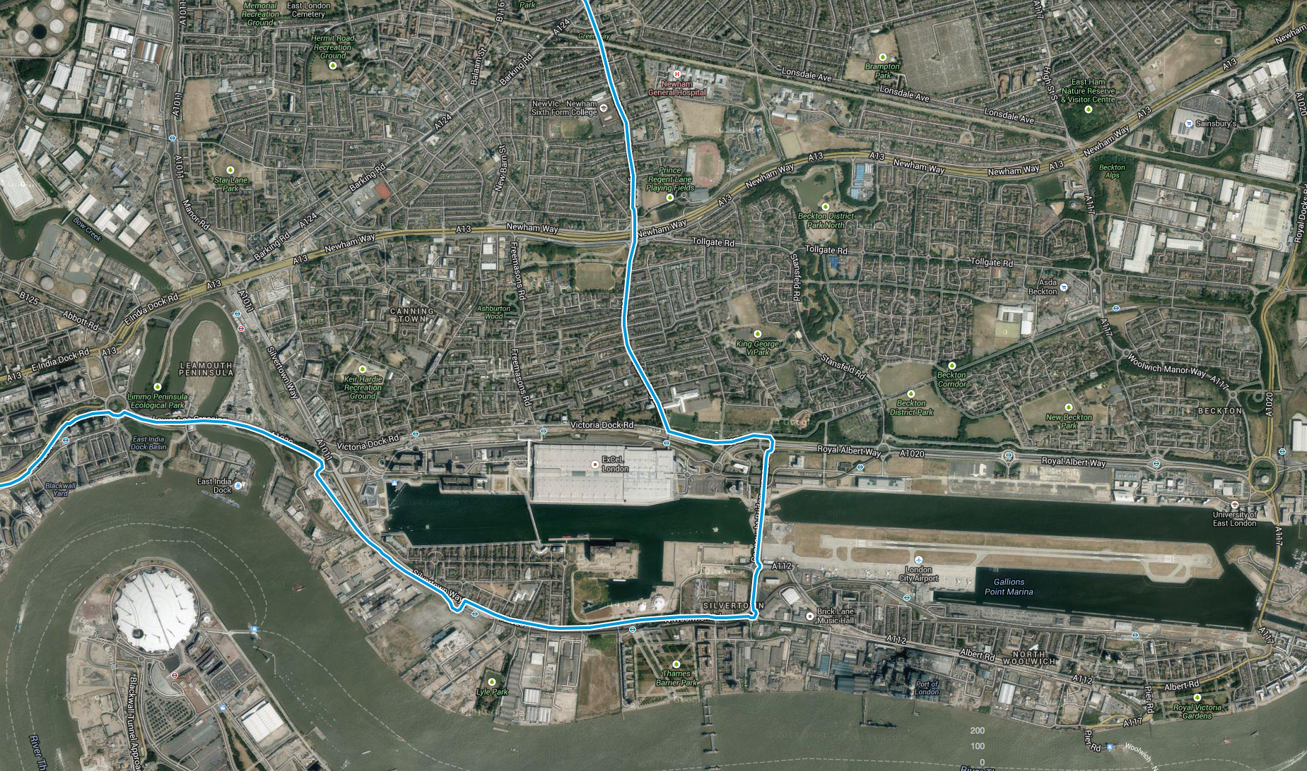
The route of Stage One of the Tour De France 2007 as it passed through Chatham
The stage took place on a Sunday, if it had been a weekday it would have interfered with her walk to work as, the route followed a similar route. It came under the river, through the Medway Tunnel, emerging close to Dickens World, the old Royal Docks and close to where she worked. At the time she worked for a sub prime credit company, in the collections department, and a large part of her job involved trying to arrange payments from people who really shouldn’t have been given a credit card, or pretended to have no idea how credit and interest worked in the first place ‘so what do you mean, I have to pay for what I bought, and stuff on top of that, THAT’S NOT FAIR’! In some instances the interest rate was as high as 69.9%, however she on the whole enjoyed the work, the company were good to her and it fitted around her time at uni.
The former home of one of the UK’s first and largest sub prime credit lenders
There offices overhung one of the huge submarine ponds that acted as a demarcation zone between the mainland and St Mary’s Island. It was Rebecca that first became interested in St Mary’s and persuaded me that we needed to take a walk around it. This is important to point out, as the last time I wrote about the area I suggested that I came across the location. Rebecca gets very annoyed about me claiming credit for things, I blame the passing of time, but reality is I do steal her ideas.
I revisited for the first time in a while, a few months ago, and the first time with a large format camera. The site hasn’t changed much over the years, mainly due to the economic downturn, they are still working on what was then phase 3, The Fishing Village, with the western edge of the island still an unkempt wasteground hidden behind large wooden hoardings. An exercise in screening the new community from the reality of a locale, a phenomenon that Amy Hanley and Rick Dargavel write about in their Edgelands paper
St George’s Island
Screening ‐ Visual concealment makes social context invisible. A typical example is St Georges Island, a luxury apartment development in the centre of Manchester.
St George’s Island
St George’s Island
It occupies a site between the Bridgewater canal, the Metro tramline and a disused viaduct.
St George’s Island
St George’s Island
St George’s Island
The developers used hoardings to visually and physically separate the arches below the viaducts that are used by the homeless as places to shelter, eat and sleep.
derelict brick railway arches, St George’s Island, Manchester,
The hoardings advertising mirrors the luxury lifestyle and aspirations projected by the developers and is blank towards the homeless spaces.
St George’s Island
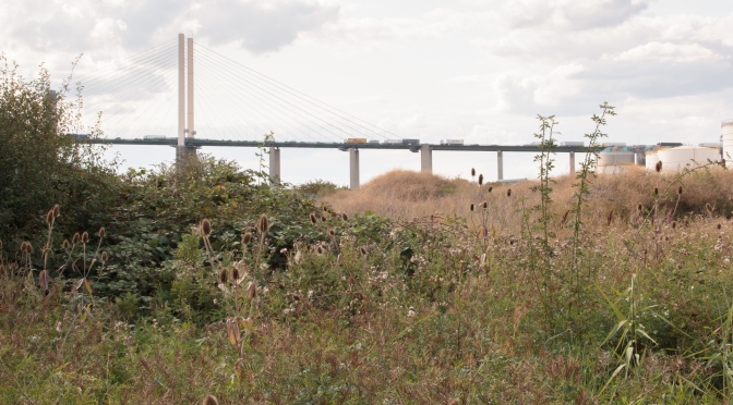
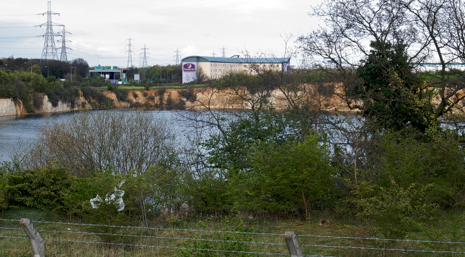
This visit to St Mary’s came at the end of a two-day period working on exploring the Thames Gateway and Identifying sites. As usual I choose to stay in an edgeland Premier Inn Hotel, this time on a roundabout in Purfleet, next to the M25 and Dartford Crossing. The hotel was stuck between water filled chalk pits and distribution centres, the most impressive of which was situated in an old pit and took up the entire space, with an access tunnel bored through the cliff.
To the south was the high-speed rail line, the only development of note during the original Thames Gateway scheme.
Estuary English- West Thurrock, Simon Robinson (2012)
I started by revisiting sites that I first came across in 2012 during my first recce visit. That time I stayed with my now pregnant wife in an Ibis where she purposely asked for a room overlooking the motorway and QE2 Crossing. It was the same hotel that Ian Sinclair visited while working on the film version of London Orbital by Chris Petitt.
I started at St Clement’s Church, and sits in the shadow of the Proctor & Gamble works, which belches out a constant vaguely unpleasant sweet smell.
St Clement’s Church & The Proctor and Gamble works
The church of St Clement is in St. Clement’s Road, south of Hedley Avenue. Until the earlier 20th century it stood alone in the Thames side marshes, but it is now surrounded and dwarfed by factories, warehouses, and a power station.
Estuary English- West Thurrock, Simon Robinson (2012)
The choice of such an isolated and inconvenient site has never been explained, and there was apparently no human habitation within 800 metres but the road to an ancient ferry passed close by and some believe it on the route of pilgrimage to Canterbury to visit the shrine of Thomas Becket. Pilgrims were said to either cross the Thames by boat, or at low tide it was then possible to walk across, using a ford which used to exist before the river was dredged in modern times to allow it to be used as a shipping canal.
The eponymous funeral from Four Weddings and a Funeral, Mike Newell (1994)
As usual I parked in the tiny laybay just before the main entrance. You walk down a sandy path in a tiny copse of trees between the plant and the site of the former West Thurrock power station.
Estuary English- West Thurrock, Simon Robinson (2012)
The coal-fired station closed in 1993 and was later demolished. The large bulk coal unloader still sits at the end of the Slipway on the Thames.
The coal unloader at West Thurrock Marshes
The power station was served by the two pylons on either side of the river, one mile apart, At 190m they are the tallest in Britain.
Swanscombe Marsh, Diamond Geezer [flickr] (2014)In 2006 a base jumper died jumping from the opposite pylon, when his parachute failed to open, The Swanscombe pylon, said to be tallest in Britain, is popular with base-jumpers because of its height and two platforms at 300ft and 670ft.
Swanscombe Marsh, Diamond Geezer [flickr] (2014)Big boulders, of alien stone, daubed with lurid graffiti, regularly block the path to stop dirt bikers from using the area.
Estuary English- West Thurrock, Simon Robinson (2012)
In reality all it does it force the dirt bikers to widen the path, or make cut throughs.
Estuary English- West Thurrock, Simon Robinson (2012)
The path emerges onto the Thames wall, and a bench sits allowing you to take in the bucolic sights and smells of the works. At this point the Thames is a cavernous expanse of wide water and the luxury flats being built on the opposite shore are a pinprick in the distance. The first people I come across are a family on bike using the bench for a rest. It is a weekday and the children should be at school.
Estuary English- West Thurrock, Simon Robinson (2012)
A footpath runs along the top of the tidal wall, I have never been to this stretch, but I have experienced it further down river at Canvey Island and around the Isle of Grain. I stop under one of the slipways to the boat moorings and customs point to take a picture, The Proctor & Gamble works framed by the void under the slip. It is a pure cliché, but also the first shot of the day and important to get out of the system. A fellow photograph stops for a chat about my large format Horseman camera, he is carrying a Canon digital and snapping shots of discarded spray cans, A little snobbery sets in on my part, but each to his own.
The whole length of the wall is covered in ornate graffiti that is so thick with paint layers that it breaks off in places like plaster. So close to the road, this section is pretty tame, the further along you go the better it gets, the less talented are obviously not big on walking. The images range from science fiction inspired 1970s style pieces to geometric patterns, clearly inspired by the de stihlj movement.
Estuary English- West Thurrock, Simon Robinson (2012)
The whole length of the Thames is littered with remnants of past conflicts, pill boxes sit idle, waiting for an invasion that never came, form the smell of them they are now impromptu toilets. They have started sinking into the soft mud. I take images as and when the mood takes me, drawn to various breaks in the landscape that afford a view of the conflict between the natural and built world.
While taking a shot of a pillbox, I start chatting to a graffiti artist and his highland terrier, who takes an instant dislike to my camera bag. I consider interviewing him, but at this point my ethics statement hasn’t been cleared so I think better of it. Instead we have a loose chat about his connection to the place. I find out that he had recently moved back to the area and was a painter and decorator by trade. He was only just starting to get back into painting and had chosen a space far away from the main slog, that he was going to make his gallery. He confirmed my suspicions that the closer to civilization, the higher the chance the work would be painted over by some newb. He also felt comfortable that he could get back into the swing without being bothered. He had dragged an old ladies shopping trolley for two kilometres, full of paint, something I could appreciate with my huge camera on my back.
Past the former power station and pylon, opens up a wide expanse of scrubland, falling away from the tidal wall and sitting below the level of the Thames, West Thurrock Marshes, making it susceptible to flooding.
In the later 17th century West Thurrock suffered at least two catastrophic floods. In 1668 it was stated that one farm there was vacant and worthless after flooding and that its reclamation would take seven years. In 1690 the marshes were flooded through a breach in the sea walls of Francis Moore. Repairs were neglected, causing a permanent breach over 100 yd. wide and 24 ft. deep at high tide, and a growing sandbank in the Thames. The Rainham court of sewers apparently took no action, and a special commission of sewers, promoted by the City of London, was eventually appointed to deal with the emergency, as with the breach at Dagenham in 1707. The commission attempted to levy a rate to mend the breach, but only one marsh landowner, Sir Robert Clayton, paid. By 1694 the commission estimated that repairs would cost at least £5,000, and that the total freehold value of the marshes, together with Clayton’s rate, was only £5,265. It therefore ‘decreed’ or sequestrated the lands of all the other owners and sold them to a consortium of London merchants and sea captains for £5,145, to be spent immediately on stopping the breach. One source, relating to the marshlands of West Thurrock manor, alleges that the Londoners had obtained the special commission by pretending that the sandbank was dangerous to navigation, and implies that they made an excessive profit on a fraudulent speculation. It states that Benjamin Desborough, lord of the manor, had spent £1,500 on building counter walls and had almost finished doing so when his lands were decreed by the special commission. At all events it seems that the breach was stopped by 1696, or at the latest by February 1697, when the London consortium, as the new owners of the marshes, conveyed them to trustees. The consortium thus acquired some 857 acres, which they later enlarged by purchase, but Benjamin Desborough challenged their title in a series of lawsuits lasting until his death c. 1708, and that was followed by litigation within the consortium, whose complicated affairs were not finally settled until 1750.
At West Thurrock, as at Dagenham, the breach left a permanent mark on local topography. When the sea wall was rebuilt the flood channel behind it, about 1,100 yd. west of Stone Ness, was left as a lake, named as ‘the Breach’ on maps down to the 19th century, and later shown as swamp.
West Thurrock was affected by the floods of 1897, when the railway line to Grays was put out of action for three months. It suffered much more in 1953, when the great industrial complex at Purfleet was flooded, as well as the railway.
A History of the County of Essex: Volume 8, (1983)
Flooding at the Esso Petroleum Co Ltd Terminal, Purfleet, from the south-west, (1953)
Purfleet and Dartford (1960)
Marion Shoard wrote about the importance area in her essay Call to Arms
West Thurrock Marshes (1960)
The West Thurrock Marshes and Stoneness Lighthouse, Stone Ness, (1929)
The West Thurrock Marshes on the edge of Grays on the lower Thames in east London is an example of what I have in mind. No interpretation board greets the explorer who clambers up from a main road along which lorries thunder to come upon this little-known but extraordinary site. Across its 66 hectares, wild vegetation extends in an endlessly changing combination: Michaelmas daisies give way to waving reeds which merge imperceptibly into patches of sea aster then wild parsnip or wild carrot. Walk here in early summer and you come upon the bee orchid, yellow-wort, southern marsh orchid and centaury; in winter carpets of deep-pink glasswort border little paths which wind around the site. The electricity pylons which stride across part of the site provide a reminder that these plants flourish not on naturally occurring soil but a substrate of the dark grey powder of pulverised fly ash (PFA), deposited from a local power station years ago.
Plants of this nature are known as ruderal species and the first plants to repopulate disturbed ground, they are often found on wasteground or amongst rubbish.
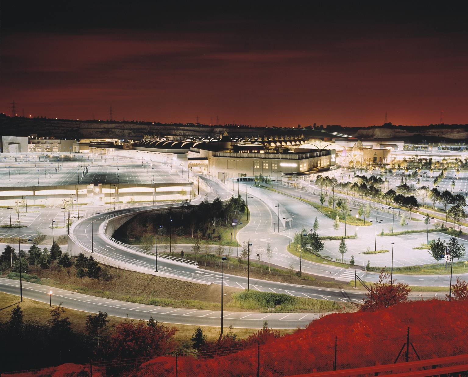
In the last decade the site has been of huge contention, with a proposed lorry park and Royal mail distribution centre looking to develop the brown field area, the guardian wrote about the developments and the work of the organization Buglife to seek protection and understanding of brownfield areas, and their vital role in our ecology.
West Thurrock Marshes, on the Essex shore of the Thames Estuary just west of the Dartford crossing, is a classic example of a brownfield site that has become of critically important refuge for endangered wildlife.
North Thames shoreline, Purfleet and west Thurrock
The Thames Gateway is one of the driest and warmest parts of the UK, and as such it has a unique fauna with many rare species. Two key flower rich habitats containing bare ground have now been largely lost from the Thames Gateway—upper saltmarsh and gravel grasslands. Sea walls, reclamation and saltmarsh erosion have squeezed out the dynamic upper saltmarsh habitats—areas of rarely inundated bare sand and mud, interspersed with ruderal and shrubby vegetation and a specialised insect fauna. This was once the habitat of the Essex emerald moth (Thetidia smaragdaria maritima), which after decades of hanging on at a few remaining sites was declared globally extinct in the 1990s. The gravel grasslands on the terraces historically deposited by the Thames were once sweeps of flower-rich, low nutrient, wild grasslands, buzzing with bees, wasps and other insect life. These areas have now been almost completely agriculturally improved or built on.
The power station at West Thurrock (now closed and demolished) produced a waste product known as PFA; this material resembles grey sand. The PFA was settled out in ponds on land neighbouring the power station. As these ponds dried out the sandy substrate was colonised by a range of species, including many rare and endangered species that occurred on the unique, but disappearing, local natural habitats.
West Thurrock Marshes (1990)
The 32 hectares of West Thurrock Marshes contains bare ground, flower rich grassland, scrub and saltmarsh and is one of the richest and most important wildlife sites in the country. It is home to 36 invertebrate species listed in the Red Data Book and 17 species of ‘principal importance’ for the conservation of biodiversity (UK BAP Priority Species). Threatened species include; the Brown-banded carder bee (Bombus humilis) and Red-shanked bumblebee (Bombus ruderarius), two of the greatly declined bumblebee species that depend on the large areas of flower-rich grassland; the Sea-aster colletes bee (Colletes halophilus) thrives on the abundant saltmarsh flowers; the Saltmarsh shortspur beetle (Anisodactylus poeciliodes) and the Fancy-legged fly (Campsicnemus magius), upper saltmarsh species that live on bare damp mud; the Five-banded weevil wasp (Cerceris quinquefasciata), which also requires bare sandy areas for nesting; the Hornet robberfly (Asilus crabroniformis), Britain’s largest fly and is a predator associated with animal dung; the Distinguished jumping spider (Sitticus distinguendus), only known in Britain from two development-threatened brownfield sites, and the rare Hump-backed red ant (Myrmica bessarabica), both the latter are restricted to sandy coastal habitats.
The only British sites known to be home to more rare species than West Thurrock Marshes are Windsor Great Park, an area of ancient woodland of the highest quality which is over 65 times larger and the unique coastal shingle habitat at Dungeness in Kent; both of these sites have been much more extensively surveyed than West Thurrock Marshes.
Early in 2006 a planning application was submitted for a huge Royal Mail distribution centre and lorry park on the northern section of West Thurrock Marshes. This would cover an area equivalent to 15 football pitches and destroy over half of the northern part of the marshes, including two thirds of the critically important flower-rich areas that support key insect species. Many rare animals could be lost from the land forever and the area of habitat available to all the species would be reduced: all this despite the fact that the site was designated for wildlife and open space in the local plan. Buglife—The Invertebrate Conservation Trust, alongside the local Council and Essex Wildlife Trust, pushed hard for a less damaging scheme to be developed, but in November 2006 the unelected Thurrock Thames Gateway Development Corporation approved the plans.
A motion was tabled in the House of Commons, calling for the protection of the site, which received cross-party support and in early 2007 Buglife met with then Prime Minister Tony Blair and the Biodiversity Minister to press for the site to be protected. But a political solution was not forthcoming.
Buglife initiated a judicial review to legally challenge the process that resulted in the decision. On the basis that the development runs counter to the principles enshrined by the Biodiversity Convention, and that in deciding to allow the development the Thurrock Thames Gateway Development Corporation failed to have sufficient regard for the biodiversity value of the site and hence did not properly apply the duty to ‘have regard to biodiversity’ that applies to all public bodies as set out in the Natural Environment and Rural Communities Act (2006). In addition, the Government’s planning guidance on biodiversity (Planning and Policy Statement 9 (PPS9)) sets out a series of processes by which planning bodies should make decisions. These include considering alternative sites if there is harm to biodiversity and ensuring that there is no damage to species listed as being of ‘principal importance’ for conserving biodiversity.
On 22 February 2008 the case went to court. The result was bad news for all wildlife, and not just the bugs of West Thurrock Marshes. Mr Justice Mitting dismissed the application to quash planning permission. In doing so he characterised the 2006 Biodiversity Duty as being a ‘weak one’, and gave greater weight to the statutory documents that underpin planning bodies. The judgment seemed to set a precedent that planning bodies do not have to follow national planning guidance on protecting biodiversity if this conflicts with a narrow interpretation of their regeneration role as requiring all land to be brought into productive commercial use, regardless of its wildlife importance.
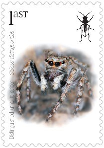
Endangered insects postage stamps, the Royal Mail printing these even as they’re building a new distribution depot at West Thurrock which will destroy natural habitats. top: Silver-spotted Skipper, Red Barbed Ant, Stag Beetle. centre: Noble Chafer Beetle, Barberry Carpet Moth, Purbeck Mason Wasp. bottom: Southern Damselfly, Field Cricket, Hazel Pot Beetle.
Undeterred Buglife launched a campaign to persuade Royal Mail to pull out of the development as a show of corporate responsibility. Ironically in April 2008 the Royal Mail produced a set of insect conservation stamps so Buglife produced a mock set of postage stamps based on some of the endangered species that the development would threaten.
Buglife made their own alternative stamps showing species threatened by the Royal Mail development
Dozens of letters were written to Royal Mail by campaign supporters. Initially Royal Mail refused to absolutely rule out moving onto to West Thurrock Marshes, but in August 2008 Dr Steven Boorman, Director of Corporate Social Responsibility at Royal Mail, said ‘I can confirm that Royal Mail will not be moving to the site at PFA lagoons at West Thurrock Marshes. We have found a more suitable site, which better meets our needs, in the area.’
However, the owner-developer Goodman International pushed ahead with their application for planning permission.
Buglife was awarded an appeal, heard in November 2008 the judges agreed that the Development Corporation had failed to properly consider alternative sites for the development, and had not followed PPS9 in a rigorous manner. However, despite this, the appeal was unsuccessful, with the judges concluding that the Development Corporation was entitled to rely upon a paragraph in a Natural England letter – which stated that the development offered the ‘possibility of a long term nature conservation gain for the area’ – as proof that the impacts of the development would not be significant, and that the development was therefore ecologically acceptable.
Buglife petitioned the House of Lords on the grounds that the Appeal Court should have applied a test of ‘anxious scrutiny’ rather than ‘benevolent construction’ to the decision to override the Environmental Impact Assessment; considering the environmental information in the round, and not allowing a single statement to negate the Environmental Impact Assessment. The House of Lords turned the petition down in May 2009.
In January 2010 Thurrock Thames Gateway Development Corporation granted planning permission on the reserved matters, but withheld the agreement of a phasing plan and assessment of the impacts of light pollution on the site’s ecology as additional planning conditions.
West Thurrock marshes: Refuge for endangered wildlife at risk, The Guardian (2010)
Buglife has since used extensive GIS mapping and field visits to survey all brownfield sites with the Thames Gateway Region, this took place between 2005-07
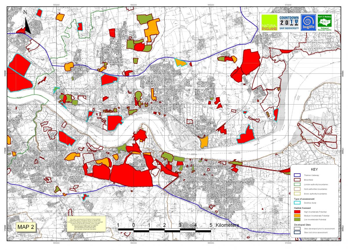
All of a Buzz in the Thames Gateway habitat assessment map, Buglife (2007)
and was revisited last year in their paper The State of Brownfields in the Thames Gateway (2013) , the following text is taken from their executive summary;
Buglife (2013)
Brownfield sites can be havens for wildlife, supporting rare and scarce invertebrates which have suffered population declines due to the loss of natural habitats in the wider landscape. However, brownfields are frequently targeted for development, despite many being the sole biodiverse green spaces in urban areas. Following the ‘All of a Buzz in the Thames Gateway’ project to map important brownfield habitat resources in the Thames Gateway, the dataset was revisited to quantify the rate of loss of sites valuable to invertebrates, since their assessment between 2005 and 2007. The 198 sites of High and Medium importance for invertebrates were categorised depending on whether the site was still intact, partially destroyed, completely destroyed or where planning permission had been granted and was therefore likely to be lost in the near future.
This review highlights that over a six-year period, over half (51%) of important brownfields within the Thames Gateway had been lost, damaged or were under immediate threat. The regional breakdown identifies that London has the highest rate of development with over two thirds (69%) of sites lost, damaged or with an outstanding planning permission. This report highlights that the planning system does not deliver safeguards for brownfield habitats and invertebrates of conservation concern, and calls for greater protection and consideration of their value. The rate of development on brownfields is highly unsustainable, putting rare and endangered species at risk of local or national extinction.
I have yet to take any photos within West Thurrock Marshes, as on the day I was there Network rail were carrying out clearance works as it is now the point that the high speed rail link exits from underneath the Thames. However due to the research I have read, I am keen to return and explore the site.
Lafarge works from the Queen Elizabeth II crossing, West Thurrock Marshes and pylon in the background
Further west along the river sits the Queen Elizabeth II bridge, and next to it is a Lafarge cement works.
Lafarge Works, West Thurrock, taken from Google Streetview
Another slipway juts out into the water to allow aggregates to be unloaded, for distribution around the UK. I realize that as I am now on the tidal side of the wall the path stops abruptly when it reaches the slipway security fencing, designed to stop people and contraband illegally entering the country without going through customs. My only option is to drop down the stone wall onto the foreshore and walk under obstruction. The shoreline is littered with flotsam and jetsam, plastic containers, rope, oil drums and most worrying a pushchair and child’s ride on tractor that is missing a wheel. As is often the case in these locations, I half expect to see a body washed up, but that is from watching too many films and tv programs.
The closer I get to the bridge the larger it becomes. You never get the scale when you are driving over it, trying to catch glimpses of the area around you, while trying to avoid going it to the back of someone else. In reality the space underneath it is monumental, a lift goes up one of the concrete pillars to the deck above, to allow for the current maintenance work. You can hear the vehicles booming overhead, amplified as the hit the metal expansion joints that separated the expressway from the bridge itself, thudclack, thudclack. The tide is out exposing the base of the pillars that sit anchored to the riverbed, surrounded by the thick Thames mud. I’m impressed to see that someone has tagged the base, no mean feat, being 30 metres past the shoreline.
Past the bridge the space opens out behind the tall security fence, just beyond it is the white funnel air intake for the tunnel below. I have seen it’s sister on the opposite river bank multiple times, it is often the last thing you notice as you drop below ground level. The Dartford side one sits within the complex of roadways and buildings that furnish the tollbooths. This side has none of that infrastructure, unkempt bushes surround it. It is the first time I have seen it, as you’re normally exit the tunnel with it at your back, unless the bridge is closed and traffic is being diverted under the river.
A warning siren sounds, lunch break is over and the overhead conveyor belt restarts at the next-door aggregate works. I continue along the Thames path towards the ferry port, a boat is moored at the end of the jetty, lorries trundle onto the waiting ship. I pass the battered and abused remnants of old wooden jetties, too worn to sustain traffic now.
The path drops down under the roadway above, the narrow tunnel is dark and flooded in the middle. I consider this a good point to turn round and head back to the car.
Map of Rainham MArshes, Peter Beard Landroom
Before returning to my hotel I decide drive along the new section of A13 and explore the new Ferry Lane industrial complex on the riverbank, just past the new RSPB Rainham Marshes. The location is split by the A13 flyover into a north and south site, it is currently sandwiched by the marshes and the Ingrebourne River. It is a mixture of older industrial units and giant new glass cubes housing companies like Tilda. The south side is were all the development appears to be happening.
Rainham Marshes (2013)
Rainham Marshes (1999)
As I drive down coldharbour Lane an man sits on the fence opposite one of the older units, a mug in one hand and fag in the other, clearly a response to the no workplace smoking rules. I do a quick lap of the territory in my white van, for once I don’t look out of place. Crossing under the A13, I am back into the familiar edgeland landscape of breakers yards, and transport cafes. The road carries on to the village of Rainham. While on the surface Rainham appears to be another small town/village, the reality is it is the furthest end of the unbroken mass of East London expansion, the only thing that keeps Dagenham, Hornchurch, Rainham etc from merging is the proliferations of small creeks and rivers running into the Thames that separate the conurbations for short periods.
We’ve been going to Rainham Marshes for a few years now – one of our favourite places. Since 2003 the architect Peter Beard has been responsible for a series of commissions for trail-making and interpretation of the site, along with designs for an educational field centre and a series of bridges connecting the nature reserve to the wider public network of footpaths, cycleways, roads and rail connections. The latest addition to this work is the magnificent ‘Trackway’, an elongated high-level walkway and cycle-path connecting the Rainham station pedestrian bridges (as well as Rainham Village) to the north-western corner of the marshlands.
Rainham Marshes, Jason Orton
The extensive site – consisting of Rainham, Wennington and Aveley Marshes – is a former collection of military firing ranges and ordnance depots, fringed on its perimeter by a landfill site, a housing estate, with the Thames to the south and a conglomeration of railway lines, electricity pylons, feeder roads, and breakers’ yards to the north. Yet the marshland itself appears as serene as Dutch painting in the midst of all this heavy and sometimes redundant infrastructure. Sheep and cattle graze, great flocks of over-wintering birds arrive and depart in formation, and the variegated colours of the tussocky grasslands, reedbeds, ponds and silt lagoons create a world-weary endurance of their own.
Rainham Marshes, Jason Orton
For the past couple of years Peter has concentrated on the north-eastern corner of the marshlands, north of the A13, an area which had been taken over by construction companies working on the adjacent Channel Tunnel Rail Link (CTRL). This area had been given a hardcore surface, which then had to be re-naturalised – but only to a degree. Scrub nature doesn’t take long to return. The interventions here have involved a series of semi-permeable footpaths and farm tracks, with boardwalks and bridges weaving a path through reed-beds and grasses, and across ditches and wetlands around the edge of the site, leaving the central marshlands free for grazing animals and colonies of nesting birds. The different boundary lines – grazing parcels, reed-beds, site edges and off-limits railway lines – are each given a distinctive fencing style, with chestnut paling, traditional iron estate railings, meshed-wire stock fencing, all slowly melding into the lush vegetation.
Return to Rainham, thenewenglishlandscape (2013)
On the way back to the hotel I drive down the expertly named Arterial Road, a truck stop catches my eye, “the arterial road has developed a way of life of its own with its ribbon-type development – villa, ‘caff’, garage, motel, caravan camp” Nairn, Outrage (1956).
Estuary English- West Thurrock, Simon Robinson (2012)
The two story glass box is named Circus Tavern and has signs outside for kickboxing events and Asian weddings, attached to one side of it is a flat roofed building, with signs advertising it as Tenshi Gentleman’s club.
Estuary English- West Thurrock, Simon Robinson (2012)
Estuary English- West Thurrock, Simon Robinson (2012)
Estuary English- West Thurrock, Simon Robinson (2012)
This is the first time I have spotted an edgeland strip club/truck stop; I suppose they have thought about there clientele. It is not quite as odd as the sex shop on the A1(m) just outside of Grantham, which is housed in a old McDonalds drive-thru. Whenever I drive past it I always wonder who drives down the dual carriageway and suddenly decides they need some instant pornography in their life?
Pulse and Cocktails, Stoke Rochford
The problem with staying in edgeland chain hotels is you are either compelled to eat in their own restaurants, which are always full of reps, whose lives are lived between the company car and chain hotel, single serving friends as Chuck Palahniuk described them in Fight Club. Or you try your luck at any of the identical chain restaurants dotted around the neighbouring units, however your choice will always inevitably boil down to burger, dirty chicken, or Italian (pizza). Had I been earlier in trying to find somewhere to eat, I might have tried to find the mythical Taco Bell housed somewhere inside the mammoth Lakeside complex, however as is often the case, I normally finish shooting pretty late, so in this case I went with the pizza option of Pizza Hut, which like all fast food restaurants was a mythical place when I was growing up, only witnessed on TV adverts. Thank you Mum and Dad, for saving me from terrible overpriced food.
The good thing about a large pizza is you can always take some back for you and have an easy breakfast, when you are exhausted from a terrible nights sleep in a strange bed, and sore from lugging a stupid large format camera around all day. While I was driving around trying to find somewhere to eat, I saw that beyond Lakeside, as you start to hit the smaller commercial units is a lot of life late at night, local lads with their souped up hatchbacks, parked up and admiring each others rides. A double decker bus, lit up with blue neon sells burgers to the crowds. I get some awkward looks as I slowly cruise by in my van, but it is no more aggressive than Yarmouth seafront on a Saturday night, and everyone is too busy chatting to really notice me.
The next morning I wake up to find the whole Thames Gateway covered in thick fog. The newspaper and clean air lobby later refer to it as terrible smog, but it is no different to any other fog I have experienced, rolling off the cold Thames. It reminds me of the opening of Dicken’s Great Expecations.
It was a rimy morning, and very damp. I had seen the damp lying on the outside of my little window, as if some goblin had been crying there all night, and using the window for a pocket-handkerchief. Now, I saw the damp lying on the bare hedges and spare grass, like a coarser sort of spiders’ webs; hanging itself from twig to twig and blade to blade. On every rail and gate, wet lay clammy; and the marsh-mist was so thick, that the wooden finger on the post directing people to our village—a direction which they never accepted, for they never came there—was invisible to me until I was quite close under it. Then, as I looked up at it, while it dripped, it seemed to my oppressed conscience like a phantom devoting me to the Hulks.
I check out of the hotel and decide to head back down to the waterfront to see how it has changed in the weather conditions, if it is still the same county that Dickens and Conrad wrote about. I stop halfway back to the church and look at the new bridge for the high-speed line, appearing out of the mist.
You can’t make out the Lafarge works or QE2 Bridge in the background, but you can still hear its constant wail. It is easy to understand how people used to get lost in the marshes; distances and sounds start to play tricks on you, without way makers you get turned around. I set up under the rail bridge, the trains whooshing overhead. The new concrete construction appears to have been dropped down onto the pre-existing landscape, leaving small voids under and around it. I work to cantilever my camera through the gaps in the fence panels, the tripod at a weird angle and the front standard propped against the galvanised metal.
As I’m working I notice that all the lorries pull out of the BP depot, and park in a layby round the corner, each spends around 10 min have a cigarette, checking their cab and reading the paper. I consider asking each of them if I can take a quick portrait of them in the cab, but I only have the monorail camera, plus speaking to to people who approach you is one thing, I’m still not ready to approach strangers and certainly not truckers, if the media has taught me one thing it is that they are strange. As the fog start to burn off it takes on a nicotine colour as the sun tries to break through. It might be time to move on, and I agree with myself to cross the river and head to St Mary’s, but first a stop to look at the new builds I could see around Swanscombe from the river bank the day before. A quick check of my OS map shows that I need to head to Greenhithe, the new development is clearly visible for its contemporary jaunty road layout, sitting next to the chalk cliffs that sit below Swanscombe March.
After paying my £2.50 to cross the Thames at the toll booth, I almost immediately have to take the left junction, swinging back on myself on the exotically named Crossways Boulevard, as usual some clown cuts me up, clearly unaware that junction was so quickly after the toll. This happens every time I come to this section of the Thames. Crossways Boulevard is the main route from Bluewater to the Dartford Crossing, and hugs the contours of the Thames, with new business parks on either side and a series of ponds dotted around its roundabout system.
I come to a roundabout and the road sharply turns to my right heading towards the shopping mall, I take the first left and head into Greenhithe. Greenhithe was once a small hamlet, but little of this appears to remain, and now feels like any other waterside overspill estate, a collection of red brick semi detached houses and newer waterfront flats. It had a brief spell of popularity with the Victorians after the building of a now gone pier, and was the local maritime school housed the Cutty Sark from 1938 till it was given to the National Maritime Museum after the end of the second world war.
A series of blue fencing and advertising hoardings lead me to Ingress Park, a development that appears to have doubled the size of Greenhithe and was one of the few developments ot actually happen under the New Labour Thames Gateway scheme. The town houses drop steeply down the hill towards the Thames foreshore, as the estate curves round to my right it opens up into a wide formal lawn with the grade II listed Ingress Abbey at the brow of the hill.
Introducing Ingress Park; a stunning development of new homes in Greenhithe, Kent by Crest Nicholson. Set amongst 72 acres of landscaped grounds on the River Thames, near Bluewater, this desirable residential development is known to locals as Kent’s ‘best kept secret’.
Designed and set around the historic abbey with its waterfront, established parkland heritage and woodland areas, this development of new homes in Greenhithe delivers on its promise of a strong sense of place and community. Our current phase of new development The Pier introduces a contemporary collection of 1, 2 & 3 bedroom apartments and penthouses overlooking the River Thames.
Ingress Park is perfectly placed with easy access onto the M25 and A2, and within walking distance of Greenhithe station. It is also just a short drive from Ebbsfleet International station with direct trains to London St Pancras in just 17 minutes.
Crest Nicholson’s promotional material
The building and layout reminds me of Port Merion in North Wales, and not in a positive way. It feels very much like the fake rusticity that Ian Nairn spoke of, simply updated for the 21st century. I take issue with the name. I understand that the site is named after Ingress Abbey and attempts to buy into the history of the site, but all I can think about is people discussing the ingress of water and mould into their properties, the word has too many negative connotations. They would have been better of naming it Empire Park, after the Empire Paper Mill that stood on the site in a previous lifetime.
Empire Paper Mills and Ingress Abbey Wharf, Greenhithe, (1927)
Empire Paper mill (1960)
Empire Paper Mill (1990)
In the 1880s, the Shah of Persia sailed up the Thames and noted that “the only thing worth mentioning at Greenhithe was a mansion standing amid trees on a green carpet extending down to the water’s edge”, and that is how I feel now.
The strangest aspect of Ingress park is how some of the original topographical elements have been preserved and utilised within the masterplan. At the centre of Palladian Circus is a Tudor earth mound, that once apon a time was probably very pleasant, set amongst the grounds and trees. Now set in the middle of the rotund of town houses it looks like a strange helter skelter, and bares an uncanny resemblance to the tree topped hill in the London 2012 opening ceremony, complete with standing stone.
Palladian Circus, Ingress Park, taken from Google Streetview
Palladian Circus (2013)
The problem with any new estate is the planned nature of it. We like our villages to look higgledy piggledy and a collection of buildings that have happened over time. Planned developments don’t have this luxury and have to work as planned phases. Various pieces of writing about the development only reinforce my negativity towards it.
The architects of the first phase at Ingress Park took their inspiration from the Grade 2 listed abbey. With sustainability as a priority from the outset, any materials that were recyclable were to be incorporated into the new development. For example, old timbers from demolition were used for street furniture in the new development. An important consideration was to ‘create a real sense of place and not a Disneyland of distinct themed villages’ (Fraser Stewart). This was achieved by a subtle range of architectural detail and a restrained palette being used throughout.
CABE case study into good design
We visited the brownfield site to see the new semi-urban vernacular in action.
When Crest Nicholson was deciding what type of housing to build on its brownfield site in Greenhithe, Kent it found little locally to inspire them. “There are a few gems but not a lot,” says Crest Nicholson strategic director Steve Atkins. “Existing housing stock in the area relates to the industrial past; there’s a lot of back-to-back terrace housing,” he says.
Ingress Abbey, and the new builds of Ingress Park
The one clear reference is the Grade II Ingress Abbey, which survived the intervening hundred years of industrial development across the site on the banks of the Thames. Architectural references from the mansion house can be seen in the first phase of new homes at Ingress Park, which is one of ten character areas to be developed in the next two-to-three years. Gables, render and stone architraves are some of the features that borrow from the abbey.
For further inspiration Crest and Tibbalds TM2, the masterplanner and architect, undertook study trips to nearby towns and villages to develop a feel for the north Kent vernacular. The design team included representatives from Dartford Council, which has helped to smooth the planning process for the 900 homes, says Atkins.
The design team were widely influenced by Victorian and Edwardian terraces, which fitted in with an earlier decision to build at a high density. And because of the open book discussions with the planners, the council was also happy with this route. “Part of the agreement was that we would deliver quality in return for density,” says Atkins.
Atkins’ architectural gems are in Greenhithe’s village centre, which contains a variety of Kent house types. These buildings will mostly be reflected in the Village Quarter of Ingress Park, which will sit next to the old village at the waterfront. Materials may include weatherboarding and knapped flint, but Atkins says that some local materials are no longer readily available. As a result materials such as Kentish Rag stone and flint will be sparingly used.
The housing won’t be entirely traditional. There will be an opportunity along the riverfront to be more contemporary, says Fraser Stewart, director at Tibbalds TM2. These homes will still be in keeping with the overall tone of the development. “The integration of detail is important,” he says.
The architect was keen to maintain contiguous terraces, because it believes that it contributes to a more attractive streetscape. The mix of arches, balconies, dormer windows, bespoke garages, bays, gables, orangeries, and different materials also adds drama and ensures a rich variety of housetypes (over 50 in the first 100 homes). “It’s about identifying architectural embellishments that give the townscape value,” says Stewart.
Atkins says the investment in architecture is worth it, particularly in the first stage. “We are setting out our stall. We needed something new that raised the tone and attracted key buyers,” he says “There are competing schemes nearby and our first phase is near the main road which gave us the chance to stand out from the crowd.” Stewart says that quality housing is more important on brownfield land. “If a location is uninspiring the homebuilder has to pay more attention to the architecture in the first instance.” Although the site has been used for industrial processes for the last 100 years, the development of Ingress Park still had to be handled sensitively. Capability Brown had a say in the original landscaping and as well as the Grade II listed house there are seven listed Victorian follies. Atkins says that by working alongside the project the planners could see the amount of investment Crest was putting into the building and restoration of the land. As a result of Crest’s work, which included spending £6m restoring the Abbey, the council is only demanding 10% affordable housing.
According to Stewart, Kent County Council is using Ingress Park as the blueprint for all future developments. This will presumably apply to Crest’s next development in the county. It has bought land on the peninsula next to Ingress Park and is planning to build up to 3000 more dwellings, which will use the 40 000 sq ft of retail planned at Ingress Park.
What makes a streetscene?, Building.co.uk (2001)
Palladian Circus, Ingress Park
While the devolpment has one many awards and plaudits, it hasn’t had it all it’s own way, The Telegraph questions it’s legacy
When wealthy barrister James Harman built his Elizabethan mansion, Ingress Abbey, on the banks of the Thames Estuary, at Greenhithe in Kent, in 1833, he hoped it would become the hub of a villa civilisation to mirror the one lining the Thames between Kew and Richmond.
His architect, Charles Moreing, worked his way through the then enormous sum of £120,000, constructing turrets and crenellations of reclaimed stone from the old London Bridge and Houses of Parliament. The Capability Brown gardens, left over from a previous incarnation of the Abbey, were enriched with follies, grottoes and hermits’ caves.
Then Harman moved in, waiting for others to see the potential of this richly wooded river buff, the first close-up view of England that foreigners had as they sailed into London. He could not have got it more wrong. It was not villas that started popping up along the coast but factories, cement works and, eventually, oil refineries.
Greenhithe (1960)
By the early 20th century, Harman’s descendants had given up the unequal struggle. They sold off a large part of the grounds for development into the sprawling Empire Paper Mills. The rest of the gardens was left to go to seed and the house was allowed to fall into decay, while around it sprung up the grim, beton brut blocks of the Thames Nautical Training School.
Harman’s ghost has had to wait another 100 years to see the area finally begin to go up. A villa civilisation of sorts is emerging along the Thames Estuary, albeit a rather more mass-market one than he had in mind. With heavy industry in decline and “brownfield development” as one of the great buzzwords of our age, the eastern flanks of the Thames have been declared the nation’s single largest residential expansion zone – the new Thameside linear city as foreseen by Michael Heseltine in the early 1990s when he was Environment Secretary.
If you want to buy a new house in the South-East in the next decade or two, it may well have to be along the Thames estuary. The flanks of the Thames have been projected to absorb more than 100,000 new homes in the next 20 years, accounting for one in eight of all new houses in the South-East.
Welcome to Estuary England, home of the Ford Escort Cabriolet, the glottal stop and now the mega housing estate. Unless you already live here, the most you are likely to have seen of the forthcoming Thameside city is in a hurried glance from the Dartford Bridge, as you fumble around for a £1 coin for the tollbooths.
Dartford Crossing
Save for a misty day, when all you can see is the silvery water of the Thames itself, it does not at first look exactly inviting. There are oil tanks, container parks and cranes as far as the eye can see, while two of the world’s largest pylons carry the national grid across the Thames. Were there still a Shah of Persia to sail up the Thames, he might be tempted to turn back, concluding that Britain was beyond redemption.
Yet, somewhere, among the industrial litter are the first signs of improvement. Along rotting wharves, which not so long ago had intrinsic joke value, the first townhouses are going up.
Greenhithe High Street, a surprisingly pleasant backwater of 18th-century fishermen’s cottages, was, until recently, buried beneath the soot and ash of heavy industry. Now, it has become the heart of a little riverside community. Though the new houses on the quaysides are of indifferent quality, the wonder is that people have been persuaded to live there at all.
But the most promising sign of regeneration is the rejuvenation of Ingress Abbey. Once again, a green carpet stretches down to the Thames and, for the first time in more than 100 years, the house presents a clean façade.
There is a cost attached to its restoration: in return for the £6 million it has spent restoring the house (which it has sold to a technology company as offices for £2 million), Crest Homes has won permission to fill Capability Brown’s former 75-acre gardens with a whopping 950 homes.
It is the kind of deal that is becoming increasingly common, as heritage officers seek to have endangered buildings restored at no public cost and planners try to squeeze building plots out of every last inch. And it is a deal with which, given the state of the park just a couple of years ago, it is difficult not to find sympathy.
Ingress Park (2003)
Aerial photographs taken in the mid-1990s show the paper mills as an ugly mass of dirty brick, prison-like buildings and the rest of the site, while retaining many of the trees, is unkempt, spoiled by former chalk-workings. Now, a formal avenue of trees, reminiscent of a Parisian park, leads down to the Thames. Soon it will be joined by a riverside walkway and paths through the woods.
There is also a quality that was absent from mass-market developments until recently: the kerb-stones are granite, the pathways in a warm gravel. The houses, too, are a new departure for estuary England, where the mock-Tudor window and the neo-Georgian plastic pillar – often used on the same house – have ruled. Mock-Tudor hasn’t been abandoned but, in keeping with Harman’s original villa, it has been taken upmarket.
Ingress Park (2005)
It is an environment to which many new home-buyers may find it takes time to adjust. Gone are the sweeping driveways for three family cars which, until recently, buyers believed they had a right to expect. The Thames Estuary is at the frontier of the brave new world of PPG3 – the name of the Government document that obliges local authorities to increase the density of new developments.
At Ingress Park, the traditional developers’ practice of building 12 to 14 houses to the acre has been dropped in favour of 25 to 30 houses to the acre. That means a home for every 1,500sq ft. You do not achieve this sort of density by building detached houses in landscaped gardens. “That’s the closest you’ll find to a traditional house on the whole development,” says Crest’s development executive Steve Atkins, pointing out a detached, rectangular home.
The majority of the development will be three-storey terrace townhouses with parking underneath. “We’re putting in balconies and roof gardens to make up for the fact that the houses won’t have large gardens,” adds Mr Atkins.
Ingress Park (2013)
Developers, bless them, have been only too keen to adhere to the Government’s campaign to save the countryside by building homes at ever-higher densities. Mr Atkins goes on at some length about how impressed the planners were that the site’s masterplan obeyed the strictures of PPG3, but omits to mention that squeezing in more houses to the acre might suit the developers’ interests, too.
With more Ingress Parks, Estuary England could lose its reputation as a showcase for all that is ugly about modern Britain. But it is when you leave the development that you wonder whether the new Thameside city will be quite the paradise that the planners’ blueprint forsees.
A Machine for Living: Untitled, Dan Holdsworth (1999)
A mile away lie the sprawling car parks of the Bluewater shopping centre. The high-density of the housing is mocked by its low-density distribution and and by the vast gash in the Downs that is the Channel Tunnel Rail Link and the ever-spreading lanes of the A2/M2. You have to ask whether we have got it the right way round: people are made to live hunched up on brownfield sites, while commerce and road and rail projects are granted every acre of greenfield land they demand.
One wonders what poor Harman would make of his neighbourhood. South East Living: Paradise found, lost – and regained? The Telegraph (2001)
The real issue with the estate is the lack of infrastructure, being built by private developers they increasingly think of the bottom line before the needs of the communities they are creating or the impact it will have on the pre-existing ones. Greenhithe was a small village before the Thames Gateway initiative started, it schools, doctor surgeries, leisure facilities were not designed to cope with a doubling in size.
Greenhithe (2014)
At the crossroads of all this building work is St Mary’s Church, from where Reverend Richard Barron has an uninterrupted view of the ever-changing landscape. He is saddened by the failure of developers to meet the needs of the growing local population. “There is nothing that has been built for the community in the last ten years. It’s a though the community has been by-passed. Things like playing fields, places where children can let off steam, doctors and medical facilities.
“There’s a lot of talk, but when it comes to social cohesion – it’s not there. People have to go elsewhere for leisure and pleasure, which is getting away from a socially sustainable community because they’ve got to get in their cars and go somewhere else.” A local resident describes the promise that developer made to the local community, “Things like doctor’s surgeries and schools that were promised have never materialised. It’s now more of a dormitory area, just a satellite for London”.
Thames Gateway before urban sprawl
The city is to-day not such a growing as a spreading thing, fanning out over the land surface in the shape of suburban sprawl. However something even more sinister is at work: applied science is rendering meanigless the old distinction between urban and rural life; the villager is becoming as much a commuter as the citizen.
Ian Nairn, Outrage (1956)
Thames Gateway (2013)
Terms like satellite towns and overflow areas keep popping up when describing the Thames Gateway. If you look at maps from the start early 20th century compared to now you will see that all of the small villages and hamlets have been swallowed up by the east end of London, leaving one continuous band of urbanism. Developments like the high-speed rail link have made journey times into the city even shorter for those that can afford it, meaning the reach of the London Commuter belt has become further. Suddenly places well outside the M25 belt have become satellites of London. It takes me an hour to get into Central London from Epping on the central line, the journey from Ebbsfleet on HS1 is 17 minutes, while from Chatham it is 40min. Housing prices within London as ridiculous, so we push the reach of London further afield, great if you work in the city, but what happens to the old communities that these developments are displacing?
After leaving Greenhithe and driving through Ebbsfleet, my journey takes me down the new section of the A2, strange pockets of land exist between the new road and old Watling Street, which up until a few years ago was the original course of the A2.
the new A2 and the old A2 (Watling Street)
Cafes, petrol stations and motels sit idle, many boarded up, unable to sustain themselves now that they are marooned from passing trade by the immaculate greenery of the highways agencies new soft estate.
Toll Gate Inn after closure in 2011, Gravesend
Toll Gate Inn, Gravesend
Like Robert Maitland in Ballard’s Concrete Island they are marooned within sight of salvation, “alone in this forgotten world whose furthest shores were defined only by the roar of automobile engines… an alien planet abandoned by its inhabitants, a race of motorway builders who had long since vanished but had bequeathed to him this concrete wilderness.” The reality is very few will stop to explore these locations, barely see, seldom acknowledged as they are whisked down the road, 70mph, onto the destination, always the destination. The roadway a metaphor for our understanding of the urbanised world, everything is now bypassed, cant step of the path for fear of becoming lost, places fall off our internal maps.
I finally get to Chatham to start taking photos by the early afternoon. It has taken me half the day, but I feel richer for having stopped and explored along the way. Locations I intend to revisit now I have a feeling for them.
Last time I wrote about Sheffield was when I started using my sound recorder for the first time, following the River Don and through the deserted streets of Attercliffe. At the time I hadn’t developed the film I took on that trip, and have been looking for a way to write about it since then, that didn’t simple involve uploading the images.
The last month has seen some of my favourite sports on the television, the Hockey World Cup, and the Cricket Test match, however my favourite sport at this time of year for the shear spectacle of the level of endurance is the Tour de France. Every year, for a two-week period the house is alive with words like peleton and Maillot Jaune (all of which my 23 month old daughter is now picking up). However, this year for the first time in a while the Tour set of from the UK, and the second stage culminated in Sheffield.
When I sat down to watch the final section of stage two, I had no idea of the route through the city. So I was suddenly surprised to see a building with sign saying Bronx on it.
Bronx, 208 Saville Street East
I had been past this building on my first sound walk around the city. The building is a former pub named the Norfolk Arms, after the Norfolk Steel works that stood behind it until the late 80s.
Norfolk Arms, 208 Saville Street East
In it’s prime the Norfolk works covered a 15 acre site
Norfolk Steel Works
The Atlas and Norfolk Steel Works, Sheffield, 1947
Russian Targeting map 1980s
A Christmas reverie 3. Atlas works. This is 1987 and shows the demolition of the massive Atlas Works. Adrian Wynn
Site of Norfolk Steel works 1993
Very little remains of the Norfolk works now, except for the entrance way to one of the former melting works.
The gateway of Thomas Firth and Sons Ltd., Seimens Melting Shop of Norfolk Works
and the former site medical centre, that was explored by the urbex group 28dayslater in 2010.
A couple of weeks back, whilst visiting Megatron, AEM told us about this undergound place he had visited, sadly we ran out of time on this occasion. After looking through his photo’s I was intrigued, and decided this ‘a must see’.
There isn’t much info kicking around about this place, however I did hear that it was linked to Firth Browns Steelworks. This place is truly a hidden gem, and now sadly buried below a car park with no obvious signs of what lies beneath.
Just a small place, but an early insight into a long demolished factory. It’s difficult to work this place out, whether it was above ground, or covered over with earth by design, or covered over post demolition. It’s not strictly ‘underground’ in that it wasn’t dug out of the earth. We’ve since been told that there may be more to find in the vicinity, hopefully the locals will get out there and find it… “there was a canteen beside it, an ambulance station (he thinks the entry on the roadside is bricked up) and, believe it or not, a rifle range”. You never know.
an amalgamation of posts from, Underground medical centre – Sheffield – 28dayslater (2010)
I had always assumed from the shape and name of the building and it’s position that it was now a dodgy nightclub, when I did some research to find an image; I was surprised to discover it’s real use. Their website describes it as Yorkshire’s only gay and bisexual sauna.
Coming from a conservative background, and as someone whose gay friends are not to my knowledge into this niche aspect of the lifestyle, I didn’t even know these places existed. I was even more surprised that it was situated within this (post)industrial/edgeland environment. At this point I didn’t know about Attercliffe’s reputation, while it has many adult shops, I hadn’t been aware of it’s gay and underground club scene. I assume though that it is partly due to its position far enough out of the city centre to avoid grief on a Friday and Saturday, from any local hotheads. A legacy to when the gay community wasn’t as welcome in society as they now are.
As the peloton rolled past the Bronx, next up on the left hand side was a Costa Coffee, situated within a disused Victorian building, that I had gone into, soaking wet in my scruffy hiking gear, and with a huge camera bag and heavy Manfrotto tripod. I suddenly realised as the camera bike carried on that we were about to go past a nondescript black gate set in a stonewall. ‘That’s the gate I jumped’, I exclaimed to my wife and daughter, ‘look on the right hand side, that’s the main cop shop for the area, I can’t believe no one saw me nip over the wall’.
I had spotted the area on the other side of the wall, during my first walk down the river, but from the opposite bank. From that spot I could see the elaborate graffiti under the railway bridge, and from this I knew that the site had to be accessible on some level.
When I got back to Norfolk I checked it out on the OS map I bought at Meadowhall. It showed the weir and a short tributary running off the main stretch of the Don. You could clearly see the railway bridge and a small pocket of white space either side of the bridge and water, divided off from the main road by a boundary.
A quick check on Google street view confirmed that there was access to at least one side of the bridge. At this point I agreed with myself that it worth a visit with a film camera the next time I was in Sheffield.
At a recent symposium on Art and the Edgeland, held at Exeter University during the Easter break, we discussed a couple of points based around access to these sites, the first being the physical access to locations. I started my real photographic career during my third year at Falmouth, working on a body of images based around the disused asylums within the M25 belt.
Cane Hill- from the series, Darkness on the Edge of Town, Simon Robinson (2005)
Cane Hill- from the series, Darkness on the Edge of Town, Simon Robinson (2005)
Meeting fellow urbexers you quickly learn that trespass is only a civil offense, and not a crown one. You can be taken to court by the landowner, but not arrested by the police. This is unless it is aggravated trespass, ie you have already been asked to leave and refused, or you are causing or have caused criminal damage while gaining access or once at a location, (please don’t take this as letter of the law, if in doubt look it up on legislation.gov.uk).
So in reality you can choose to hop a fence with limited chance of any legal ramifications, personal safety etc. are all your responsibility to act in an intelligent manner. For more information on urbex, plase read Dr Bradley Garrett’s book Explore Everything: Place-hacking the City (2013), as well as his article in the Times Higher Ed, for when it does go all wrong, Place-hacker Bradley Garrett: research at the edge of the law
The second point we discussed was surrounding the limitations of a traditional map. Thinking about aerial roadways, flyovers, bridges etc. When you look at a map
Site of Folly for a flyover, the road used to be classed as motorway and would have appeared blue on the map.
you can only see the thick blue line of the motorway. It is only by being there, inhabiting the space that you can start to experience what lies beneath the roadway.
The example we looked at was a pop up architectural space in a motorway undercroft. During the summer of 2011, an ugly and unused plot beneath a motorway flyover close to the Olympic Park in east London became home to a temporary cinema and events space built by architecture and design collective, Assemble.
Folly for a Flyover was a temporary project that demonstrated the potential for a disused motorway undercroft in Hackney Wick to become a new public space for the area. For 9 weeks, this neglected and unwelcoming non-place was transformed into a host space for local residents and visitors alike – attracting over 40,000 visitors in the course of one summer.
Beneath the massive concrete beams of the flyover a simple bank of seating descended towards the canal that runs along one edge of the site. A core of scaffolding supported the stalls and the adjacent structure, which mimicked the brick buildings of the local borough but was merely a cosmetic frontage for the café and events spaces. Construction was completed in a month by a team of volunteers using locally sourced materials, including wood and clay bricks that were removed and reused locally once the folly’s brief occupation had ended.
The Folly invested the site with a positive future by re-imagining its past – posing as a building trapped under the motorway. Its roof pushing up between the East and Westbound traffic above, Folly for a Flyover hosted an extensive programme of waterside cinema, performance and play delivered in conjunction with the Create Festival, the Barbican Art Gallery and numerous local organisations and businesses. By day the Folly hosted a cafe, workshops, events and boat trips exploring the surrounding waterways. At night audiences congregated on the building’s steps to watch screenings, from blockbusting animation classics to early cinema accompanied by a live score.
I could see from the maps and street view images that the site by the River Don was accessible and had photographic potential, but it wasn’t until I jumped the wall that I could actually understand the space.
Just through the gate a small disused path dog legs to the left, through small trees and shrubs, on the right hand side is a pile of ballast, that has clearly been sitting undisturbed for some time, as the grass and moss has started to recolonize it. Empty bottle and beer cans litter the site. The path carries on for 10 metres before opening up as I get close to the bridge for the first time. The stream that I could see running off the Don is on my left hand side, covered with silver birch, that over hang it slightly. A large clump of bulrushes sit in the water, and as I catch sight of the dark pool under the bridge, as it appears through the trees and rushes, I am startle as a heron takes off, huge and pterodactyl like.
Under The Bridge- Downtown, Simon Robinson (2014)
Underneath the bridge itself is a slimy pathway, about 1 metre wide, the ground is slick with moss and soft silty mud, the water has a oily metallic sheen in places, and is covered in a milky white scum. The graffiti that I could see from the opposite side of the river is on one of the bridge walls, while on the other is another piece, a black and white tribal figure, with a spear lodge through the tail end of a giant fish. The graffiti is one of many in Sheffield by the local born artist Phlegm.
Hunter Gatherers by Phlegm, Simon Robinson (2014)
The pool itself is formed by a metal flood gate damming the water supply, barrels and tree debris sit half submerged in the shallow liquid, the muddy surface, threatening to suck them in. over the flood gate is a rusty metal walkway to allow access to open and close the gate. I decide to risk crossing it with my heavy bag and tripod. After placing a foot tentatively on the dark ochre chequer board, I am convinced that it will support my weight. It doesn’t start to feel dubious till I’m half way across and a feel a slight increase in the bounce underfoot, nothing concerning but certainly noticeable.
Flood Gate, Simon Robinson (2014)
The other side of the water opens up in the lee of the railway embankment. I come out into the small void of white space I could see on the map.
It is covered in bracken and brambles, I venture closer to the rivers edge, the stagnant pool to my back. As I walk other the covering on bracken I realise the ground is increasingly squishy underfoot, I am standing on a semi solid void between the bank and a brick casing holding back the embankment from toppling into the river, which is a three metre drop below.
I quickly take my photo. It isn’t the worst situation I have been in while trespassing, that still is held by standing on a small section of the second floor of a burnt out ward in Cane Hill asylum, that I realise once I packed my camera away was a honeycomb of holes, with a thin layer of rubble on top and nothing below until the foundations under the missing first and ground floors.
Cane Hill- from the series, Darkness on the Edge of Town, Simon Robinson (2005)
This doesn’t even come close, but still feels suspect. I have a more pronounced feeling for personal safety since the birth of my daughter. While standing there, a group of people walk down the other side of the riverbank. They are from a local community group cleaning up the debris flushed down the river from recent heavy rain. They look confused to see me, but wave anyway. Most people assume you are supposed to be there and don’t bat an eyelid.
Worrying that my time might be cut short I cross back over the floodgate, stopping half way to photograph the pool. On the other side of the gate is an area were flood debris has collected, silting up the water to a point that it is solid enough to stand on. The water starts again five metres beyond this point. I clamber down, intent on taking a photo. A makeshift fence of corrugated metal, topped with trident spiked galvanised security fencing and razor wire separates the space from the breakers yard next door. A blue metal post, supporting the corner of the improvised wall, holds up my side, a pile of tires sits against the other side of the fence from me.
Tyres, Simon Robinson (2014)
Just next to it is one of the many storm drain grates, large round metal doors holding back the escape of water from the sewage system, waiting to be opened if the weather turns biblical. The water that I have come to photograph is beautiful, and surrounded by green foliage, juxtaposed against the shipping container and fencing. A sign barely visible is attached to the back of the container, a legacy to its previous life on another edgeland site; I can make out ‘Twines, Wiper, Load, Rope, 77321 for service’. I wonder who was the last person to read the sign, or call the number for service; no one is going to see it here.
Twines, Wiper, Load, Rope, 77321 for service, Simon Robinson (2014)
I finish making my images just as the rain starts again, sheltering under the bridge I listen to the birds, the water dripping from the iron work above, splashing with a plop into the now disturbed water below. A train thunders over head, deafening, and break the semi-peace of the location, the traffic continues beyond the tree line, a constant wall of static that until I pause to listen to, I haven’t been aware of. I pack up my camera bag, happy with the roll of 120 that I’ve shot, and venture back out in the world beyond the trees, descending on the Costa next door.
Further down from this void of space, is a larger pocket of trees and tracks, seemingly inaccessible trapped between the railway tracks and scrap works. As of yet I haven’t come up with a plan to access it, but hope to return on a future trip.
The Tour de France continues along Brightside lane, past the Police station and Royal Mail depot. It hits the roundabout in front of Forgemasters steel works and swings up the valley towards Jenkin Road, or Côte de Jenkin Road as it will now most certainly be known.
Jenkin Road begins just outside the local steel foundry, the sort of area where you find discarded hubcaps at the kerb. Painted on the surface, along with the names of cyclists, are the names of people who live there: “TEESH”, “KATH”, “SHAZ”.
Up it goes, past Brightside Post Office, past the Nisa corner shop, past Chafer’s decorators, eventually coming to an elevated end in the shadow of some smart but unprepossessing 1920s brick houses. Round the corner is the boxing gym that turned Prince Naseem Hamed into a champion. An Arctic Monkeys song pumps out of some speakers. I try to imagine Jacques Anquetil or Luis Ocana puffing their way up here back in the day, and for once my imagination fails me.
Think of Le Tour, and its classic peaks pierce the mind. The verdant and regal Tourmalet; the scree-flecked wilderness of the Galibier; the snow-capped moonscape of Mont Ventoux: all as pleasant to watch as they are unpleasant to ride. But on Sunday, the humble suburb of Wincobank in east Sheffield wended itself into the Tour’s rich heritage. With a maximum gradient of 33 per cent, Jenkin Road or the Côte du Jenkin Road – is the steepest section of this year’s race.
There is a reason the second stage had been described as Yorkshire’s answer to the Spring Classics, a course to rival the Amstel Gold Race or Liège-Bastogne-Liège. There is a Belgian-style inconsistency to the landscape. It is not so much the severity of the climbs, but their relentlessness. There is a barely a moment to catch your breath before the next upward slog. And Jenkin Road, placed just three miles from the end of a long and gruelling stage, represents nothing less than half a mile of pure pain. It is a short but brutal climb, a residential road so treacherous that there are railings along the pavements for pedestrians to keep their balance.
At which point it is natural to engage one’s sadistic side, and congratulate Christian Prudhomme and the organisers for yet another magnificent piece of routing that again ripped up the rulebook. Second stages are not meant to be as brutal as this. Hills should look like hills. Climbs should be death in paradise, not murder in suburbia.
Why would anybody make a road this steep? And why would anybody live on it? “You should see it in winter,” one resident calls out from her front garden. “Some days it can be snowing here and not at the bottom. They didn’t tell me that when I bought it.”
There is a YouTube video of Marcel Kittel, yesterday’s yellow jersey, riding up the hill a few months ago with John Degenkolb and his other Giant-Shimano team-mates. By the time he is halfway up, it is clear his main objective is not so much moving forwards as trying to avoid moving backwards. “This stage is super hard,” Degenkolb told ProCycling magazine afterwards. “The final result in Paris will not be decided on these roads, but it will surely lost by some because they are very dangerous.”
And it was the prospect of high drama on the high slopes that brought as many as 60,000 people to the roadside on Sunday. Before the race, Chris Boardman had picked this out as the most important segment of the stage, the place where attacks could be made and decisive time gaps could develop. And the words “Shut up, legs” painted on the road were a portent of the brutal ordeal that awaited.
Those with pocket radios had kept us apprised of progress. And as the whirr of team cars and police sirens got ever closer, a whisper spread through the crowd. “Is that him? It’s him! Froome’s in the lead!” The roar was colossal as bike No 1 led the pack up the hill. Froome looked calm, untroubled. So too eventual stage winner Vincenzo Nibali behind him. But as the frontrunners receded into the distance, the mood of those following was subtly different.
Fabian Cancellara went past, grimacing like a man undergoing an unanaesthetised vasectomy. Brice Feillu’s mouth hung wide open, as if breathing for the last time. Niki Terpstra looked deeply unimpressed, like a man who had just locked himself out of the house. Sylvain Chavanel chuckled a rueful chuckle at the sheer madness of it all.
Cycling, you crazy old crone. Never change.
Several minutes later, loud cheers greeted the grupetto as it brought up the rear of the field. Everyone made it over, but the real toll of Jenkin Road will be felt in the days ahead.
“Sheffield,” George Orwell wrote during one of those frequent periods when he was struggling to pay the rent and taking his frustration out on the industrial North, “could justly claim to be called the ugliest town in the Old World. The town is very hilly, and everywhere streets of mean little houses blackened by smoke run up at sharp angles, paved with cobbles which are purposely set unevenly.”
Well, Orwell can get lost. The cobbles are long gone, but the sharp angles remain, and nobody here would have it any other way. Cycling can be tremendously ugly at times, but this was not one of those times.
In fact, to stand by Jenkin Road, as the last of the stragglers cleared the crest of the hill, with the sun setting behind the steelworks, was to be possessed by a rare and very particular beauty.
Tour de France 2014: Murder in suburbia as riders embark on steepest hill in this year’s race, The Telegraph, (2014)
The aerial footage of the tour highlights the changes still happening in the areas surrounding Meadowhall. Even so many years after it’s industrial demise and change of use, the location is still ridding itself of it’s former heritage. On the right hand side of the riders is a large expanse of waste ground, being cleared to become a shiny new commodified space, one that is in keeping with it’s commercially orientated surroundings.
The current image of Meadowhall, Tinsley and Attercliffe is in stark contrast to the one captured by John Darwell in the 1980s. Published in the last couple of years for the first time by Café Royal Books, I have shown images from them before, but didn’t own copies until they were delivered o the same day the Tour past the same locations.
When I was producing these images it felt like the end of an era (later it was labelled ‘post-industrialisation’). Thatcherism was in full flow and the steel industries of Sheffield (along with the coal mines and docks) were suffering, both from the effects of this assault, and from the increasing competition overseas.
The steel industries began to be replaced with temples to the new consumerism and Meadowhall was the centre of this in Sheffield. It was fascinating to watch the new structure take shape and the tell tale dome became a point of reference for much of the work I produced in Sheffield at this time.
John Darwell
Joining the previous books, Sheffield, Meadowhall, Hyde Park, Ponds Forge (2013) and Tinsley Viaduct (2013) is Sheffield, Things Seen Whilst Wandering around Attercliffe (2014). In reality many of the sites feel little changed, especially once you leave the main road through Attercliffe, and descend into the cobbled backstreets and around the industrial warehouses.
Whilst Wandering Around Attercliffe, John Darwell (2014)
Whilst Wandering Around Attercliffe, John Darwell (2014)
Whilst Wandering Around Attercliffe, John Darwell (2014)
Sheffield Things Seen Whilst Wandering Around Attercliffe, John Darwell (2014)
Whilst Wandering Around Attercliffe, John Darwell (2014)
Whilst Wandering Around Attercliffe, John Darwell (2014)
The tour finished outside of the Premier Inn by the Motorpoint Arena, my base for whenever I’m working in the area.
The aerial coverage from stage 2 and 3 of Le Tour was suburb, as the peleton wound it’s way through Sheffield old industrial quarter, and the East End of London, Stratford, Silvertown, Poplar, the camera picked out little pockets of edgeland and urban wild spaces, tucked between new builds and infrastructure of the DLR. the images below are screen grabs of the best shots.
One of the things that has interested me for a number of years, and has recently re-emerged within my development images over the last few years is the panoramic frame. It is also something that I have become increasingly aware of within the recent work of my contextual sources.
I came to photography late, or at least what I considered to be late. It wasn’t until I had started my A levels that I first picked up a camera, this was through necessity of needing a skill for my bronze Duke of Edinburgh award. This doesn’t mean that I wasn’t interested in lens based imagery, up until the turning point during my only year of A level study, I had always wanted a career in the film or television industry, either in cinematography or special effects. Being a geeky teen that devoured every film he could, regardless of quality or age, I could extoll the virtues of a films aspect ratio. The best starting point for looking at aspect ratios is Grand Budapest Hotel (2014), which switches its frame size to accentuate the films multiple time frames and the standard ratio of the time.
The 1930s, Aspect Ratio: 1.37:1, Grand Budapest Hotel, Wes Anderson (2014) cinematography by Robert Yeoman
The 1960s, Aspect Ratio: 2.35:1, Grand Budapest Hotel, Wes Anderson (2014) cinematography by Robert Yeoman
1985 to the Present, More or Less, Aspect Ratio: 1.85:1, Grand Budapest Hotel, Wes Anderson (2014) cinematography by Robert Yeoman
I could talk about current conventions, a true anamorphic frame, 2.40:1 or 2.35:1 vs. a super 35mm frame 1.85:1.
After this point we get into the truly nerdy, Ben Hur’s (1959) aspect ratio of 2.93:1 shot on MGM’s camera 65 format,
Ben Hur, William Wyler (1959) cinematography by Robert L. Surtees
or the real oddities of Polyvision 4.00:1 used for Napoleon (1927)
Napoleon (1927)
Napoleon (1927) 3projected images
and Cinerama used for How The West Was Won (1962)
both used a 3 camera system that shot and then projected 3 images onto separate or curved screens to immerse the viewer in the image.
Perhaps the strangest aspect ratio ever seen on home video comes with the Blu-ray release of the classic 1962 Western How the West Was Won. The movie was photographed in the short-lived Cinerama format by a huge camera with three lenses. When displayed in a genuine Cinerama theatre, three projectors shone the movie onto an enormous curved screen that filled the viewers’ entire field of vision.
How the West Was Won (1953) on the screen at the Cinerama Dome
The effect is nearly impossible to reproduce on home video. Previous DVD and Laserdisc transfers crudely merged the three Cinerama segments into a single letterboxed image with join lines at the intersection of each panel. Due to registration and colouring errors, the sides of the picture often looked disconnected from the centre.
For the new Blu-ray release, Warner Home Video meticulously restored the movie by scanning each panel separately and digitally integrating them all back into one complete image. Warner has largely (though not entirely) removed the join lines, and the picture is vastly more consistent and satisfying in appearance.
As for the aspect ratio, Warner chose to include two very different transfers with the Blu-ray edition. Disc one contains a conventional letterboxed transfer with an ultra-wide 2.89:1 ratio. Disc two presents the movie in a brand-new process known as SmileBox. The process digitally bows the top and bottom of the film into a concave shape. SmileBox is intended to simulate the original experience of watching a Cinerama film on a 146-degree curved screen. From its highest point to its lowest, the SmileBox image measures 1.95:1, with dips in the center. According to David Strohmaier, director of the Cinerama Adventure documentary contained on the Blu-ray Disc, SmileBox was created with input from the American Society of Cinematographers (ASC) and some top visual-effects talent in Los Angeles. The process was designed to re-create the viewpoint of a seat in the 12th to 14th rows of the Seattle Cinerama theater. Admittedly, it’s a unique- looking picture and may take some getting used to. But after a while, the curved effect can be quite compelling, especially when you watch it on a large home theater screen.
SmileBox, How the West was Won (1962)
Of course, it’s not a perfect simulation. During the movie’s production, each of the three Cinerama camera lenses was angled in a different direction. The center lens aimed straight ahead, and the left and right lenses each aimed diagonally toward the opposite side. In theatrical exhibition, the three projectors (named Able, Baker, and Charlie) were arranged likewise. The leftmost Able projector shone onto the far right panel of the curved screen. Baker shone straight ahead, and Charlie (on the right) projected toward the left panel. Because of this unconventional process, both the flat letterbox and the SmileBox simulated curve have some degree of geometrical distortion, but in different ways. You can see this 9.5 minutes into the film when Jimmy Stewart paddles a canoe from screen left to screen right. When he hits the right-hand panel, the shape of the canoe seems to warp and bend away from the camera in the letterbox transfer. However, the boat moves in a fairly straight line in the SmileBox image. Elsewhere, a three-shot of characters at time code 2:26:07 looks normal in the letterbox version but is very oddly stretched in SmileBox. In the latter, Debbie Reynolds looks like she’s been flattened into a two- dimensional cutout and pasted onto the left side of the screen.
Each version has its own strengths and weaknesses. SmileBox doesn’t win everyone over. Former professional projectionist Vern Dias claims to have seen How the West Was Won in its original three-panel Cinerama more than 20 times. To him, “SmileBox approximates the view looking through the doors from the lobby or sitting in one of the rearmost rows of seats in the theater.” Dias says, “My favorite seat and the choice seat for full involvement in the action was to sit dead center in the row of seats that roughly lines up with the chord of the arc that the screen creates. This usually meant row 7 or 8 from the front but was dependent on the individual theater. This seat would closely correspond to the position of the camera when the movie was originally shot. When you sit in this sweet spot, you are located almost equidistant from all points of the screen, and the height at the center of the image does not appear to be significantly less than the height of the sides.” For the Blu-ray release, Dias prefers to watch the letterbox transfer on his front-projection screen.
To this, Strohmaier counters, “Every effort was made to do this SmileBox process correctly up to and including projecting 1962 historic three-panel Cinerama/MGM focus charts on the actual 146-degree Cinerama curved screens at the two existing Cinerama locations. This became the template for the SmileBox process. It was developed with very great care by people who knew and cared deeply for what they were doing.” In the end, the two aspect ratios for How the West Was Won come down to personal preference. Both are valid in their own ways. Thankfully, Warner provides both versions in the Blu-ray package.
Aspect Ratio Oddities, Sound and Vision (2009)
As a a photographer I tend to work in a 5:4 ratio, either with a large format camera or with a 6x7cm medium format camera, however I am increasingly driven to work with a wider image. In photography the main panoramic formats are 6x12cm or 6x17cm, along with the rarely used monster of 6x24cm. Many of my influences are second unit shots from motion pictures. Second unit shots invariably don’t contain any principle actors, whose time is expensive and therefore not to be wasted, they are usually “Pick-ups”. After the main unit has finished on a set or location, there may be shots that require some or all of this setting as background, but don’t require the principal actors. These shots might include things such as close-ups, inserts, cutaways, and establishing shots. To me these have always been the most interesting images and are an eloquent way to progress a story without the need for exposition. These are also the style of image that you will regularly see appearing in photographic narrative works.
My biggest panoramic influence in photography came while reading the History of the Photobook Vol 2 for the first time. Up until this point I had never come across the work of Josef Koudleka, in particular his Black Triangle, and Limestone books. Not only was I mesmerised by the beautiful black and white images but the striking wide format of his 6×17 camera
Lime, Josef Koudelka (2001)
Josef Koudelka (2000)
When working on several commissions in France, including playing a prominent role in the DATAR project,
Datar – en Lorraine, dans le Nord et à Paris, Josef Koudelka (1987)
Datar – en Lorraine, dans le Nord et à Paris, Josef Koudelka (1987)
Mission Photographique Transmanche (DATAR), Josef Koudelka, (1989)
the Czech Magnum member, Josef Koudelka, began to make photographs with a panoramic camera,
Mission Photographique Transmanche (DATAR), Josef Koudelka, (1989)
Mission Photographique Transmanche (DATAR), Josef Koudelka, (1989)
a tool that was particularly associated with his distinguished compatriot, Josek Sudek.
Prague panoramas, Josef Sudek (1956)
Prague panoramas, Josef Sudek (1956)
Koudelka took the lessons he learned in France with him when he returned to Czechoslovakia, and began to photograph the area known as The Black Triangle. Under the Communist government, where the extraction of coal and the production of electricity from coal fired power stations was an absolute state priority, this area became one of the most polluted in Europe.
Black Triangle, Josef Koudelka (1994)
Black Triangle, Josef Koudelka (1994)
In the foothills of the Ore Mountains, 75 million tonnes of coal from open cast mines were extracted annually… Koudelka’s panoramas show a devastated countryside, a war zone of blasted trees and vegetation, a landscape as atrophied and as wrecked as anything Paul Nash painted of the Somme… One might argue that Kouidelka is making beautiful images out of misery, and there is no denying that these are rich, dark-toned and sumptuous photographs. Koudelka is an unashamedly romantic artist, and has admitted that the region has a horrible beauty.
The History of the Photobook Vol 2, Gerry Badger & Martin Parr (2006)
Black Triangle, Josef Koudelka (1994)
Black Triangle, Josef Koudelka (1994)
Due to the cost of both of these books I know that the chances of me actually owning them is slim (even as obsessive purchaser of books I would find it impossible to justify the current £1000+ value of these books on the second hand market). I was however able to own a piece of Koudelka’s panoramic output with the release of Wall (2013) by Aperture. These images were taken along the security fence of the contested Israel/Palestine border. Comprising panoramic landscape photographs he made from 2008 to 2012 in East Jerusalem, Hebron, Ramallah, Bethlehem, and in various Israeli settlements along the route of the barrier separating Israel and Palestine.
Wall, Josef Koudelka (2013)
Whereas Israel calls it the “security fence,” Palestinians call it the “apartheid wall,” and groups like Human Rights Watch use the term “separation barrier,” the wall in Koudelka’s project is metaphorical in nature—focused on it as a human fissure in the natural landscape. Wall conveys the fraught relationships between humankind and nature and between closely related cultures.
Wall, Josef Koudelka (2013)
The images aren’t flinching in their depiction of the wall, and act as a brutal reminder of the often forgotten realities of the on going conflict. They act as the perfect companion to Mark Thomas’ book Extreme Rambling: Walking Israel’s Separation Barrier. For Fun (2011).
Wall, Josef Koudelka (2013)
I was first lead to Koudelka’s Wall by a tweet from Mark Power, who has also recently been experimenting with the panoramic image in a series of works, (I love) MARRAKECH (!), And POSTCARDS FROM AMERICA V: WISCONSIN, both (2013)
Sacred River, For ‘Postcards from America V/Milwaukee’. Mark Power (2014)
USA. Wisconsin. Milwaukee. (W Michigan Ave and N 27th St). For ‘Postcards from America V/Milwaukee’. Mark Power, April 6th 2014.
USA. Wisconsin. New Berlin. (W Nine Iron Ct). For ‘Postcards from America V/Milwaukee’. Mark Power, April 7th 2014.
USA. Wisconsin. Oak Creek. (Chicago Rd and Oakwood Rd). For ‘Postcards from America V/Milwaukee’. April 5th 2014.
My own approach was led by my equipment, an (on-loan) Phase One back paired with an Alpa body. The camera allows two images to be made side-by-side which are then stitched together in Photoshop. Its resolution, two images of 80 megapixels each, enabled me to retain a discreet distance and, after a time, I seemed to become almost invisible.
(I love) MARRAKECH (!), Mark Power (2013)
(I love) MARRAKECH (!), Mark Power (2013)
In a city much over-photographed by tourists this method felt both sensible and appropriate, given the impossibility of being anything other than a tourist myself. I revelled in the beautiful, shambolic mess that is Marrakech, viewing the city as a stage, the play a series of scenes within scenes, pictures within pictures.
(I love) MARRAKECH (!), Mark Power (2013)
(I love) MARRAKECH (!), Mark Power (2013)
In a previous post I wrote about Toby Smith’s Lower Lea Valley images, taken from the series is a set of panoramic images that very much remind me of establishing shots from an Andrea Arnold or Lynne Ramsey film, full of a sense of loss and passing.
THE LEA VALLEY, Toby Smith (2007)
THE LEA VALLEY, Toby Smith (2007)
THE LEA VALLEY, Toby Smith (2007)
Fish tank, Andrea Arnold (2009)
Another body of work I came across by accident is by Andreas Gronsky. Once in a blue moon Amazon recommendations throws up a book that is of interest to you and you don’t already own. In this case it was Gronsky’s Moscow Suburbs (2014). While I impatiently waited for it to turn up in the post I explored his website and came across an earlier body of work entitled Mountains and water (2011).
Mountains and Water, Andreas Gronsky (2011)
Mountains and Water, Andreas Gronsky (2011)
Mountains and Water, Andreas Gronsky (2011)
Mountains and Water, Andreas Gronsky (2011)
Mountains and Water, Andreas Gronsky (2011)
These instead of being taken with a panoramic roll film camera utilised taken two large format frames and presenting them as a diptych, it is the same as the method I used on The Smell of Bitumen (2007).
Port Talbot Two, The Smell of Bitumen, Simon Robinson (2007)
Grain, The Smell of Bitumen, Simon Robinson (2007)
Canvey Island, The Smell of Bitumen, Simon Robinson (2007)
Barry, The Smell of Bitumen, Simon Robinson (2007)
Fawley, The Smell of Bitumen, Simon Robinson (2007)
Canvey Island Two, The Smell of Bitumen, Simon Robinson (2007)
Port Talbot, The Smell of Bitumen, Simon Robinson (2007)
Harwich, The Smell of Bitumen, Simon Robinson (2007)
Massive Cherry Picker Adventure, location images from The Smell of Bitumen (2007)
Massive Cherry Picker Adventure, location images from The Smell of Bitumen (2007)
Massive Cherry Picker Adventure, location images from The Smell of Bitumen (2007)
Many photographers use the same method to produce either a diptych (2 images) or a triptych (3 images). The advantage of using a large format camera is you can use the cameras movements to create a prospectively controlled image without the converging verticals and shifting vanishing points of rotating the camera to cover a wider frame.
While looking for examples of diptychs I came across a research project by Bowdoin College, a liberal art college (is there any other) in Maine USA. The project A River Lost and Found; The Androscoggin in Time and Place. Previously labelled as one of nation’s most polluted rivers, the Androscoggin River has slowly, if incompletely, recovered over time. Yet the river that allegedly inspired the 1972 Clean Water Act remains veiled in stereotype and ignored by the thousands who live along it.
Tree in Water (diptych), Gulf Island Pond, Greene, A River Lost and Found: The Androscoggin in Time and Place (2011)
“A River Lost and Found” explores the hidden past and neglected present of this important New England waterway. Our collaborative project combines photography, oral history, archival research, and non-fiction writing. Here we present a selection of our still-unfolding work. Together we ask how an injured river might reveal an ethic of place that embraces the complexities of human and natural history together. Our answers may suggest how we can embrace places that are neither pristine nor completely despoiled—the very places so many of us call home.
Durham Boat Launch (triptych), A River Lost and Found: The Androscoggin in Time and Place (2011)
The images produced include a series of ambrotypes, either as diptychs or triptychs. While the methodology or subject matter aren’t identical to my work it is very interesting to see similar ideas being utilised.
View of Bates Mill from Auburn (diptych), A River Lost and Found: The Androscoggin in Time and Place (2011)
For my image I have been using a 612 back on my large format camera, as it is the cheapest way I can produce panoramic images, and allows me to cover a range of formats with a single camera, while maintaining camera movements for perspective control.
One of the things that creating panoramic images on my DSLR has thrown up is how much framing influence I have absorbed from motion pictures, and one of my supervisors has asked if I intend to move into moving image. I am currently trying to develop my topographic image style into something less removed from the landscape. I have considered trying to produce topographic motion stills that mimic the large format image. By incorporating time, motion and sound into these moving stills (no camera movement) I hope for them to act as establishing shots to the wider narrative of the locales. I am currently hoping to purchase a Panasonic GH4 which will allow me to shoot ultra high definition images (four times the size of current High def TV) that can then be projected as diptychs, emulating the work on How The West Was Won, and partly inspired by David Hockney’s Wold video works from his Bigger Picture exhibition at the Royal Academy. This work utilised nine or eighteen digital cameras filming the landscape to create a moving ‘Hockney Joiner’.
We are watching 18 screens showing high-definition images captured by nine cameras. Each camera was set at a different angle, and many were set at different exposures. In some cases, the images were filmed a few seconds apart, so the viewer is looking, simultaneously, at two different points in time. The result is a moving collage, a sight that has never quite been seen before. But what the cameras are pointing at is so ordinary that most of us would drive past it with scarcely a glance.
At the moment, the 18 screens are showing a slow progression along a country road. We are looking at grasses, wildflowers, and plants at very close quarters and from slightly varying points of view. The nine screens on the right show, at a time delay, the images just seen on the left. The effect is a little like a medieval tapestry, or Jan van Eyck’s 15th-century painting of Paradise, but also somehow new. “A lot of people who were standing in the middle of the Garden of Eden wouldn’t know they were there,” Hockney says.
“MAY 11TH 2011 WOLDGATE 12:45PM”, DAVID HOCKNEY
The multiple moving images have some properties entirely different from those of a projected film. A single screen directs your attention; you look where the camera was pointed. With multiple screens, you choose where to look. And the closer you move to each high-definition image, the more you see.
Hockney’s technology assistant, Jonathan Wilkinson, explains how this 21st-century medium works. “We use nine Canon 5D Mark II cameras on a rig we’ve made, mounted on a vehicle—either on the boot or on the side. Those are connected to nine monitors. I set it up initially, taking instructions from David, to block it in. At that point we decide the focal length and exposure of each camera. There are motorized heads with which we can pan and tilt, once we’ve got going, while we’re moving along. There’s a remote system he can operate from the car.”
The wild plants at the side of the road are only one subject. A number of other films chart the sequence of the seasons in the quiet corner of the English countryside where Hockney now spends much of his time. These too present a subject that is centuries old (the four seasons were a feature of medieval books of hours), but with a twist made possible by technology that became available only very recently.
WOLDGATE WOODS, David Hockney
They offer a lesson in the startling changes in vegetation, quality of light, and patterns of shadow that a few months will bring. The left-hand side will show, say, a progression down a country road in early spring, the right-hand side the same journey taken at exactly the same speed past the identical trees, fields, and bushes in high summer: the same, but utterly transformed. Because it is in practice impossible to drive at absolutely the same speed along a road in spring, summer, and winter, the precise synchronization of these sequences is achieved by editing. “Because we’ve done things at different times of the year,” as Wilkinson puts it, “we remap time to get them in the same place simultaneously in each film.”
WOLDGATE WOODS, David Hockney
“A lot of people have told me,” Hockney remarks, “that before they see these films they can’t imagine what nine cameras could do that one can’t. When they see them, they understand. It’s showing a lot more; there’s simply a lot more to see. It seems you can see almost more on these screens than if you were really there. Everything is in focus, so you’re looking at something very complicated but with incredible clarity.” In a way, this is a matter of multiplication: nine cameras see many times more than one.
Furthermore, Hockney believes that his multiscreen film collages are closer than conventional photography to the actual experience of human vision: “We’re forcing you to look, because you have to scan, and in doing so you notice all the different textures in each screen. These films are making a critique of the one-camera view of the world. The point is that one camera can’t show you that much.”
“MAY 11TH 2011 WOLDGATE WOODS 1:45PM”, DAVID HOCKNEY
The deep depth of focus and resolution within Hockney’s multiple camera works is very reminiscent of the large format image, but is not something that is often currently found in cinema. The current trend is for limited depth of field and tighter shots, even though there is a huge history of deep focus within cinema, especially in Orson Welles’ Citizen Kane, exquisitely shot by Greg Toland.
When looking for other notable example I came across Michelangelo Antonioni’s Red Desert (1964).
Red Desert, set in an awesomely large dockside industrial area near Ravenna, proved that the director was as adventurous and revolutionary with colour as he had been with framing and composition. Shot after shot in this movie fires the mind and the senses, even if it’s some smokestack belching poisonous yellow smoke. See Landscapes of deliquescence in Michelangelo Antonioni’s Red Desert, http://www.matthewgandy.org/datalive/downloadfiles/Gandy8.pdf
Red Desert, Michelangelo Antonioni (1964) Cinematography by Carlo Di Palma
Below are some of my previous images, cropped into a 2.4:1 ratio to emulate second unit shots from an unmade film about Estuary England. I will be posting more recent panoramic images in the next few posts.
Estuary English- Purfleet, Simon Robinson (2012)
Estuary English- Purfleet, Simon Robinson (2012)
Estuary English- Purfleet, Simon Robinson (2012)
Estuary English- Purfleet, Simon Robinson (2012)
Estuary English- Purfleet, Simon Robinson (2012)
Estuary English- Purfleet, Simon Robinson (2012)
Estuary English- Purfleet, Simon Robinson (2012)
Estuary English- Purfleet, Simon Robinson (2012)
Estuary English- Purfleet, Simon Robinson (2012)
Estuary English- Purfleet, Simon Robinson (2012)
Estuary English- West Thurrock, Simon Robinson (2012)
Estuary English- West Thurrock, Simon Robinson (2012)
Estuary English- West Thurrock, Simon Robinson (2012)
Estuary English- West Thurrock, Simon Robinson (2012)
Estuary English- West Thurrock, Simon Robinson (2012)
Estuary English- Purfleet, Simon Robinson (2012)
Cobholm Island- Great Yarmouth, Simon Robinson (2012)
Cobholm Island- Great Yarmouth, Simon Robinson (2012)
Cobholm Island- Great Yarmouth, Simon Robinson (2012)
Cobholm Island- Great Yarmouth, Simon Robinson (2012)
I ain’t gonna take it no more.
I ain’t gonna take it no more.
I ain’t gonna stand idly by while the bridal reply of a marriage of styles is
“Yeah, but what’s their demographic?”
I ain’t gonna take it no more.
I ain’t gonna take it no more.
I ain’t gonna stand idly by with a tut and a sigh while inside we all cry out for something new.
I ain’t gonna take it no more.
I ain’t gonna take it no more.
Soulless music, artless lyrics.
Goalless movements, heartless gimmicks.
Controlled and clueless, careers lasting a minute.
If this is the big life, well I ain’t lookin’ to live it.
We ain’t pushing the boundaries, we’re blowing them up.
We ain’t trying to expand the scene, we want the scene to erupt.
So make some room on the floor and somebody bolt the doors cos tonight. we ain’t seeking applause.
Tonight… Well, gee,
we’re just looking to have some good new-fashioned fun, y’all.
The Beat that my Heart Skipped, Dan Le Sac Vs Scroobius Pip (2008)
I have always had a passion for books, but my love of photography books as objects didn’t happen till late in my photographic education. Like many students we were made to do an artist’s book unit in our first year at Falmouth, however along with many other things that I am still resentful for, this was so poorly explained and managed that I took no enjoyment from it. This is the one and only time I have ever been failed for a unit and forced to redo the whole thing. I made a notebook journal, filled with polaroids of my mates and I getting “pissed up”, these were held in place with cellotape and interspersed with my memories of the period, in the form of diary entries. Now a days I could contextualise this with endless examples of the DIY aesthetic, but at the time I was clueless and angry with being held back by stupid briefs (time). I was going to refuse to play their version of the twee craft artist book.
Simon’s Diary May 2003 (or until the money runs out)
I wish I could afford scampi, Diary detail (2003)
all night drinking, Diary detail (2003)
The version of the book that I had to make to pass, was 24hrs on the beach in one spot, housed in a book made of toweling, with decorative hand marbled end papers, all housed in a canvas toe bag. I still keep both to remind me to stick to my guns, however originally I kept it to remind me not to eff up again and play the game. The version I was forced to produce is horrific and I’m still angry about it
Simon Robinson, Time, Tote and toweling cover (2003)
Simon Robinson, Time, marbled end paper (2003)
Simon Robinson, Time, (2003)
With the element of hindsight the original is far closer to my eventual aesthetic than I ever knew at the time. Scanning it’s pages it reads like a proto-version of this blog, but with more teen angst and misguided pathos. It captured a moment in my life when I came very close to dropping out and wasn’t coping with uni. the final page “the first of many” was taken at the end of my first year, and within a month half of the people in the images wouldn’t talk to one another ever again, bearing grudges that stand to this day.
The first of many, Diary detail (2003)
My passion didn’t kick in until my MA at Rochester, and it was down to two events. The first being the publications of the history of the Photobook Volume 1 & 2, which for the first time allowed me to see the scope of the field.
The second was the V&A’s Blood on Paper exhibition
The incredible catalog is still one of my most prized books, and at the time as a poor student was a hard purchase to justify, due to it’s price.
Blood on Paper (2006)
From the moment I walked into the darkened space to be confronted by the range of publications, I Knew I was in love, it was the beat that my heart skipped, like the moment I developed my first photo, or seeing Thomas Struth’s images at the Met. The floor opened up and suddenly I could see the potential of the subject, photography wasn’t about prints on the wall, it was about audience, curation, and spectacle. Ever since that point I have made book dummies and encouraged my students to think about the presentation of their work, how its intentions change dependent on it’s publication outcomes.
I feel slightly odd writing this post because it goes into things that I have barely discussed with my supervisors except in passing. They are well aware that I was offered two studentships at two very different universities, each involved working out of two differing research clusters and approaching the thesis in differing but interconnected ways. The one I accepted was the AHRC funding at LCC, working out of the Photography and Archive Research Centre, somewhere that with hindsight is the perfect fit, however at the time it was more difficult decision. The other was UCA Farnham’s BookRoom cluster, and since I turned it down, my potential supervisor, whom I felt I had built the start of a rapport with, hasn’t spoken to me.
Before this point however I spent two years working with Norwich University of the Arts on designing the thesis as a joint body of work between my wife and myself, joint bodies of practice with linked thesis, based on a research methodology from theater research where the outcome will always be collaborative. I am in debt to my wife’s input throughout the entire process, I have stolen countless ideas from conversations we have had and never fully thank her for them.
The two things that this work was always supposed to be was collaborative and book based. However during the last year this hasn’t really been discussed, except for briefly wanting to one day roll the project out as a wider commission, which Val wisely pointed out to me was for way in the future.
Hopefully by putting these intentions on paper it will force me to move them forward. Until I started writing this blog I never considered myself to be much of a writer, however I am increasingly becoming more comfortable with my written voice. Val is pushing me to find a way that these blog posts can become a tangible object. We had discussed using them as the basis for a show at PARC, hopefully in Feb/March 2015, mixing my words, images, videos, and sound recordings. I am incredibly excited by the possibility of this, but an exhibition is still an ephemeral item, you can’t hold it, or own it, to look at and explore in your old time.
My intentions for the work have always been wider than I am able to produce in the current time frame. The blog allows me to bring together and share all the sources that inform my work, but I, like many people actually find it very hard to read and absorb information from a screen, instead printing all my PDFs so I can read them at a later time, making notes etc. I obviously have always intended to produce a series of artist books for each region within my work, but I would also like to produce a series of publications that bring together my work, with that of others working in the field of urbanism.
The single most important invention of the second millennia was Johannes Gutenberg’s printing press. The moment the written word stopped being the domain of the state and church, and was open to the masses is the day that activism started.
How can you think freely in the shadow of a chapel, Situationist graffiti (1968)
The birth of psychogeography as an idea can be traced back to Guy Debord, and the Situationists International movement. An organisation born out of surrealism and the avant-garde movement, whose aims were to challenge the Marxist notion of capitalism and replace the bourgeois nature of western society. Like all good anarchic left wing organisations they were keen publishers of journals as a means to disseminate their manifesto.
The first use of the term psychogeography can be traced back to Potlatch #1 (which ran for 27 issues), of which 50 copies where printed and circulated as gifts. However it was not until the Situationists published their own journal that a coherent idea emerged. International Situationiste published a glossary of terms;
Internationale Situationniste No 4
Situationist
Having to do with the theory or practical activity of constructing situations. A member of the Situationist International.
Situationism
A meaningless term improperly derived from the above. There is no such thing as Situationism, which would mean a doctrine of interpretation of existing facts. The notion of Situationism is obviously devised by anti-Situationists.
Psychogeography
The study of the specific effects of the geographical environment, consciously organised or not, on the emotions and behaviours of individuals.
Psychogeographical
Relating to psychogeography. That which manifests the geographical environment’s direct emotional effects.
Psychogeographer
One who explores and reports on the psychogeographical phenomena
Dérive
A mode of experimental behaviour linked to the conditions of urban society: a technique of transient passage through varied ambiances. Also used to designate a specific period of continuous deriving.
Unitary Urbanism
The theory of the combined use of arts and techniques for the integral construction of a milieu in dynamic relation to the experiments in behaviour.
Détournment
Short for: détournment of pre-existing aesthetic elements. The integration of present or past artistic production into a superior construction of a milieu. In the sense there can be no Situationist painting or music, but only a situations use of the means. In a more primitives sense détournment within the old cultural sphere is a method of propaganda, a method that testifies to the wearing out and loss of importance of those spheres.
Minor Détournment
An element which has no importance in itself and which draws all it’s meaning from the new context in which it has been placed. For example, a press clipping, a neutral phrase, a commonplace photograph.
I am very aware as I proofread this that it has become very heavy, very quickly. The point I’m trying to make is like all subversive political movements the journal or pamphlet is the key method of dissemination. The Situationist International’s methods had a huge influence in counter culture movements in the proceeding years. Especially in the anti establishment politics of Oz or the punk movement, when the zine took hold, with its anarchic content and cheap cut and paste content, every page dripping with anger and resentment at the old guard.
Oz Magazine
On the pages of John Savage’s London’s Outrage (1976),
London’s Outrage No 2 Cover, Jon Savage
London’s Outrage No 2, Jon Savage
Same Thing day after day, London’s Outrage No 2, Jon Savage
and Linder Sterling’s Secret Public,
The Secret Public, Linda Sterling
The Secret Public, Linda Sterling
Audience were introduced to left wing politics, trade unions and feminism. While I have never enjoyed the aesthetics or sounds of the punk era, I can’t help be appreciative of their energy, and content. Savage’s images were recently shown at Tate Britain as part of the Ruin Lust (2014) exhibition, here they were shown out of context with no text linking them to their past use.
Uninhabited London, Jon Savage (1977-2008)
These photos were taken on an old Pentax during January 1977: their purpose was to serve as an image bank for the second issue of the fanzine London’s Outrage. The location was the square of North Kensington that lies between Holland Park Road, the Shepherd’s Bush spur, Westbourne Park Road and the Harrow Road.
Uninhabited London, Jon Savage (1977-2008)
The bulk of the images come from the streets around Latimer Road and Lancaster Road: the district called Notting Dale. Here, as in other inner London areas like W9 (the Chippenham) and WC2 (Covent Garden), the tide of industry and humanity had temporarily receded. Slum housing stock had been demolished, but there was no reconstruction: squatting communities like Frestonia (based in Notting Dale’s Freston Road) occupied the remaining buildings. Not yet the clichés of punk iconography, large tower blocks loomed like primitive monsters above the rubble and the corrugated iron. I was guided to this area after seeing the Clash and the Sex Pistols. I was very taken with the Clash, partly because their North Kensington manor was so close to mine. Songs like “How Can I Understand The Flies” and “London’s Burning” reflected their environment with precision and passion. London was very poor in the late seventies. The Clash and the Sex Pistols – the guttersnipes and the flowers in the dustbin – spoke of the human cost. This focus on the forgotten parts of the city was part of the social realism that would soon swallow punk. There was, however, something futuristic in this desolate landscape. The landscape that had been cleared to allow the Westway’s serpentine path opened up a gap that allowed imaginative and physical space. By 1976, the ideas contained in J.G.Ballard’s “Crash” and “High Rise” were like spores in the wind.
Uninhabited London, Jon Savage (1977-2008)
Like the dub reggae that saturated parts of West London, early Clash songs like ‘How Can I Understand The Flies’, with their instrumental drop-out, incorporated these gaps into their very fabric. The hyper-speed velocity of the Clash’s early live shows were, in part, an indication of the energy that came from seeing London’s dereliction as an opportunity: the forgotten city as playground. These areas are unrecognisable today. There are dwellings, theme pubs, smart media offices, cars, a new leisure centre. This regeneration is better, surely, than the blasted landscape of 30 years ago. But there was a kind of freedom in London’s spaces: before it became trapped in mass media definitions and music industry marketing, Punk offered a way of envisioning the metropolis anew, of redrawing its mental and physical map, that is now impossible.
Jon Savage
Uninhabited London, Jon Savage (1977-2008)
The aesthetic and sentiment of the punk era has found it ways into many psychogeographic publications of the post punk era, whether in the work of Tom Vague’s Vague, later Vague: Psychic Terrorism Annual. Arguably the best of the early eighties post punk scenes, Vague was a major work.
London Psychogeography: Rachman Riots and Rillington Place, Vague (1988)
It was thick, well bound and full of massive sprawling articles on pre fame Adam And The Ants, the proto Goth scene, squatting, anarchism, Apocolpyse Now and long road stories, it felt radical and editor Tom Vague was bang in the middle of an emerging subculture that would soon be mislabeled Goth, he was there at a time when it was radical and thrilling and reflected it in his superb writing. It would later include a heavy psychogeographic element with important issues such as ‘Rachman Riots and Rillington Place’, an episodic treatment of certain key moment in the recent history of Nothing Hill.
On the face of it Vague’s treatment of history is conventional to the point of barbaric idiocy: his use of a timeline to structure the narrative can hardly be called sophisticated and his refusal to interpret events or people psychologically or sociologically would be below most hystoriographers.
Almost all history is written by dinosaurs but Vague is of the 1-2-3-GO! school and the result, raw and elementary, creates a lot of space for your own associations, relevant knowledge and mental garbage to fill the gaps. In the context of psychogeography Vague is moving in the opposite direction of most psychogeo writers. Instead of writing about a spatial entity from the perspective of the individual (place and space presented as malformed after a rollercoaster ride through the maelstrom of the personal madness and deep emotions of a very special person (as, you are aware, all writers (boring fucks) are)). If you read carefully – the last page gives the biggest clue – Vague presents this almost as the autobiography of Nothing Hill with him as the inspired mouthpiece, his own biography mixed with that of the subject. He is the place.
Cryptoforestry Inner City Reforestation in Utrecht and the G/Local Amazon; Psychogeography is involved. (2011)
I first came across the work of Laura Oldfield Ford in the sterile pages of Blueprint, just like Savage’s work finding a new home in the gallery setting, it was neutered of it’s original intentions and it was difficult to think of her as more than an interloper in other peoples lives. The gallery is now her primary method of dissemination, but her intentions of the work remain the same, “psychogeography has become a depolitical bourgeois activity, thanks to Will Self and cohorts, I want to return it to a Situationist perspective, a stringent urban critique, a method of geopolitical interrogation.”
Wapping, Laura Oldfield Ford
Brutalist Estate, Laura Oldfield Ford
Born in Halifax as the textiles industry was being ripped apart by Conservative Britain, she became involved in the early 90s squatting and rave scene, of the kind depicted by Tom Hunter in Le Crowbar (2013), far removed from the hysteria I remember growing up in the M25 belt, depicted luridly in the local news.
The Total Resistance soundsystem, Tom Hunter, Le Crowbar (2013)
It would be in the Pages of her zine Savage Messiah (2005-09) that she would find an outlet for her anger at London’s gentrification and community alienation. Each issue would focus on a different London postcode.
Savage Messiah cover, Laura Oldfield Ford
In 2008 Owen Hatherley named Savage Messiah 10: Abandoned London as one of his “books of the year”, describing it as “an oneiric vision of a depopulated, post-catastrophe capital, pieced together from snatched conversations and reminiscences, set in a landscape of the labyrinthine ruins of 1960s architecture and today’s negative-equity banlieue. (French suburb, or increasingly American style housing ‘Project’”In 2011, Hari Kunzru listed Verso Books’s publication of Savage Messiah in book form as a “book of the year” and described it as “a wake-up call to anyone who can only see modern cities through the lens of gentrification.” In a 2013 review for the American Book Review, Sukhdev Sandhu described the Verso publication as an example of “invisible literature” and “avant-pulp psychogeography” able “to rekindle erased histories of popular dissent from the 1970s to the 1990s”, and one relevant to “a new and possibly endless age of austerity”
Savage Messiah detail, Laura Oldfield Ford
Savage Messiah detail, Laura Oldfield Ford
Laura Oldfield Ford’s samizdat pamphlets, recording moody expeditions, pub crawls, mooches through the kingdom of the dead that is liminal London. Even the author’s name seemed like a serendipitous marriage of Blake’s Old Ford and the poet Charles Olson’s notion of open-field poetics (the contrary of the current fetish for enclosures). The original Savage Messiah “zines” are serial diaries of ranting and posing among ruins. Ford delivers the prose equivalent of a photo-romance in quest of a savage messiah with attitude, cheekbones and wolverine eyes. A feral, leather-jacketed manifestation of place.
Collided into a great block, the catalogue of urban rambles takes on a new identity as a fractured novel of the city. Slim pamphlets, now curated and glossily repackaged, have an awkward relationship with their guerrilla source. With a formal introduction and a cover price a penny short of £20, it is difficult to sustain the swagger of the throwaway form, strategically manipulated to look like dirty sheets on which you can smell the ink, glue, semen and toxic mud. The structure depends on a steady drip-feed of quotes from JG Ballard, Italo Calvino, Guy Debord, Walter Benjamin. White men all, festering in elective suburbs of hell, where they labour to finesse a paradise park of language.
Bristol Zine, Laura Oldfield Ford (reminiscent of Jon Savage)
Uninhabited London, Jon Savage (1977-2008)
Moving beyond this relentless Xeroxing of the entire genealogy of protest from Blast to Sniffin’ Glue, by way of Situationism and psychogeography, Oldfield Ford displays authentic gifts as a recorder and mapper of terrain. She is a necessary kind of writer, smart enough to bring document and poetry together in a scissors-and-paste, post-authorial form. Like so many before her, psychotic or inspired, she trudges far enough to dissolve ego and to identify with the non-spaces into which she is voyaging. “This unknown territory has become my biography.” Her story is eroticised by the prospect of riot, anecdotes teased from smouldering industrial relics. The “euphoric levitation” of brutalist tower blocks. Post-coital reveries from “an ugly night on ketamine in a New Cross squat”.
Savage Messiah by Laura Oldfield Ford – review, An inspired collection of urban rambles, The Guardian (2011)
Technology has moved us away from the cut and paste photocopy zine of punk and post punk eras. The development of digital offset printing as seen a resurgence in indie publishing, in a myriad of forms. Once again the medium has been liberated from the bourgeois and is been used by the everyday to tell their own stories. A new generation is combining digital technology with the traditional craft of the artist’s book as a means to produce mass produced publications. Old technologies, such as Risographs, originally designed as a cheap duplicator for churches, schools and prisons, and vintage printing presses, have been re-appropriated from second hand sales, leading to re-embracing of the arts and craft studio, pioneered by Morris, Burne-Jones and Ruskin.
Risograph Printer, Ditto Press
One of these new breed of studios and publishing imprints is Ditto, speaking here in the British Journal Of Photography about the formation of their business.
The duo spent the next two months sourcing equipment, much of which was bought second-hand. Central to there plan was the Risograph – a high-speed digital printing system that was launched by the Riso Kagaku Corporation in 1986, but at the time gained little traction in the photography or creative industries.
We were the first company in the country to use it. There was a company in Holland printing on them for about 15 years, a company in Switzerland using them to print their own books, and a guy in America who was a fan, but when we started, if you Googled Risograph you wouldn’t find much.
We came upon it at the right time – the credit crunch meant paper companies shut down; printing companies shut down and budgets disappeared. If someone did a graduation show, the budget for the catalogue used to be £15,000 and people would sponsor it. Suddenly because of the electronic printing revolution, the economic slowdown and the printing industry dying, budgets were more like £3000-4000. Students and galleries don’t have huge amounts of money to spend on printing collateral any more.
Enter this print process, where you can print fluorescent pink on beautiful paper for £50, and suddenly everyone wanted to use it because there were no options, other than digital that looks kind of soulless…
Herschel Telescope, Ditto Press
It obviously doesn’t suit everything, if you want photos to look crystal clear, then digital or offset printing is the best way to do it. Where it works best is when people think, ‘OK, this is how the process looks, I’ll design a book to make the most of that process.’
If you where to now Google Risograph you would find a multitude of Studios/Collective/Imprints/Presses using the technology, Hato, Two Press, Bolt, Victory Press, etc.
At the other end of the craft spectrum are collectives, buying up and reusing moveable type. The London Centre for Book Arts (LCBA) is an open-access educational and resource centre dedicated to book arts. Based in what was once the heart of London’s print industry in Fish Island, close to Hackney Wick in east London, LCBA fosters and promotes artists working in book form and self-publishing. They offer access to specialist printing and binding facilities, and run workshops on a variety of subjects related to book arts. As well as encourage collaboration and dialogue, and running an exhibition programme highlighting work being done regionally and beyond.
While these facilities have been available for years at our specialist art colleges, London College of Communication, Camberwell College of Art, UCA Farnham’s BookRoom Cluster and the University of West England’s Book Arts at the Centre for Fine Print Research. This is the first major resource that anybody can access on a membership basis.
The BookRoom space
Some people travel the US to see the sights and bright lights, to maybe lose themselves in the kitsch of Vegas or Hollywood’s craziness. Simon Goode, on the other hand, roamed the country to explore the joys of papermaking, typesetting and bookbinding.
“The trip was like a holy grail,” he said, rhapsodising over three months travelling from New York to Los Angeles on a mission that has helped result in Britain’s first ever centre for a craft that is in danger of disappearing: book arts.
That term may be a mystery to some. “It is a difficult one to define and still, to this day, a lot of people don’t know exactly how to define it,” admits Goode.
Essentially, it is creating art in book form. “Then you’ve got the question, what is a book?” he added. “My experiences define it as using traditional techniques, like bookbinding and letterpress making – but not wholly, and not exclusively – for artists to produce their own works.”
If that’s still fuzzy, then Goode hopes people might just come along to his centre to explore an art form whose practitioners have included Richard Long, David Hockney and Ed Ruscha, whose first artist’s book was Twenty-Six Gasoline Stations, which featured 26 photographs of just that. In the UK, the largest number of artists’ books is held by the V&A, while Tate has about 5,500.
Goode said it was something of an anomaly in the UK that while there has been no centre until now, there are plenty of artists’ book fairs and shops where the books are sold.
That’s not the case in the US, where the first book arts centre opened in New York 38 years ago, with others following in cities such as Chicago, Minneapolis, Portland, Los Angeles and San Francisco.
Goode said his trip to the US “visiting these incredible institutions” was a complete eye-opener and that it was these experiences which led him to create the London Centre for Book Arts in a 365-square metre space in Fish Island, Hackney, which has been funded by membership fees and benefactors.
Clive Phillpot, a former director of the Museum of Modern Art’s library in New York, said it was “remarkable that a capital city such as London has not previously had a specific centre for book arts”.
Goode’s mission has been driven by his experiences when he graduated from his book arts course – now earmarked for closure (since closed)– at the London College of Communication (formerly the London College of Printing) in 2006.
“I soon found out there was nowhere for me to use all these bits of specialised equipment that I’d learned. I spent three years learning all these bookbinding and printmaking techniques, it was amazing and I had a brilliant time and I wanted to carry on, but there was simply no access,” he said.
“Unless you can afford to buy all your own equipment, and you’ve got a living room with reinforced floors, there’s no way of doing it.”
It took two weeks to move in the specialist equipment that Goode had been accumulating and storing in garages over the years, including an impressively intimidating Victorian guillotine once owned by Ted Hughes, who used it for his own small press publications. That has been donated by the University of the West of England in Bristol, while a wooden press from 1897 comes from a former printer in Birmingham who sold it ridiculously cheap so it went to a good home.
“It is a little bit dangerous, which is why it’s chained up at the moment,” said Goode. “It’s not for use by anyone other than myself really. It looks nice though – and it does work.”
Simon Goodge, London Centre for Book Arts
Goode opens the centre later this month and hopes to have about 2,000 people through the doors in its first year.
The opening has been welcomed by people in the book arts world. Sarah Bodman, senior research fellow for artists’ books at the University of the West of England’s centre for fine print research, said the UK needed to establish something similar to the American example.
“The UK needs a model like this to open and support the creative economy and help artists to produce book works, build upon their skills and network with their peers,” she said.
New chapter opens with Britain’s first centre for book arts, The Guardian (2013)
Last Days of W, Alec Soth (2008)
Another sector of the indie print industry that is flourishing is newsprint, used for several years by photographers like Alec Soth, Last Days of W, (2008) and his series LBM Dispatch, which is now embarking on its final journey through the state of Georgia USA. Since it’s inception in 2012 with Ohio.
LBM Dispatch #4: Three Valleys, Alec Soth and Brad Zellar (2013)
LBM Dispatch, Alec Soth and Brad Zellar (2013)
The LBM Dispatch is an irregularly published newspaper of the North American ramblings of photographer Alec Soth and writer Brad Zellar. Over the course of one week in May 2012, Alec Soth & Brad Zellar visited a dozen towns and cities throughout Ohio in search of community life, and along the way recorded the faces and voices of people longing to connect with their neighbors. This newspaper was published one week after Soth & Zellar returned from Ohio.
LBM Dispatch, Alec Soth and Brad Zellar (2013)
I didn’t want a big book so I decided to self publish it as a newspaper. It was a goof, and I ended up having a lot of fun with it. LBM (Little Brown Mushroom) is a lemonade stand and, with each project, I want to keep that in mind. If it gets too serious, if it becomes a business or a job, then I want to back off. My goal is not to get too serious – to break even, not to grow, not to make money.
Alec Soth
The UK company Newspaper Club has created a business that allows people to easily produce newspapers in arrange of sizes and page numbers. A quick look at their blog shows how readily the creative industries have taken to the throw away medium.
Photographers are choosing newsprint for a number of reasons, Soth spoke of liking the non archival quality of the newsprint. “In 40 years from now, I want to pull out an old yellow copy and show it to my grandchildren and say, ‘I published this at the end of George Bush’s presidency’.” Jason larkin chose it for the unfinished feel, and to complement the Subject of Cairo Divided, a city in a state of flux. The decision was also born out of the frustration of how the main stream press were treating photo journalism, a two year project would be condensed to six pages.
Cairo Divided, Jason Larkin (2011)
“It’s a reality of the marketplace, but I was very interested in expanding the project in terms of the number of pages, and also the size of these pages. I wanted to be able to print the landscapes big. When you open up a newspaper you realise there’s quite a lot of space there.” Jason Larkin
Rob Hornstra of The Sochi Project talks of the versatility and audience that a newspaper can encompass.
It was a very small story, so it just didn’t feel right to print it in a photobook. We wanted to be able to distribute this newspaper in different places across Europe and for different purposes. Sometimes the newspaper would act as a catalogue for the exhibition, other times we would just distribute it to people on the streets, and in some cases it acted as the exhibition itself, pinned to the wall. So the designers and myself made the decision to create assort of multifunctional newspaper…
On the Other Side of the Mountain, Rob Hornstra (2010)
On the Other Side of the Mountain, Rob Hornstra (2010)
Printing newspaper is a brilliant way to get a story out. If you use newsprint you can give it away for free. Of course you can charge for it, but that’s really stupid…
If you do a photobook, your story won’t be seen by many people. With Newspaper, you can spread it round…
On the Other Side of the Mountain, Rob Hornstra (2010)
In Japan, they are producing some really beautiful newspapers that are really different from what we expect newspapers to look like. That’s the problem we’re facing, people are still thinking about the idea of it being an actual newspaper. You shouldn’t. You should think about it as a series of pages with which you can do whatever you want. Most newspapers I’ve seen are still fairly conservative. But you can turn it in all directions; readers can create their own layout and sequence. You can fold it in two or in four. You can print across several spreads to make a poster. We can learn a lot about it from the Japanese market. I think it will be very interesting to see how it’s used in the future.
Rob Hornstra
On the Other Side of the Mountain, Rob Hornstra (2010)
The importance of the Japanese photobook cannot be underplayed, for many this was a closed community, little known outside of it’s country of origin or very specialist collectors. It wasn’t unit Badger and Parr dedicated a chapter of their seminal History of the Photobook Vol 1 (2004) that the art community as a whole was able to get their introduction to it. It is unsurprising that a culture that holds craft in such reverie that craftsman can be certified as Living National Treasures by the Ministry of Education, Culture, Sports, Science and Technology, should embrace that photobook as the primary medium of displaying work.
Japan in the 1960s and early 70s marks a highpoint in the history of the photobook, another of those briefs periods, like Russia in the 1930s, when photographic book publishing was at the forefront of the cultural renaissance that touched all the arts. The iconoclastic photo-magazine Provoke had a vital influence on Japanese photography and all the Japanese photobook. It was an influence that one might contend, that was out of all proportions to the mere three issues published during its short, hectic existence.
History of the Photobook Vol 1, Badger & Parr (2004)
Provoke
Provoke (Purovōku) was an experimental magazine founded by photographers Yutaka Takanashi and Takuma Nakahira, critic Koji Taki, and writer Takahiko Okada in 1968. The magazine’s subtitle read as: shisō no tame no chōhatsuteki shiryō (Provocative documents for the sake of thought). Photographer Daido Moriyama is most often associated with the publication, but Moriyama did not join the magazine until the second issue. Provoke lasted only three issues with a small print run, but remains an important cultural artifact of the postwar era.
Provoke 3
The magazine sought to be, in accordance with its namesake, a provocation to Japanese society and specifically its photographic culture, at the time mostly relegated to staid, European-style photojournalism and straightforward commercial photography. They sought to awaken and refresh the aesthetics of existing photography and question the increasingly commercial visual language of Japanese society following the havoc wreaked by war. Considering Provoke. Artist Dan Graham once saying of his conceptual magazine works, “I love magazines because they are like pop songs, easily disposable, dealing with momentary pleasures.”
Indeed, a strength of the magazine as medium is its very ephemerality and serial nature. It has the ability to capture the artist’s pure reaction and burning mood, and in the case of Provoke, a sort of subdued anti-commerciality following national tragedy. Magazines are rarely difficult to produce or consume and can be more widely circulated than other kinds of artwork. And because they are often produced in editions, the weight of a single issue isn’t as highly estimated in the artist or audience’s mind as a singular painting or sculpture might be. While Provoke is far from being considered disposable (now rare and highly collectible), it’s useful to consider these rudiments of magazine as conceptual medium in the case of Provoke and its legacy.
Provoke, page detail
One book by Daido Moriyama has gone down as a pinnacle in book making and takes the style that dominated the pages of Provoke to its logical conclusion. The aesthetic that came to define post-war Japanese art photography: saturated to the point of looking wet, content savagely abstracted, and forms leaden or hallucinatory. This are-bure-boke photographic style and the dark portrayal of post-war Japanese society lay in sharp contrast to the existing public imagery of the era.
In 1971 Moriyama tagged along with his friend Tadanori Yokoo on a trip to New York. This was Moryama’s first trip outside Japan, and the use of the images would lead to an improvised masterpiece of photobook making. Hiring a Tokyo shop/gallery in 1974, Moriyama would spend 14 days hand making a book Another Country in New York (1974) for people while they waited. In lieu of mounting photographic prints on the walls of the gallery, Moriyama brought in a photocopy machine and silk screen printing station. Using this equipment, he generated an ad hoc photobook composed of photocopied sheets staple-bound inside a silkscreen cover. Every day Moriyama would alter the books sequence depending on his mood.
Another Country in New York, Daido Moriyama (1974)
Since 74, Moriyama has restaged the show Printing Show (1974) twice. Once at the aperture gallery in 2011, entitled Printing Show – TKY,
Cover, Daido TKY, Daido Moriyami (2011)
Page detail, Daido TKY, Daido Moriyami (2011)
Page detail, Daido TKY, Daido Moriyami (2011)
Screen printing the cover, Printing Show, Daido Moriyama, New York (2011)
Page selection,Printing Show, Daido Moriyama, New York (2011)
Selecting page edit, Printing Show, Daido Moriyama, New York (2011)
Covers, Printing Show, Daido Moriyama, New York (2011)
Stapling individual publications, Printing Show, Daido Moriyama, New York (2011)
And most recently at the Tate Modern in 2012 for the show William Klein + Daido Moriyama, working with the imprint GOLIGA that produces, edits, and publishes limited editions, experimental book works, and photography-based events. Goliga’s principal objective is to experiment with innovative ways of disseminating and engaging with photography. The resulting book was entitled Menu.
GOLIGA’s founder Ivan Vartanian describes the thought process around Printing Show. ‘I think the question of what a publisher is very interesting. Usually it’s about taking a body of work and putting it in a traditional book format for distribution. That is uninteresting for me. Im looking for that place where we can take the publishing process and make it as much as possible a clear reflection of the photographer’s empirical involvement with the book/object/thing/experience/dynamic/installation/moment as a work in itself – while simultaneously incorporating a distribution and sales model.
I also want to bring people together and have them actively engage with the work. I see the performance venue as a theatre, library, thinking space, communal area, and the province of the artist. That’s what these performances are about – being connected, being present. I see books as part archive, part documentation and part meta-process. The book itself has to be an outcome of the event process that it is documenting, but it is also a reflection of whatever we are making at the time. And that, I think, is ultimately what I’ve learnt from Japanese photobooks and Moriyama’s ‘Printing Show’. It is not a reproduction of something that happens somewhere at some point. The photobook in its reproduction and in its creation is an original. Even though there are 300 of them, each one is an original and is a reflection of the photography it contains. Everything that I’m doing now and everything that is embraced within printing show comes back to that one idea.
DAIDO MORIYAMA PRINTING SHOW, Tate (2012)
DAIDO MORIYAMA PRINTING SHOW, Tate (2012)
DAIDO MORIYAMA PRINTING SHOW, Tate (2012)
DAIDO MORIYAMA PRINTING SHOW, Tate (2012)
I wasn’t intelligent enough to attend Printing Show, at the time (and still a bit now) I don’t really enjoy are-bure-boke photography, and it seems cynical and perverse to buy a book you don’t like just for it’s design factors, it is too much of a move to fetishisation. However as a photographer I wish I could have experienced the audience’s reaction to the process. I
was able to recently experience the DIY book on a far smaller basis, in the form of the Norwich University of Arts, Illustration catalogue, which was presented as a self assembly station, with pre punched pages and simple binders. The students that I accompanied to the show thought I was mad, as I told them how great this was, but I enjoyed jostling with others to pick up the pages and assemble my edit, experience the work as a collective experience, instead of isolation.
Once we go back to university in September I intend to discuss how we can incorporate elements of the ideas above into the work. I am really hopeful that I can find a way to transfer the blog and wider research into an analogue object, that the audience can take away. Something that is in keeping with the DIY aesthetic of the situations, and is informed by the print heritage of psychogeography. And above all that allows me to incorporate into it, the words and images of my peers, either through pre-existing materials or as a call for ideas/content. If you have any thoughts please get in contact with me.
One of the benefits of undertaking a PhD is the increased amount of time I spend looking at new photography and contextual sources. Having realised that I had arranged a supervision meeting for a Thursday at the end of June, I was able to attend the private views for the first photography week at Free Range for the first time since finishing my MA.
It will come, as no surprise that an awful lot of the work on display at degree shows is either very self indulgent, or carbon copies of whatever is the current photographic zeitgeist. I don’t want to spend too long exploring the reasons for this, but it firmly has something to do with the lack of funding in higher education leading to increased intake numbers, and digital technology meaning any university or college can now offer photography courses without needing the money or skill set to deal with traditional analogue methods.
I always feel it is unfair to judge third year work, as increasingly students spend 2 years playing with their craft, trying to fill in the weak points from A-level and foundation courses, and then spending a final year trying to hone their voice into a cohesive body of work. In many ways it would be fairer to run a 4 year program, either with a foundation year at the beginning to introduce the subject, or a final year leading straight to an MA. Three years is not enough time to understand your subject and find your voice. I can testify to this having dicked around for two and half years and then rolled straight into a two year MA program after my graduation as I felt that my BA project was the start of something, not the end. I am only just starting to reconcile my intentions from that point, and it is 9 years since I left Falmouth.
Looking through the online graduate showcases on Source or the walls of the Truman Gallery, normally confirms the fact that the best work consistently comes out of the universities with the strongest reputations, Brighton, Bournemouth, Newport, UAL. However in the last few years I have been gobsmacked at the work coming out of University College Suffolk based at Ipswich (reason enough to doubt it). Their output consistently outweighs their current reputation. Having taught A Level students for a number of years and had a large input into their UCAS applications they normally act very surprised when I recommend this small college. However its modest size allows it to keep its group sizes at the point they should be (30-35) unlike one university who proudly told me that had 600 enrolled in their photography degrees, sharing 5 studios and a colour darkroom for 12 people. The small size also means that they are able to curate a group that shares similar photographic interests, creating a cross pollination amongst students.
The work that normally speaks to me is the work I would describe as quiet poetic landscape, the large format shots informed by the New Topographic show, and the work of the American colour photographers of the 70s, or pyschogeography inspired bodies of work.
This years Free Range was very short of this kind of work, and I get the feeling it is slowly moving out of fashion again after years of carbon copy Alec Soth wannabes. It was still on display in the UCS show, and when done well still carries a huge amount of power.
The rest of my choices are either because I have an interest in the subject matter, (the Beeching Act, infrastructure, post industrial landscapes), or because they are areas I know, and in a couple of cases have photographed.
Three UCS students stood out for me, not to say their work was better than the rest, it just had more resonance to me.
Alastair Bartlett – Here We Are (2014)
Here We Are is set in the Cambridgeshire fenland. This is a place that, for most, is not a destination in itself. Rather, it is a place that is on the way. I like to drive around the unfamiliar and take photographs. Sometimes, certain places call to me. Other times, I have to look harder. Cambridgeshire is familiar enough so that I am comfortable in its presence, yet it is still foreign. I like the solitude. I just like to drive and take pictures.
Tom Owens – Edgelands (2014)
Owens has been fascinated by light, colour and his surroundings since childhood. The official labelling of designated areas of beauty has made him question what is beautiful in the countryside. Seeing the same places over and over again at either end of the day tugs chords within him and scenes bathed in morning or evening light take on a transformation from the dull and uncared for environment. Mankind has shaped the countryside for millennia yet nature will subsume our efforts to abuse it. These edgelands are a constant reminder of the tension between rural and urban environments where nature will eventually outwit us all.
Henry Huxtable – The Pits (2014)
An aspect of my photographic inquiry is the topographical documentation of the landscape. Much of my work focuses on how the landscape is transformed. The visual markers of this process, often overlooked or ignored, form the basis of my work. In particular, gravel pits fascinate me, and the tension between the visually compelling and the extraction process. This resource material is often used for development projects that also further eradicate and alter the landscape. When this process is finished the pits are left to flood or lie dormant. The place, slowly and over time, is reclaimed by nature eventually absorbing but never removing the remnants of our human presence.
The only other body of work that interested me, that I saw at Free range this year was from the University of Roehampton.
Mari Boman – Dry The River (2014)
Dry the River is a documentary landscape project exploring the complexity of a contested space, the Turia Gardens – referring to notions on space, representation, the truth and the everyday. The project tracks the development of a dry riverbed in Valencia, which has been turned into a park and recreation grounds. It follows the ongoing journey of local people from past to present and looks towards an uncertain future. Using own photographs mixed with found items, texts, archival materials and postcards, a complex collection of voices emerges in the book.
Unfortunately I didn’t get down to the second week of shows which included many of the bigger names, so these are taken from the online galleries.
Ben Darby, University of Hereford – Withdrawn (2014)
Withdrawn explores the violent nature of the relationship between man and his environment. Quarrying is an inherently destructive activity, scarring the landscape, leaving it completely unrecognisable from its original form. This series acts as an emotional response to the violent nature of man on an environment that has no choice but to alter. They set out to capture the juxtaposition of a violently altered landscape which has since become a place of tranquillity and calm. All the images were captured in a single quarry in North Wales.
Suzanna Davidson, University of South Wales, Newport- Genius Loci (2014)
‘The ruinous landscape can demonstrate something of the other, a different moment in time, lacunae, here and there strewn with ruins, can in a fragmentary way stir up something of the past, as a support to the memory of a city.’ Jan De Graaf. Wastelands are often looked at as inane eyesores. I have always been intrigued and enchanted by the museum like qualities they hold, every barren landscape has a history to tell. In wastelands across Britain, this work tells a story of these spaces before they were left to ruin. The most profound photograph for the previous function of each desolate place is found, and projected back into the landscape, creating a juxtaposition of the past and present.
Lottie Pugh, University of Brighton – Nieuw Land (2014)
My practice is primarily concerned with the relationship between photography, travel, landscape and architecture. When exploring the landscape, I particularly focus on the presence of infrastructure and man’s alteration of the environment. This project, Nieuw Land, is an exploration into the heavily constructed reclaimed land of the Netherlands. The photographs draw attention to the relationship and interaction between land and water, and how this is highlighted in the uses and functions of this manufactured space.
Paul Gareth Sands, University of Plymouth – Of The Land (2014)
‘Of the Land’ offers an appreciation for Industry and Land within areas I am familiar with. It is to serve as a passive gaze. Looking at Industry and not questioning the impact it has, but showing the way Industry sits within and is part of the land. This has developed from wanting to question how land is used while also showing gratitude to the exhibition ‘New Topographics: Photographs of a Man-altered Landscape.’ Working with a large format camera and black and white film, I have begun a journey that I wish to continue long into my practice: looking, documenting and questioning the use of land.
Dan Bellenger, Hereford College of Arts – Spaghetti Junction (2014)
Birmingham’s Spaghetti Junction is best known to be one of the busiest junctions in Europe. By looking into this area, it creates a different atmosphere when all is quiet and empty. Using the light provided by street lights and flood lights which is reflected between the layers of the junction it creates an aesthetic that isn’t normally seen in this type of area.
Emily Normansell, Sheffield Hallam University – End Of The Line (2014)
This project explores the idea of non places. These are places we travel through frequently, however we never stop to engage with them. I have explored this through documenting derelict railway lines that were once a non place, and to some extent still are. I am giving the viewer a chance to experience these places without the strict time constraints, they usually observe these places within. The body of work also features the idea of our landscape being a canvas for time, through the way in which it documents how man’s neglect effects the landscape.
William Pitt, UCA Farnham – Quickmix (2014)
All concrete supplied by C+H Quickmix, my grandfathers business. In 1965 C+H Quickmix was formed after the joining together of R.G Carters Limited and W J Hall Extractors Limited. ‘Quickmix’ was produced with geographical restrictions with all of the structures based in my home town Great Yarmouth and closely surrounding areas, and for all of the concrete to be supplied by C+H Quickmix. The project questions the idea of the banal, exploring the subtle characteristics of concrete and its form but at the same time acts as a personal document and family history.
This is no means a definitive list of all the work, but it is the pieces that jumped out at me. Some of the artist’s statements highlight how early these students are in their own practise and many of them do emulate their contextual sources. This is to be expected at this stage in their careers, and just to stand out in the sea of images is good enough at this stage.
What is shocking is how few degree courses make it to Free Range, unfortunately regardless of what you think, London is still the creative epicentre of this country and unless students have the opportunity to show their work, it makes it very hard to break out of the provinces. Also students need to understand the importance of being represented on Source and Free Range, not uploading images is just lazy, the same as having a poorly designed website (tumblr is for cat images, food porn and digital pinboards, not for serious work you have slaved over for the best part of a year) or worst still, no website (apart from the blog, I still haven’t got round to building one).
Remember when you are at your private view, it isn’t an excuse top simply get pissed, I remember my mum telling me to go take the time to speak to people looking at my work, and several of them turned out to be very useful people to know. Your degree show is the culmination of 3 years of work, partying and sleeping, it is now time to take your career seriously (or start an MA), the myth of the student that is plucked from no where and thrust onto the art world is very rare. If you are going to make it as an artist it will take hard work and a lot of heart ache. Don’t follow trends, do what makes you happy and you will find an audience.
This post follows on from Or: how I learned to stop worrying and love the bomb, and was originally written as one piece, however I have split it as I feel that while both posts have a linking thread, they deserve to be treated as there own entity. I do however suggest you read it first.
After a recent supervision meeting I found myself with time to kill at Stratford tube station. Normally I stop off there to split my long tube journey to Epping and enjoy a burrito at Wahaca. However this time I had already eaten earlier in the day. Instead I decided to go explore the newly reopened Queen Elizabeth Olympic Park to see what had actually changed in the 18 months since it had closed its gates. As I wandered round the newly landscaped site, I found myself needing to take photos.
With Jem’s conversation still ringing in my head I pulled out the only camera I had on me, my iPad mini. I was honestly surprised by what I could achieve with the iPad, it has no extra photography apps and the original (until ios8) camera software is almost as basic as point and shoot can be.
Since I shot those original images I have continued to use the iPad, either when I am already in London for meetings and it is all I can carry in my bag, or as a tool to aid the development of a shoot while I’m out either with the Large format or RB67.
HS1 Undercroft, West Thurrock
West Ham Underground Station
What I’m going to say next is probably cause for me to have to hand over my left of centre/liberal card, but as you might have guessed I don’t confirm to a left wing stereo type all the time.
‘I like the Olympic site’, there we go I’ve said it now. I know that this opinion is very unfashionable amongst my peers. I have read the numerous critiques of it by the likes of Hatherly and Sinclair, and agree that the money could have helped in other areas.
However I disagree with the opinion that this is wholesale gentrification.
The suggestion that working class areas don’t need facilities for the elitist Olympic sports, such as Hockey, Cycling, Tennis is ludicrous. If all the children that devoted their life to playing football with only the slightest chance that they will make the premier league, were encouraged and had access to good sports facilities, and we removed the connotations linked to other sports then we might actually stand a chance of seriously dominating on the world stage.
I need to point out that I have played hockey since I was ten years old, and I was lucky enough to grow up in a town that had a very good hockey team and junior system. Half of my school team went on to play National Premier League Hockey, would this have been the case if we had all been pushed into football due to society pressure? I should also point out that during the period that I played top flight hockey, that I was far from fit, so if I can do it!
Before anyone suggest that this was down to our backgrounds, we went to a bog standard state school. So I for one don’t see the destruction of some of the football pitches at Hackney Marshes as a huge loss. Certainly not as bigger loss of the Wilderness sports ground run by the Eton Manor Boys club in 1967.
‘The Wilderness’ Eton Manor Boys Club (1955)
The Eton Manor Boys club (EMBC) was established in 1909 by four ‘old Etonians’, Arthur Villiers, Gerald Wellesley, Alfred Wagg and Sir Edward Cadogan as a philanthropic endeavour to improve the lives of those living in the East End. No doubt it is the kind of endeavour that we would pour derision on now as a grand social experiment.
Eton Manor before Olympic redevelopment (2006)
Eton Manor (2014)
On the fringes of London’s notoriously deprived East End, EMBC members were able to try out all kinds of sports and leisure activities. In comfortable surroundings, they enjoyed boxing, amateur dramatics, debating, drawing, first-aid, squash, tennis, football, cricket, rugby, billiards, table-tennis, photography, badminton, athletics and rifle-shooting.
Membership of EMBC gave boys from working class backgrounds the chance to enjoy a wide variety of sports and games in a safe, spacious and congenial environment. Because of the first rate facilities and the excellent instructors, Eton Manor had gained a reputation as an elite boys’ sporting club by the mid-20th century. However, the club was not primarily about sporting excellence – teamwork, character, helping others and making the most of yourself were most important. Some members were helped out with advice to assist them in their careers or encouraged to apply to university. A few members were offered interest-free loans to start businesses or supplied with low-rent accommodation to enable them to save money to buy their own homes. But most important of all, members were provided with an Eton Manor ‘family’: the friendships they struck up as boys during happy evenings at the clubhouse, or over sunny weekend afternoons on the Wilderness often lasted for a lifetime.
Roy “Chopper” Reeve, who joined in 1950, says of the club: “Virtually everybody was penniless. It was to give people half a chance in life, and East End people, given half a chance, would take it.”
Peter “Wiggy” Wilson can close his eyes and recall every piece of the Eton Manor club, every positioning of the seven football pitches, the swimming pool, squash and tennis courts, rugby and cricket grounds. The son of one of the managers of the boys’ club, he joined the club in 1959.
“You could only join when you were 13 years 11 months and you faced an interview at the club by boys your own age,” he remembers. “You entered into a probationary period to achieve a certain amount of points by attending some of the classes – it was all about desiring to attain membership and everyone wanted to be a member of this truly magnificent club.”
Peter says the club’s supportive atmosphere was critical during the war years. “Eton Manor boys, captive in prisoner of war camps, often said that in the back of their mind they thought of the club and the Wilderness sustained them because they knew they had something to come back to.”
The impact of the club on the area cannot be underestimated. Even now, 43 years since its closure, the old boys still meet several times a year, particularly on Remembrance Sunday to recall the Eton Manor boys who died in both world wars.
Aged 91, Fred Millard is still a regular at the gatherings. He laughingly recalls how someone once knocked at the door of his Hackney Wick house and asked his father if Fred lived there, only to be told: “No son, he sleeps here, he lives over at the Manor.”
London 2012 Olympics: renewal stirs the memories, The Telegraph, 25th July 2010
To celebrate the rebirth of Eton Manor for the 2012 Olympics, poet laureate Carol Ann Duffy paid tribute to the history of the location, displayed on three steel and brass engraved sheets installed at the site.
The past is all around us, in the air, the acres here were once ‘the Wilderness’- “Blimey, it’s fit for a millionaire”- where Eton Manor Boys Club came to train; or, in the Clubhouse, (built 1913) translated poverty to self-esteem, camaraderie, and optimism similed in smiles.
Hackney Wick- fleas, flies, bin-lids, Clarnico’s Jam; the poor enclosed by railway, marshland, factories, canal- where Wellesley, Villiers, Wagg, Cadogan came, philanthropists, to clear a glorious space; connect the power of place to human hope, through World War One, the Blitz, till 1967… on this spot, functional, free, real- heaven.
This is legacy- young lives respected, cherished, valued, helped to sprint, swim, bowl, box, play, excel, belong; believe community is self in multitude- the way the past still dedicates to us its distant, present light. The same high sky, same East End moon, above this reclaimed wilderness, where relay boys are raced by running ghosts. Eton Manor, Carol Ann Duffey
The London Olympic organising committee (LOCOG) understood the importance of art within the site, and much of it tapped into the psychogeography of the area.
Ackroyd and Harvey: History Trees
If you’re looking for a way in to the Olympics then look out for a large tree with a metal ring around it’s branches. There will be 10 such History Trees planted to mark the new 500-acre Olympic Park – each a semi-mature specimen with a 500kg, 6-metre diameter bronze or stainless steel ring suspended within its canopy – although only three have been planted to take root in time for the Games. Over time, branches and ring will fuse together, while those who look more closely will also see that nine of the rings are engraved on the interior face with text capturing the history of its location. The tenth tree, an English Oak, holding one of the bronze rings, is inscribed with local resident’s recollections of the area. The ring’s shadow, captured at the time of the Olympics, will be commemorated by an inlay on the ground adding a further magical element (the Stratford solstice perhaps), whereby ring and shadow will momentarily align each year.
Lucy Harrison: Mapping your manor
In response to Ackroyd and Harvey’s History Trees, local artist Lucy Harrison worked with people who live or work near to the Olympic Park, and with a mobile recording unit, to make an audio soundtrack to be listened to in the vicinity of each marker tree. Guided walks have been planned with a local walking group and over 30 audio tracks are available to listen to including poems, songs, memories, ambient sounds and cookery sessions.
Jo Shapcott: Wild Swimmer
‘Wild Swimmer’ comes from poet Jo Shapcott is written in four sections, to be read together of separately. It takes its readers through the rich social, industrial and natural history of the area including 8km of waterways in and around the Park (primarily north to south through the Park and finally connecting with the Thames), eventually emerging at Zaha Hadid’s Aquatic Centre.
I Open this box breathe dive in
II you are mostly water glide in your element
III Surface in the Bow Back Rivers, quite at home because you are small and tidal like them. Here, the River Lea became a man-made mesh of streams and channels to drain the marsh, a maze for lightermen, of channels through old waste, today’s liquid green corridors. Count off rivers as you swim: Bow Creek, the Waterworks, the Channelsea, the City Mill, Hennikers Ditch. Swimming through time is rough: all swamp and sewage until the Northern Outfall drain where you don’t swim but give a grateful nod as you plunge with kingfishers, otters, voles.
IV Backstroke through the past and remember how Alfred the Great dug the Channelsea to keep out Danes and how the mill streams powered on through centuries. Waterworks were King. Swoop underwater through the Prescott Channel, touching pieces of the lost Euston Arch as you go and break surface among reeds, oak, willow, ash. Shoot under the stadium itself, where the little Pudding Mill River runs: at last dive up into a building shaped like a wave and swim your heart out, for you are all gold. Wild Swimmer, Jo Shapcott
Linked to Shapcotts Wild Swimmer is Lynne Ramsey’s Swimmer, also commissioned for the 2012 games. Swimmer is a poetic journey through the waterways and coastline of the British Isles, following a lone swimmer through lakes, rivers and coves. The journey is framed by a soundtrack of seminal British music, combined with a sound tapestry of hydrophonic recordings and snippets of bankside conversations. The film aims to give a real feel for the diversity of landscape and people of Britain.
The Klassnik Corporation, Riitta Ikonen and We Made That: Fantasticology: Wildflower Meadows
Working in collaboration with the Park’s landscape architects and public realm team, the artists came up with a series of planting designs in the southeast corner of Stadium ‘Island’. The result is a floral celebration of the industrial heritage of the site, where the planting designs mirror the footprint of the industrial buildings that used to be there.
Sited between the Olympic Stadium and Aquatics Centre the Meadows can be enjoyed at ground level as a vivid floral display and focus for discussion relating to the history of the site and the flora and fauna of the biodiversity that inhabit the Park now. When viewed from above, such as from the viewing platform of the adjacent ArcellorMittal Orbit, the distinctive graphic geometries of the planting will be revealed.
The development of the site itself has been documented by many photographers and artists, Photo Fusion’s show “Residual Traces” at Photofusion Gallery, Brixton is a group exhibition of 6 photographic projects concerned with the consequences of the London 2012 Olympic Games and the subsequent marginalisation of a community in one of London’s least known and contentious areas, the Lea Valley. A formerly overlooked and undeveloped enclave of urban neglect – pylons and graffiti, Tower blocks and abandoned sheds, compulsory land purchase orders and hipster regeneration – this polemical exhibition explores the hastily engaged transformation of one of London’s most loved hinterlands.
This secret pocket, loved by the locals but little known to the rest of London, was an untamed part of the East End where golfers and quad bikes played next to gasometers and scrap yards and where giant weeds dominated the river bank.
The hinterland of sprawling post-industrial wilderness, an enclave with an eclectic social mix of young artists, street gangs and run down council estates was characterised in 2007 as a “ragged hole in the city’s fabric” (Andy Beckett, The Guardian).
Five years on the area has been transformed and the hole has been partially filled. New housing developments, restored tow paths, cycle tracks and organic cafes are evidence of a new era in the valley, but the older traditional society is still in residence, perhaps more marginalised than ever.
LCC alumni Toby Smith produced a body of work that mapped the landscape of the area.
Writing on his blog Shoot Unit, Toby said;
I moved to East London in 2007 and the Lea Valley offered a secret but welcoming garden of photographic exploration. This landscape was explored poetically in the musings of Iian Sinclair who painted with words an overlooked and secret “hinterland”. That summer international media and fresh green plywood hoardings announced it to be on the cusp of permanent change and global limelight. Earmarked for ‘total redevelopment’ for the 2012 Olympic Games its unkempt, garages, foundries, fish-smokers and brownfield corners were being evacuated towards a deadline of ODA possession, demolition and repurposing.
Lower Lea ~Valley, before Olympic redevelopment (2006)
The natural perimeter was defined by nettle-lined footpaths, busy trunk roads and rail-links yet was impossibly criss-crossed by a network of rivers and canals that quietly ferried algae, shopping trolleys and traffic cones towards the Thames. The Lea Valley’s unique identity and atmosphere was heightened by the diversity of its residents and workers. Initially forbidding, a rich palette of hues, textures, scrawled political messages and inhabitants became irresistible and I was seduced further by cheap wine and conversation in the warehouse’s of trapeze artists or sweet tea and rough jokes with grubby mechanics.
The deadline for evacuation came and went quietly whilst the few remaining business owners waited in desperation for sale of their machinery. Thriving artist’s communities by default became squatters and were left wandering darkened hallways, confused, orphaned and angry at a faceless landlord. As bakeries, incinerators and printing houses lay silent the green corners asserted themselves to damp further the sounds of the city. The smoking white transit vans were replaced immediately by the summer growth of brambles, trees, weeds and the noise of birdsong. Like the calm before the development storm this expansive area of London felt abandoned as if a nuclear holocaust had descended. For the quick-witted and fleet-footed its now silent corners lay ever more accessible and every door left wide open.
Early security efforts had only a futile grasp of the 11 mile blue fence and the perimeter had blind spots of responsibility. Simply donning a hi-vis jacket afforded unchallenged vehicle access to complete ‘personal topographic’ surveys. Once frenetic businesses were left unsecured for the scrappies and opportunist scavengers to attack the architecture with crowbars and wire strippers. Gutting and recycling the now abandoned properties they scoured every cavity and switchboard for valuable copper and iron. Their entrance points marked by the piles of discarded cable insulation. Unregulated and on the cusp of poverty these magpies do surely dismember buildings more precisely than the rush of JCBs and concrete crushers that followed. Once valuable, now unclaimed and abandoned car parts filled acres of contaminated land freshly hemmed in by 1000′s of fly tipped vehicle tyres.
Lakes of vile coloured liquid separated expanses of dark brown earth too contaminated with decades of heavy oil and chemicals for even the hardiest weed. The security fence eventually secured the wasteland with an 8 foot blue band exchanging sweeping vistas with pixelated stock sports photography. The nation’s access was restricted to rose-tinted press releases or an elevated sewer called The Greenway. By September 2007 the scrum of competing contractors began to nibble with earnest at buildings and scrape the ground back to its ancient contaminated foundations. My favourite and indeed final vantage point was a derelict cement silo that afforded a view across the entire landscape until a pack of trained dobermans became residents .
Over the last 5 years I gave only a cursory glance to my archive of unscanned negatives. My interest in the rot and decay of the area became second best to the lure and shiny opportunity of the ” Official Imaging Tenders” or “Artistic Opportunities” of 2012. Like so many small businesses in the Olympic Boroughs I threw myself at the possibilities to engage and catch the wave. Many years later reduced to a mere punter I bet 1000′s of pounds on tickets but empty handed I am now reduced to the endless torch procession and TV coverage.Today, 30 days before the opening ceremony, I have learnt to trade my researched cynicism of the Olympics to the excitement and pride that London will become such a world stage. 5 years later I have trawled the negatives of this extinct landscape and it has now clearly, irreversibly and impossibly become the Olympic Park. Despite not setting foot in the area since 2007, Google Earth proved an invaluable resource to accurately place the original images and imagine what vision would occupy a 2012 viewfinder.
A warehouse for galvanising steel has become the Olympic Stadium, piles of scrap metal metamorphosed into the Aquatic Stadium, my cement silo no doubt shadowed by a twisted red roller coaster. The River Lea itself has been scoured, scrubbed, and populated with new wildlife that can no longer perch on the dozens of electricity pylons now buried in huge underground tunnels.I can only imagine when I can legally return with camera and GPS in hand to repeat these same photographs. Unsuccessful in my bid for tickets we must all painfully wait until much later this year to evaluate this new landscape. I am in no doubt that the 2 week spectacle of sport and culture will impress audiences globally however, I sincerely hope that the legacy justifies the cost local residents and our economy has born.
The Lea alley Becomes the Olympic Park, Toby Smith (2012)
After the boys club closed in 1967, the running track and its surrounds decayed alongside the surrounding industrial wasteland. The images of the Wilderness captured in What Have You Done Today, Mervyn Day? (2005) by Saint Étienne are both haunting and moving. The film explores the no mans land of the Lower Lea Valley, the area that is now covered by the Queen Elizabeth Olympic Park.
What Have You Done Today Mervyn Day?, Saint Etienne (2006)
This stylised visual journey presents a nostalgic look at London’s Lower Lea Valley in the days before it was transformation from stagnant industrial wasteland into the now iconic Olympic Park. Set on Tuesday 7th July 2005, a day that saw a jubilant Britain, fresh from the capital’s victorious Olympic bid, quickly deflated and forever changed by the London Bombings, the film presents an uneasy paradox of celebration and devastation and its themes are mirrored in the film’s setting as local residents fondly recall the area’s industrial glory days. These thoughts are juxtaposed against a backdrop of images presenting a romanticised view of urban decay.
Revisiting the Lower Lea Valley in the wake of the Olympic splendour lends the film added poignancy. An area once populated by the pioneers of industry is presented here as an almost post-apocalyptic terrain, captured in the eerily unpopulated frames of a seemingly deserted community. Saint Etienne’s haunting soundtrack and disembodied vocals effectively anchor this depiction of an atmospheric ghost town. Kelly contradicts the widely reported notion of the area as an unloved stretch of wasteland in a series of tenderly framed images that serve to transform the dejected Valley into a striking work of art.
This cinematic flip-book brings mundane to life and sees abstraction in the ordinary. Seemingly inspired by cultural voyeur Martin Parr, Kelly’s discerning spectacle resembles a series of nostalgic picture postcards, offering a sentimental farewell to this endangered landscape. A fictional narrative meanders without urgency alongside this stylish visual feast in which curious young paperboy Mervyn acts as our tour-guide, cycling through the ravaged landscape with wistful, wide-eyed bewilderment.
Voiceovers from real-life residents recalling inadvertently humorous anecdotes about local mythology and a seemingly forgotten industrial legacy provide an informative accompaniment. Additional and somewhat needless narration comes in the form of local luminaries David Essex and Linda Robson who provide hammy colloquial soundbites and abstract, nonsensical cockney-isms. Attempts to add further depth to Mervyn’s story feel unnecessary and, perhaps intentionally, lead nowhere. Their inclusion distracts from the rich and until now, untold history of the Valley clearly in evidence.
One of the film’s closing frames sees Mervyn pondering the 02 Arena in the distance – its scale and design resembling a freshly landed spaceship, a world away from Lea Valley’s land that time forgot and a taste of things to come. Ultimately, the film presents a thought provoking and visually sumptuous critique that questions the concept of ‘regeneration’. Its presentation of a place forever remembered for ‘Two weeks of unprecedented sporting spectacle’ but now detached from its diverse history, seems an unjust and melancholy prospect.
Little White Lies (2012)
I feel that this is unjust as a notion and the site does have a strong connection with it’s history, however to get stuck in the sites past often over romanticises an area that while love by some, was for the most part, well in need of regeneration. Yes I am aware that this runs counter to my entire PhD argument, but I am a realist, many of the sites I love need to be reclaimed, but some need to be treasured. Not all regeneration is bad, and not all interstitial sites are worthy of protection. Enjoy them while we can, and then enjoy what comes next, don’t always live in the past.
I know I’m not the only sceptical (at first) pyschogeographer to become interested in the Olympic site, I recommend looking at John Roger’s blog The Lost Byway.
During the Easter break I was invited down to Plymouth University to attend a symposium entitled ‘Patterns of Disclosure: The Narrative Document and the Photographic Book’, organised by David Chandler and Michael Mack. The symposium was excellent and explored the importance of the analogue book within contemporary photographic practice.
This however was not my main reason for making the exceptionally long drive from Norfolk to Plymouth. Over the Christmas period I had been corresponding with Jem Southam over twitter, discussing and exploring the ideas behind his twitter based bodies of work, St James’ Halt and it’s off shoot Still Life series.
Jem’s previous bodies of work have all been marked by their rigorous aesthetic discipline. Using a 10”x8” field camera, Jem works with single locations over a period time, exploring changes within the landscape, both natural and man-altered. These images are then often presented as incredibly rich contact prints, forcing the viewer to engage with them on a very individual basis.
Taken from Rockfalls, Rivermouths, Ponds, by Jem Southam (2000)
The Pond at Upton Pyne, Jem Southam (2001)
Painter’s Pool, Jem Southam
For his most recent work he has embraced digital capture and has been working using an iPad to document the area around his house and allotment in the St James area of Exeter.
While his work has always had a strong sense of place within the final images, the immediacy of the iPad and the adoption of the wandering flaneur has created a looseness within his interrogations. I would argue that it’s his most exciting image making since Raft of Carrots (1989).
Taken from Raft of Carrots, Jem Southam (1989)
Taken from Raft of Carrots, Jem Southam (1989)
Raft of Carrots, Jem Southam (1989)
Gazing on other people’s reality with curiosity, with detachment, with professionalism, the ubiquitous photographer operates as if that activity transcends class interests, as if its perspective is universal. In fact, photography first comes into its own as an extension of the eye of the middle-class flâneur, whose sensibility was so accurately charted by Baudelaire. The photographer is an armed version of the solitary walker reconnoitring, stalking, cruising the urban inferno, the voyeuristic stroller who discovers the city as a landscape of voluptuous extremes… The flâneur is not attracted to the city’s official realities but to its dark seamy corners, the neglected populations—an unofficial reality behind the façade of bourgeois life that the photographer ‘apprehends,’ as a detective apprehends a criminal.”
Susan Sontag, On Photography (1979)
I have sat in meetings with photographic academics that argue whether this quote is honest or satirical. The language Sontag chooses to use, often place her texts at first glance within the realms of satire, poring scorn on the over active egos of photographers who place their medium at the pinnacle of artistic endeavour. To the outside world, many of us are simply wandering around with a camera, seemingly taking images at random. Once you strip away extremes of her language and look at the quote from a perspective of the host of photographers work that have re-embraced the large format camera since New Topographics. Choosing to explore the built landscape in a more poetic manner, the quote takes on a more sincere voice. Certainly as a photographer I recognise within myself the character that Sontag is describing, though perhaps in a quieter manner.
As a photographer predominately, at least for now, still working in film using a large format field camera, I would describe the first time I picked it up as an epiphany. Up until that point I had struggled to find a voice within my work. Using a large format camera ruins you. You find yourself becoming obsessed with the image, and digital can’t quite make up for a missing feeling. Because of this I am not one of those photographers that always carries round a camera, I don’t even own a camera phone. It got to the point that I wouldn’t even take an image if I didn’t know its end point. One of the problem with photographers and filmmakers is we tend to fetishize equipment; I like many photographers have an intense personal connection to my kit. We spend years honing our collections and finding one that works for us. Moving to something new can be difficult. It is no surprise to me that for the last image in Rob Hornstra’s An Atlas of War and Tourism in the Caucasus (2013), he chose to use a photo of his camera kit in it’s rucksack.
The contents of Rob Hornstra’s camera bag, taken from An Atlas of War and
Mark Power recently wrote a piece on his blog about moving to a digital system;
UK. Sunderland. Nissan car plant. (From ‘Open for Business’) June 2013.
Recently, while working on the Magnum group project ‘Open for Business’ I had something of an epiphany.
I’d borrowed a Phase One camera, a remarkable piece of kit and, as all who try one must surely do, I fell instantly in love and now hanker after one passionately (… here endeth the advertisement… assuredly not part of the loan deal, in case you’re wondering).
Anyway, I was in the Nissan plant in Sunderland, the biggest car factory in Europe and reminiscent of a sort of ‘cleaned-up’ Blade Runner… Spectacular, in other words.
Every time I pushed the shutter of the Phase One and looked at the screen I was disappointed. Each picture failed to get even close to the experience of being there. Josef Koudelka’s infamous remark that photographers always make their best work before turning 40 began to hang heavy; it seemed I was clearly past my sell-by date, and wasted no time in telling Murray, who was assisting me, exactly this.
Later, over a beer, we reached an interesting, though perhaps obvious, conclusion. In the past (as well as in the forseeable future, since I sadly have no means of actually buying a Phase One) I’ve always worked with film. This means there’s a delay between the push of the shutter on location and the collection of contact sheets from the lab. Meanwhile, the memory fades a little and the pictures somehow take over and become the experience.
This is different when using a digital camera because we see the picture immediately and inevitably compare the flat image on the screen with the multi-dimensional experience happening right in front of us. This discrepancy is exacerbated when working in a particularly spectacular space, as I was at Nissan. Now, we all know it’s impossible to photograph noise or smell or danger or any of the myriad sensations I felt while standing on a gantry overlooking robots assembling cars, but I was finding it hard to be logical. I was just disappointed in myself.
The following day, when I returned to the same factory, I stopped obsessing about the screen (the one on the Phase One is terrible anyway) and instead told myself I’d look later… several days later if possible. And it worked… now that the experience has faded the pictures aren’t so bad. Of course, they’re nothing like the real thing because they’re just pictures. But they’ll do.
Which reminds me: I know a couple of photographers who will let months pass before processing their films, in order to let the reality fade even more, and to further distance the pictures from time and place. They say this gestation period helps. I used to think they were just kidding themselves, but perhaps they had a point.
I’ve been fortunate to visit a number of spectacular locations over the years, including several monumental industrial spaces. As an example, in 2009 I went to a ferro-alloy plant in Zestaponi, in (former Soviet) Georgia. In terms of spectacularity (if there is such a word… and if there isn’t there should be) this was a good one. Molten metal swung in vats above our heads and the noise was little short of deafening. I didn’t see those pictures, made with my trusty 5×4, for at least two weeks, and when I finally did I was ready to accept they would be a pale imitation of the reality of the experience.
A Life Off-Screen, Mark Power (2013)
This is a different experience from Jem’s, about how he felt the iPad had freed him up to experiment, without the crippling costs of film etc. He also spoke how he felt it was a natural continuation of his 10”x8” ground glass screen. The screen presents you with a large representation of the world you are trying to capture. The device itself is somewhat difficult to hold and shoot with. He also spoke of the brilliant immediacy of the image, he could go for a walk, come home and upload the images to his Twitter account. His audience were able to experience his latest images almost as soon as he shot them, no editing, raw. To come back to the earlier point we all have to find a system that works for us, part of the reason I have held off on purchasing a better digital system. While it would definitely help with the project, it wouldn’t feel the same.
Jem’s new work, while being on a new medium and curated space still contains much of his personal interests and visaul language, be it an obsession with certain locations over a period of time.
Or based on his local football team, Exeter City.
he also uses the 140 character caption to small sequences of images, within the larger body of work. whether that is based on the weather,
or the number of birds he has spotted or heard on his walk
The above image from his kitchen window is a clear connection to previous bodies of work.
Taken from Landscape Stories, Jem Southam
While Jem has created a series of rules for his work, as he told me, if they are yours, then you are free to break them, alter them as you see fit. Hence the detour to Boston during a teaching engagement.
The visual style of the Still Life images has changed over the seasons.
various images
After a break for a few months, Jem started posted new work again last week to correspond with the one year anniversary of the start of the project. I am really intrigued to see how it progresses and whether it will cross over into a physical exhibition, if not then keep following him on twitter.