I have been dreading writing this post, but as my research is both ethnographic and auto ethnographic it is as much about my experiences within the locations and producing the research. I haven’t shown a completed new body of work to the public since I finished my Masters Degree in 2007, in the mean time I have been working on bits and pieces, but life has tended to get in the way.
Producing work outside of the supportive confines of academia is a very scary process and can feel very isolated, so I am intending to document the tests and shoots that go into the production of my final body of work. Hopefully this will lead to a level of discourse with the wider community and help the editing and development process, as well as giving me a place to show my visual musings.
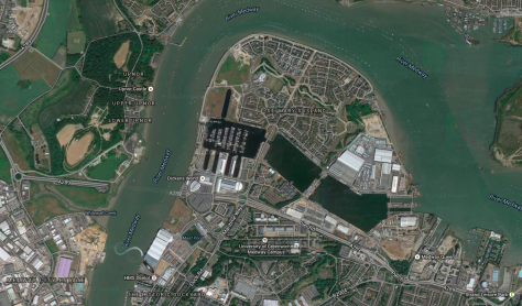
This is one of the first development shoots that I produced on the Thames Gateway and it is of a new development in Chatham called St Mary’s Island. I first became familiar with the development during my MA at UCA Rochester. The photography department was situated on the top floor of the building and had amazing views across the Medway Valley. Our MA room had no windows or natural lighting, so I would regularly have to go out to the corridor to soak up my much needed daylight, to stop the cabin fever of constant Photoshop retouching, and to enjoy my mug of noodles. I would stand staring out of the huge picture windows, a view that took in Rochester castle and Cathedral, the huge war memorial on the headland, and carried on across the historic dockyards over to the Isle of Grain. Stuck on the edge of the peninsular was St Mary’s Island, just past the dockyards and the hanger housing Dickens World.

 Aerial Photo of St Mary’s Island[/caption]
While I was struggling to find my muse, I became interested in an area on my own doorstep. One mile from the university sits the old Chatham maritime dockyard.
In the mid 1990’s, the Government announced an international competition to create a master plan for the regeneration of St. Mary’s Island, a part of the former dockyard. Of the master plans submitted, Countryside Properties’ was the most visionary and they were chosen by English Partnerships to undertake the 150-acre residential redevelopment of the island.
St. Mary’s Island is a 150-acre residential redevelopment by Countryside Maritime, a joint venture between SEEDA and Countryside Properties that forms part of the 350 acre Chatham Maritime regeneration project. The regeneration of the island was always going to be more than just a building project. It was going to be a grand scheme to create a new way of life for people who valued the simple things: tranquility, harmony and community.
St. Mary’s Island has the unique distinction of being Britain’s first and only strategically planned island community.
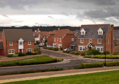
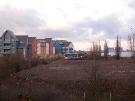
The architecture on the island changes according to phases of construction and were they are geographically situated on the island. The range from New England style wooden clad buildings to brick semi detached properties. I became interested in this architectural mix of styles and were they collided with one another creating juxtapositions of style.
Taken from my MA final Paper (2007)


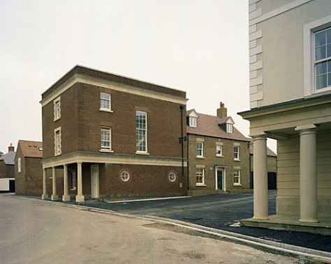
In reality the so called ‘Island Community’ is no different from the swathe of new housing developments up and down the country. It’s mixture of housing styles is a range of buildings in a series of faux fishing and scandinavean vernaculars. It’s the kind of development that takes it cues from HRH Prince Charles’ Poundbury development, kindly described by many as a bastardised view of history, the creation of a Thomas Hardy theme village, as depicted in Steffi Klenz’s 2005 work Non Such.


The same can be said about St Mary’s Island, it has all the realism and charm of the Next door Dickens World amusement. The developers have managed to sell the notion of a place that never existed on this site, a notion that many are happy to buy into, a safe mock existence to go with their Ikea interiors.


So if there is nothing remarkable about the buildings, why my passion for the location over such a long period of time? The answer to that is in the sites history and the legacy it leaves upon the landscape. The following is taken from Countryside Properties website.
The Beginning
The Romans found good use for the Island, even though it was little more than a marshy swamp criss-crossed by tidal channels. They constructed a road and established a ferry route from the Island to the Hoo Pensinsular. The ferry – incongruously named Prince’s Bridge on early maps – remained in constant use right up to the final years of the last century.
Dutch Invasion
The Island and St. Mary’s Creek (subsequently filled in to create the great Victorian basins we see today) – played an important part in the defence of England. Hurriedly, when an invading Dutch fleet was sighted in the summer of 1667, old ships were sunk across the creek and between St. Mary’s Island and the far bank of Upnor.
It was all to no avail, for the Dutch fleet sailed round the sunken vessels, smashed through a chain stretched from one side of the river to the other, and caused such destruction to the sheltering English fleet.
Convict Hulks
From the time of the Napoleonic wars to the end of the reign of Queen Victoria, the ox-bow reaches of the river off St. Mary’s Island were used to accommodate line upon line of hulked ships. These decommissioned naval vessels accommodated incarcerated hardened criminals and prisoners of war.
The Basins
At the height of Victorian England, thousands of convicts were used to dig out St. Mary’s Creek and construct, in its place, Basins One, Two and Three. The spoil was used to create St. Mary’s Island. Completed in the 1870s, the three Basins were used by Chatham Dockyard and warships of the Royal Navy for close on 100 years. It was closed in March 1984 by the Ministry of Defence with the loss of around 7,000 jobs and left a legacy of contamination that required extensive remediation before housebuilding could even start.
The Big Clean Up
The ground levels on St. Mary’s Island were originally made up from waste materials used at the brickworks and dockyard.
English Partnerships, who were initially responsible to the Secretary of State for the Environment, set about determining the nature and level of such wastes as an absolute priority. A detailed research plan to test the ground across the whole of the Island was therefore put into effect, extensively testing and retesting soil and water samples.
Once the testing process was completed, a programme of work was begun to bring the Island up to the most stringent levels recommended by government safety guidelines. A redundant pump house was excluded from the regeneration programme only to be demolished at a later date.
Over a three year period 1.2 million cubic metres of soil was taken away from the site and replaced. The extent of the clean-up operation and the attention to detail with which it was carried out can best be illustrated by the fact that for virtually three years, every four hours, twenty-four hours a day, a train left the site carrying away soil and unwanted deposits in covered containers.

Radiological testing was carried out by the Ministry of Defence and English Partnerships and checked annually by an independent assessor.
The history as portrayed by the developers is very limited, it’s largest period of use as a royal naval dock is dealt with in one paragraph and leaves you none the wiser to it’s real use. You then get to the almost throw away sentence about yearly radiation testing by the MOD. Is this standard for all ex MOD brownfield sites or something else? In reality the three big basins at St Mary’s were used for the refitting of Britain’s nuclear submarine fleet up until the dock closed in 1984, including refuelling of the submarines reactor core. Low-level radioactive waste was buried in the Dockyard near Gillingham Pier. Medium level radioactive waste (pumps etc.) was stored in the warehouse in the same location pending offsite disposal. The spent nuclear fuel was stored in the Core Pond, and placed directly in the nuclear flasks when Windscale (now Sellafield) had capacity to deal with it. It was possible to see Cherenkov’s Glow) in the Core Pond when spent fuel was stored. The blue glow is caused by negatively charged Beta particles travelling faster than the speed of light in water.

This interesting history has lead to a lot of discussion and ‘urban rumours’ on various local history forums, the following posts are taken from http://www.kenthistoryforum.co.uk/
• Bilgerat, Re: Radio-active waste Chatham Docks
when the navy had the yard, nuclear waste was stored in the old collier dock to the right of the south lock on the map. The river end of it had been bricked up and it was filled filled with water. I remember seeing the yellow radiation warning flags on poles all around the roof they built over it. The spent fuel from the submarine reactors was taken out in crash-proof flasks on special trains in the dead of night, with armed marine guards aboard. In the late 70’s a couple of local boys who lived up the road from me, i think their surname was Dallas, made the headlines in local papers when they scaled the wall and got into the nuclear waste storage facility.
• WildWeasel, Re: Radio-active waste Chatham Docks
So, the railway line from the dockyard runs in a cutting parallel to Rosebury Road / Richmond road.. It meets the main line just East of Gillingham station…Clearly visible on Google Maps…
I grew up in this area so we used to play on the line as kids…Big clue that it was used was the fact that the rails where always clean …IE No rust….
A mate of mine ( now sadly deceased ) Lived in Brooklyn Paddock next to the Bridge over the line at Burnt Oak Terrace …He took photo’s late one night of a train coming out of the Dockyard loaded with suspect containers…
He had a visit from MOD Police and was told to ” Be carefull “…………
We know Chatham was a base heavily involved with the re-fit of Nuclear Subs…So its obvious that there would have been a need to remove waste material from the spent reactors….Taking it out by train in the middle of the night would seem to be a sensible option…
MOD Banged to rights by this and other posts…
• Ben_10000, Re: Radio-active waste Chatham Docks
Very interesting topic, it seems that as kids we used to FISH within 50 meters of a Nuclear storage dump off of Gillingham pier. Well that was until one night when all the fish washed up dead, this would have been late 70’s… Many years later there were rumours of something to do with HMS Dreadnought coming up the river glowing; she never sailed under her own power again after her last visit to Chatham. But as this happened in the dark ages (pre google) little trace remains of articles about HMS Dreadnought, she had a mysterious machinary problem (possibly secondary coolant circuit) and as then laid up.
Its odd to think that we used to live so close to a Nuclear facility (I could see it from my bedroom) and that we fought to keep it too but it was jobs I guess, my father worked in the yard for many many years. I also remember that after the dockyard closed they left low and medium level waste behind.
Best access to the rail line for us kids used to be from the wooded area behind Hillyfields School where we used to muck about and fire pears at each other, happy days ☺ and as an adult I used to commute from a station that saw Atomic waste trains overnight but it never did us any harm now did it, ☺.
• ChrisExiledFromStrood, Re: Radio-active waste Chatham Docks
So to sum up the trains…
a. when the dockyard was operating, there were occasional workings of spent fuel from the subs travelling in the dead of night* with military escorts. Those wagons were much much bigger than the ones still used today for power station waste, with a sort of double bogie arrangement at each end. The escort staff rode in converted mainline coaches.
b. after it closed, there were the trains pictured earlier in the thread, carrying low-level waste for landfill. The sort that’s basically harmless after a few years in the ground.
*there was one incident where the train derailed in Gillingham sidings and was there for all to see the following morning in broad daylight, sometime around 1980. Not a serious derailment, probably just fell off a dodgy bit of old siding at low speed. Shame I didn’t have a camera then.

While there is no danger from the sites former use (that is known of) it is clear that this isn’t the kind of history the inhabitants would expect, and as well as the physical decontamination of the site, there is also a little historical decontamination to avoid any of the hysteria that surrounds anything related to nuclear energy. The low level waste is still stored in a walled off area owned by the MOD, away from the housing development. It was originally thought to have a half-life of 25-30 years (the time needed to decompose to a safer state), but this figure is now apparently far higher based on increased levels of various radioactive compounds.
Like the rest of the Thames Gateway region, the Medway towns have an incredible amount of psychogeographic potential based on their maritime history and recent redevelopment.
The following images are all early developments, taken on a borrowed Hasselblad H2D. I am not happy with them at this stage as they are to detached from the resonance of the location, and the digital format adds a sense of hypereality that I don’t want in the images as the site study progresses. The images are designed to ape the publicity material of the developers and slowly reveal elements of it’s unfinished state and industrial neighbours. I used a longer lens than my normal wide angle to create a visual compression within the plains of the image, as an attempt to document the claustrophobia of the over developed site.


